The Free Port of Trieste is a port in the Adriatic Sea in Trieste, Italy.

The Central Waterfront of Seattle, in the state of Washington, US, is the most urbanized portion of the Elliott Bay shore. It runs from the Pioneer Square shore roughly northwest past Downtown Seattle and Belltown, ending at the Broad Street site of the Olympic Sculpture Park.

Langelinie is a pier, promenade and park in central Copenhagen, Denmark, and home of The Little Mermaid statue. The area has for centuries been a popular destination for excursions and strolls in Copenhagen. Most cruise ships arriving in Copenhagen also berth at Langelinie Pier.

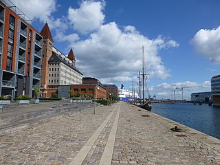
Holmen is a water-bound neighbourhood in Copenhagen, Denmark, occupying the former grounds of the Royal Naval Base and Dockyards. In spite of its name, deceptively in singular, Holmen is a congregation of small islands, forming a north-eastern extension of Christianshavn between Zealand and the northern tip of Amager.
The Port of Zhanjiang is a natural deepwater harbor in Southeast China. It was designed and reconstructed as China's first modern port, the project being commenced in 1956. After nearly 50 years of construction, the existing 39 wharves are able to handle the containers, general cargo and bulk cargo that arrives at the port. It also has facilities for dangerous goods, petroleum, chemicals, liquid chemicals, storage, packaging, commercial and transit passengers, ferries, freight forwarding, shipping agents, ship transport, bonded warehouses and exports. Since 2004, the port has become a land, sea and air transport hub.

Mersin Harbor is a seaport facility in Mersin, southern Turkey. As one of the largest harbors in the country, it is Turkey's main gateway to the Mediterranean Sea. It was constructed during the 1950s as a major government project.

111 Eighth Avenue is a full-block Art Deco multi-use building located between Eighth and Ninth Avenues, and 15th and 16th Streets in the Chelsea neighborhood of Manhattan, New York City.

Dahlerups Pakhus, originally known as Pakhus 1, is a former Warehouse situated on the west side of the Langelinie Pier, opposite the Middle Pier, in Copenhagen, Denmark. Designed by Vilhelm Dahlerup, from whom it now takes its name, it was built between 1892 and 1893.
Havnegade is a waterfront promenade in central Copenhagen, Denmark, which runs between Knippelsbro and the mouth of the Nyhavn canal. Most of the street is lined with buildings from the 1860s and 1870s that were constructed as part of the redevelopment of the Gammelholm navel dockyards. It is the only place along Copenhagen's main harbourfront where residential buildings of that age face the water, although older warehouses and other industrial buildings elsewhere have been converted into residential use. The Modernist Bank of Denmark building is located at the western end of the street.

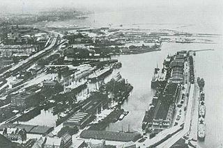
Amerika Plads is a public square and surrounding neighbourhood in the Østerbro district of Copenhagen, Denmark. It is the result of a redevelopment of an area in the southern part of the former Freeport of Copenhagen into a mixed-use neighbourhood which consists of dwellings, offices and retail establishments, combining converted historic buildings and modern architecture. The former Free Port Station building was put in storage during the redevelopment and is now located in the middle of the square where it serves as a café. The area is to the west bounded by Kalkbrænderihavnsgade, part of a major thoroughfare, and to the east by Dampfærgevej connected to Kalkbrænderihavnsgade in both ends and separating Amerika Plads from America Quay, the western quay of the Southern Free Port dock. The name of the area, like that of the quay, is a reference to the large passenger ships which used to transport Danish emigrants to New York City during the first half of the 20th century.
Toldbodgade is a street in central Copenhagen, Denmark. It extends north from Nyhavn at the Nyhavn Bridge, continuing Holberggade, passes Sankt Annæ Plads after just one block, and continues straight until it reaches West India Warehouse where it makes a sharp left turn which connects it to Amaliegade, its parallel street, at the rear of the Design Museum.

Nordre Toldbod is a waterfront area in Copenhagen, Denmark, located at the north end of Larsens Plads and just south of Kastellet. It takes its name after the custom house or toldbod which used to be located in the area. Most of the historic buildings in the area were torn down in 1973 when the site was redeveloped but its central waterfront space has remained intact and features a number of structures which bear testament to its former use. Among the modern buildings in the area are the headquarters of Mærsk and the Danish Energy Agency. The area is adjacent to Churchill and Langelinie Parks.

The Gustmeyer House is a historic property on Ved Stranden, opposite Christiansborg Palace on Slotsholmen, in central Copenhagen, Denmark. It was built in 1797 to a Neoclassical design by Johan Martin Quist. The Nobel Prize-winning physicist Niels Bohr was born in the building. McKinsey & Company is now based in the building.
Amerikakaj is a 700 metre long quay along the west side of the Søndre Frihavn dock in Copenhagen, Denmark. The name commemorates the transatlantic passenger ships of the Scandinavian America Line which used to berth along the quay during the first half of the 20th century. Today DFDS's ferries to Oslo berth at its north end.
Marmormolen is a wharf in the Søndre Frihavn area of Copenhagen, Denmark. Currently under redevelopment, a new office building for the United Nation's activities in Copenhagen is being built at its tip. The plans also include a highrise which will be connected to another highrise at the tip of Langelinie Pier across the entrance to the Søndre Frihavn dock by a pedestrian and cycling bridge 65 meters above the harbor.
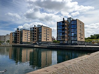
Århusgade is a street in the Østerbro district of Copenhagen, Denmark. It extends east from Østerbrogade and passes under the railway just before entering the southernmost part of Nordhavn which is known as the Århusgade neighbourhood after it. The street has many cafés and small shops. The street is named after the City of Aarhus, the second largest city in Denmark.

Slotsholmsgade is a street which runs along the rear side of Børsen on Slotsholmen in central Copenhagen, Denmark. Located next to the Danish parliament building Christiansborg, most of the buildings in the street house government offices. Several of them date from the 17th and 18th century and are listed.

The Five Sisters is a building and silo complex in Aarhus, Denmark which is an Industrial Heritage Site of Denmark. It is situated on the Mellemarmen pier on the industrial section of the Port of Aarhus in Aarhus city center. The silos represent the transition from manual to mechanized labor during the second wave of industrialization in the early 20th century and is symptomatic of the relationship between agriculture, industry and transport in the city. The Five Sisters were the first reinforced concrete structure to be erected in Aarhus and at the time it was the only building apart from the cathedral to rise above the city.