Related Research Articles

Belize is a country on the north-eastern coast of Central America. It is bordered by Mexico to the north, the Caribbean Sea to the east, and Guatemala to the west and south. It also shares a water boundary with Honduras to the southeast. It has an area of 22,970 square kilometres (8,867 sq mi) and a population of 441,471 (2022). Its mainland is about 290 km (180 mi) long and 110 km (68 mi) wide. It is the least populated and least densely populated country in Central America. Its population growth rate of 1.87% per year is the second-highest in the region and one of the highest in the Western Hemisphere. Its capital is Belmopan, and its largest city is the namesake city of Belize City. Belize is often thought of as a Caribbean country in Central America because it has a history similar to that of English-speaking Caribbean nations. Belize's institutions and official language reflect its history as a British colony.

Dangriga, formerly known as Stann Creek Town, is a town in southern Belize, located on the Caribbean coast at the mouth of the North Stann Creek River. It is the capital of Belize's Stann Creek District. Dangriga is served by the Dangriga Airport. Commonly known as the "culture capital of Belize" due to its influence on punta music and other forms of Garifuna culture, Dangriga is the largest settlement in southern Belize.

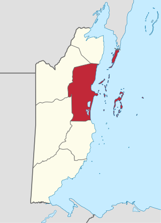
Stann Creek District is a district in the south east region of Belize. According to the 2010 census, the district had a population of 32,166 people. Its capital is the town of Dangriga, formerly known as "Stann Creek Town." Stann comes from "stanns," or safe havens used by colonialists coming from the "old world" to the "new world."

Toledo District is the southernmost and least populated district in Belize. Punta Gorda is the District capital. According to the Human Development Index (HDI), it is the second most developed region in the country. The district has a diverse topography which features rainforests, extensive cave networks, coastal lowland plains, and offshore cays. Toledo is home to a wide range of cultures such as Mopan, Kekchi Maya, Creole, Garifuna, East Indians, Mennonites, Mestizos, and descendants of US Confederate settlers.
Belize District is a district of the nation of Belize. Its capital is Belize City.

Orange Walk District is a district in the northwest of the nation of Belize, with its district capital in Orange Walk Town.
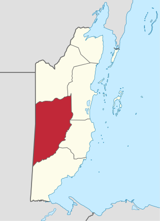
Cayo District is a district located in the west part of Belize. It is the most extensive, second-most populous and third-most densely populated of the six districts of Belize. The district's capital is the town of San Ignacio.

Belize is divided into six districts, those six are, from top to bottom, called Corozal, Orange Walk, Belize (District) Cayo, Stann Creek, and Toledo.

According to the 2010 census, the major languages spoken in Belize include English, Spanish and Kriol, all three spoken by more than 40% of the population. Mayan languages are also spoken in certain areas, as well as German.
Biscayne is a village in Belize District of the central-east coastal region of Belize. Though the area was originally inhabited by Mayans this village was established in the region of Belize that was first settled by Europeans. It is one of 192 municipalities administrated at the village level in the country for census taking purposes. The village had a population of 517 in 2010. This represents roughly 0.6% of the district's total population. This was a 33.90% increase from 386 people recorded in 2000. In terms of ethnicity, 85.5% were Creole, 6.8% Mestizo, 5.0% Mixed, 1.2% Garifuna, 0.8% East Indian, 0.2% African, 0.2% Caucasian, 0.2% Ketchi Maya and 0.2% others.
Lemonal is a village in the Belize District of the central-east coastal region of Belize. Though the area was originally inhabited by Mayans this village was established in the region of Belize that was first settled by Europeans. It is one of 192 municipalities administered at the village level in the country for census taking purposes. The village had a population of 169 in 2010. This represents roughly 0.2% of the district's total population. No census record was taken for the village in 2000.

Mahogany Heights is a village in the Belize District of the central-east coastal region of Belize. Though the area was originally inhabited by Mayans this village was established in the region of Belize that was first settled by Europeans. It is one of 192 municipalities administered at the village level in the country for census taking purposes. The village had several stores and a population of 1,063 in 2010. This represents roughly 1.2 % of the district's total population. No census record was taken for the village in 2000. Mahogany Heights was named for the Honduras Mahogany tree which was cut down as a chief export of Belize during the colonial period.
St. Ann's is a village in the Belize District of the central-east coastal region of Belize. Though the area was originally inhabited by Mayans this village was established in the region of Belize that was first settled by Europeans. It is one of 192 municipalities administrated at the village level in the country for census taking purposes. The village had a population of 97 in 2010. This represents roughly 0.1% of the district's total population. No census record was taken for the village in 2020.
Central Farm is a village in the Cayo District of central interior Belize. The village is in an agricultural region with the most frequent crops being citrus and banana. It is one of 192 municipalities administered at the village level in the country for census taking purposes. The village had a population of 205 in 2010. This represents roughly 0.3 % of the district's total population. This was a 3% increase from 199 people recorded in the 2000 census. The village of Central Farm hosts the "Taiwan Technical Mission in Beleize" which acts as a Taiwanese agricultural mission to support improved farming practices in Belize as part of Belize–Taiwan relations.
Duck Run III, alternatively known as Duck Run 3, is a village in the Cayo District of central interior Belize.The village is in an agricultural region where the most common crops are citrus and banana. It is one of 192 village level municipalities for census purposes. The village had a population of 400 in 2010. This represents roughly 0.6% of the district's total population. No census record was taken for the village in 2000. Duck Run III is one of three recognized municipalities with the name "Duck Run" south of Spanish Lookout having its own local government. The other two communities are Duck Run I and Duck Run II.
Los Tambos is a village in the Cayo District of central interior Belize. The village is in an agricultural region with the most frequent crops being citrus and banana. It is one of 192 municipalities administrated at the village level in the country for census taking purposes. The village had a population of 358 in 2010. This represents roughly 0.5 % of the district's total population. This was a 108.1% increase from 172 people recorded in the 2000 census.
Paslow Falls/Plant is a census designated village on the Mopan River in the Cayo District of central interior Belize. In reality this village includes properties on Paslow Falls Road and around the Water Treatment Plant serving the greater Bullet Tree Falls community which this area lies on the northwest corner of. The village is in an agricultural region with the most frequent crops being citrus and banana. It is one of 192 municipalities administrated at the village level in the country for census taking purposes. The village had a population of 194 in 2010. This represents roughly 0.3 % of the district's total population. No census record was taken for the village in 2000.
Santa Marta is a village in the Cayo District of central interior Belize. The village is in an agricultural region with the most frequent crops being citrus and banana. It is one of 192 municipalities administrated at the village level in the country for census taking purposes. The village had a population of 1,136 in 2010. This represents roughly 1.7 % of the district's total population. This was a 60% increase from 711 people recorded in the 2000 census.
Santa Rosa is a village in the Cayo District of central interior Belize. The village is in an agricultural region with the most frequent crops being citrus and banana. It is one of 192 municipalities administered at the village level in the country for census taking purposes. The village had a population of 64 in 2010. This represents roughly 0.1 % of the district's total population. This was a 38.5% decrease from 104 people recorded in the 2000 census.
References
| | This article about the geography of Belize is a stub. You can help Wikipedia by expanding it. |