
In aviation, instrument flight rules (IFR) is one of two sets of regulations governing all aspects of civil aviation aircraft operations; the other is visual flight rules (VFR).
In aviation, visual flight rules (VFR) are a set of regulations under which a pilot operates an aircraft in weather conditions generally clear enough to allow the pilot to see where the aircraft is going. Specifically, the weather must be better than basic VFR weather minima, i.e., in visual meteorological conditions (VMC), as specified in the rules of the relevant aviation authority. The pilot must be able to operate the aircraft with visual reference to the ground, and by visually avoiding obstructions and other aircraft.
The Federal Aviation Regulations (FARs) are rules prescribed by the Federal Aviation Administration (FAA) governing all aviation activities in the United States. The FARs comprise Title 14 of the Code of Federal Regulations. A wide variety of activities are regulated, such as aircraft design and maintenance, typical airline flights, pilot training activities, hot-air ballooning, lighter-than-air aircraft, human-made structure heights, obstruction lighting and marking, model rocket launches, commercial space operations, model aircraft operations, unmanned aircraft systems (UAS) and kite flying. The rules are designed to promote safe aviation, protecting pilots, flight attendants, passengers and the general public from unnecessary risk.
Airspace is the portion of the atmosphere controlled by a country above its territory, including its territorial waters or, more generally, any specific three-dimensional portion of the atmosphere. It is not the same as outer space which is the expanse or space outside the Earth and aerospace which is the general term for Earth's atmosphere and the outer space within the planet's vicinity.

In the United States, airways or air routes are defined by the Federal Aviation Administration (FAA) in two ways:
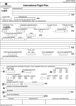
Flight plans are documents filed by a pilot or flight dispatcher with the local Air Navigation Service Provider prior to departure which indicate the plane's planned route or flight path. Flight plan format is specified in ICAO Doc 4444. They generally include basic information such as departure and arrival points, estimated time en route, alternate airports in case of bad weather, type of flight, the pilot's information, number of people on board, and information about the aircraft itself. In most countries, flight plans are required for flights under IFR, but may be optional for flying VFR unless crossing international borders. Flight plans are highly recommended, especially when flying over inhospitable areas such as water, as they provide a way of alerting rescuers if the flight is overdue. In the United States and Canada, when an aircraft is crossing the Air Defense Identification Zone (ADIZ), either an IFR or a special type of VFR flight plan called a DVFR flight plan must be filed. For IFR flights, flight plans are used by air traffic control to initiate tracking and routing services. For VFR flights, their only purpose is to provide needed information should search and rescue operations be required, or for use by air traffic control when flying in a "Special Flight Rules Area."
The world's navigable airspace is divided into three-dimensional segments, each of which is assigned to a specific class. Most nations adhere to the classification specified by the International Civil Aviation Organization (ICAO) and described below, though they might use only some of the classes defined below, and significantly alter the exact rules and requirements. Similarly, individual nations may also designate special use airspace (SUA) with further rules for reasons of national security or safety.

Pilot certification in the United States is typically required for an individual to act as a pilot-in-command of an aircraft. It is regulated by the Federal Aviation Administration (FAA), a branch of the U.S. Department of Transportation (USDOT). A pilot may be certified under 14 Code of Federal Regulations (CFR) Part 61 or 14 CFR Part 141. Pilots may also be certified under 14 CFR Part 107 for commercial drone operations.

Trans World Airlines (TWA) Flight 553 was a McDonnell Douglas DC-9-15 jet airliner, registration N1063T, operated by Trans World Airlines on March 9, 1967 between Pittsburgh, Pennsylvania and Dayton, Ohio. While descending toward Dayton about 29 miles from the airport, the flight collided in midair with a Beechcraft Baron, a small, general-aviation airplane, near Urbana, Ohio. All 25 aboard the DC-9 and the sole occupant of the Beechcraft were killed.
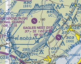
Restricted airspace is an area of airspace typically used by the military in which the local controlling authorities have determined that air traffic must be restricted or prohibited for safety or security concerns. It is one of many types of special use airspace designations and is depicted on aeronautical charts with the letter "R" followed by a serial number.

Ultralight aircraft exist outside of the United States. In most countries, ultralights are a class of aircraft. A completely different legal concept is valid within the USA. The FAA makes explicitly clear that ultralight vehicles are not aircraft, are not regulated as aircraft, and are exempt from aircraft rules. Instead, they are treated as powersport items and have to follow their own ruleset, FAR-103, which is the most compact aviation regulation in existence. It can be printed on the front- and backside of a single piece of paper.

Allegheny Airlines Flight 853 was a regularly scheduled Allegheny Airlines flight from Boston, Massachusetts, to St. Louis, Missouri, with stops in Baltimore, Maryland, Cincinnati, Ohio, and Indianapolis, Indiana. On September 9, 1969, the aircraft serving the flight, a McDonnell Douglas DC-9, collided in mid-air with a Piper PA-28 light aircraft near Fairland, Indiana. The DC-9 was carrying 78 passengers and 4 crew members, and the Piper was leased to a student pilot on a solo cross-country flight. All 83 occupants of both aircraft were killed in the accident and both aircraft were destroyed.
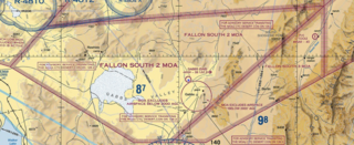
A military operations area (MOA) is an airspace established outside Class A airspace to separate or segregate certain nonhazardous military activities from IFR Traffic and to identify for VFR traffic where these activities are conducted. Similar structures exist under international flight standards. These are designed for routine training or testing maneuvers. Areas near actual combat or other military emergencies are generally designated as restricted airspace. See Temporary Flight Restriction (TFR).

Special use airspace (SUA) is a type of special airspaces in the United States designated for operations of a nature such that limitations may be imposed on aircraft not participating in those operations. Often these operations are of a military nature. The designation of SUAs identifies for other users the areas where such activity occurs, provides for segregation of that activity from other users, and allows charting to keep airspace users informed of potential hazards.

A transponder is an electronic device that produces a response when it receives a radio-frequency interrogation. Aircraft have transponders to assist in identifying them on air traffic control radar. Collision avoidance systems have been developed to use transponder transmissions as a means of detecting aircraft at risk of colliding with each other.

The United States airspace system's classification scheme is intended to maximize pilot flexibility within acceptable levels of risk appropriate to the type of operation and traffic density within that class of airspace – in particular to provide separation and active control in areas of dense or high-speed flight operations.
In the United States, skydiving is a self-regulated sport, which means skydivers, in the US, voluntarily follow a set of basic safety requirements established by the U.S. Parachute Association. Federal requirements can be found in the Federal Aviation Regulations. Most of the regulations concern the aircraft, pilot and rules of flight. However, 14 CFR Part 105, "Parachute Operations" regulates when and where jumps may be made and designates the requirements for parachute equipment and packing. For example, 14 CFR Part 105 requires the person packing either the main chute or the reserve parachute to be a certificated rigger, which means he or she has taken an FAA-approved training course and has passed rigorous FAA testing.
In United States aviation, a special flight rules area (SFRA) is a region in which the normal regulations of flight do not apply in whole or in part, especially regulations concerning airspace classification, altitude, course, and speed restrictions, and the like.
This is a glossary of acronyms, initialisms and terms used for gliding and soaring. This is a specialized subset of broader aviation, aerospace, and aeronautical terminology. Additional definitions can be found in the FAA Glider Flying Handbook.

Ozark Air Lines Flight 965 was a scheduled commercial flight from Chicago, Illinois, to Lambert Field in St. Louis, Missouri, with a scheduled intermediate stopover at Greater Peoria Regional Airport in Peoria, Illinois. On March 27, 1968, the Douglas DC-9-15 jetliner operating the flight, carrying 44 passengers and five crew, collided in mid-air with a single-engined Cessna 150F while both aircraft were on approach to the same runway at Lambert Field. The DC-9 landed safely with no injuries to any of its 49 occupants, while both pilots in the two-person Cessna died in the collision and subsequent ground impact.
The Department of Defense publication AP-1/B lists all military training routes in North America. Military training routes are depicted on FAA VFR sectional aeronautical charts as narrow gray lines with IR or VR designator prefixes.