Related Research Articles

Sullivan County is a county in the Commonwealth of Pennsylvania. As of the 2020 census, the population was 5,840, making it the second-least populous county in Pennsylvania. Its county seat is Laporte. The county was created on March 15, 1847, from part of Lycoming County and named for Major General John Sullivan. The county is part of the Northeast Pennsylvania region of the state.

Lycoming County is a county in the Commonwealth of Pennsylvania. As of the 2020 census, the population was 114,188. Its county seat is Williamsport. The county is part of the North-Central Pennsylvania region of the state.

Montgomery is a borough in Lycoming County, Pennsylvania, United States. The population was 1,570 at the 2020 census. It is part of the Williamsport, Pennsylvania Metropolitan Statistical Area.

Montoursville is a borough in Lycoming County, Pennsylvania. The 2020 census reported its population as 4,745. It forms part of the Williamsport, Pennsylvania Metropolitan Statistical Area. The Williamsport Regional Airport is in Montoursville.

Plunketts Creek Township is a township in Lycoming County, Pennsylvania, United States. It includes the villages of Barbours and Proctor. The population was 595 at the 2020 census, down from 684 at the 2010 census. It is part of the Williamsport Metropolitan Statistical Area.

William Penn State Forest is a Pennsylvania State Forest in Pennsylvania Bureau of Forestry District #17. The main offices are located in Elverson in Chester County, Pennsylvania in the United States.

Loyalsock Creek is a 64-mile-long (103 km) tributary of the West Branch Susquehanna River located chiefly in Sullivan and Lycoming counties in Pennsylvania in the United States. As the crow flies, Lycoming County is about 130 miles (209 km) northwest of Philadelphia and 165 miles (266 km) east-northeast of Pittsburgh.

White Deer Hole Creek is a 20.5-mile (33.0 km) tributary of the West Branch Susquehanna River in Clinton, Lycoming and Union counties in the U.S. state of Pennsylvania. A part of the Chesapeake Bay drainage basin, the White Deer Hole Creek watershed drains parts of ten townships. The creek flows east in a valley of the Ridge-and-valley Appalachians, through sandstone, limestone, and shale from the Ordovician, Silurian, and Devonian periods.

Little Loyalsock Creek is the major tributary of Loyalsock Creek in Lycoming and Sullivan counties, Pennsylvania, United States. The creek is 19.3 miles (31.1 km) long. Via Loyalsock Creek and the West Branch Susquehanna River, it is part of the Susquehanna River drainage basin, and waters from it flow ultimately into the Chesapeake Bay.
Conewago Creek is a 23.0-mile-long (37.0 km) tributary of the Susquehanna River in Lebanon, Dauphin, and Lancaster counties in Pennsylvania in the United States. The source is at an elevation of 1,100 feet (340 m) at Mount Gretna Heights in Lebanon County. The mouth is the confluence with the Susquehanna River at an elevation of 261 feet (80 m) at the border of Dauphin and Lancaster counties, just south of Three Mile Island in the river and just north of the unincorporated village of Falmouth in Conoy Township, Lancaster County.

Conewago Creek is an 80.2-mile-long (129.1 km) tributary of the Susquehanna River in Adams and York counties in Pennsylvania in the United States, with its watershed also draining a small portion of Carroll County, Maryland. The source is at an elevation of 1,440 feet (440 m), east of Caledonia State Park, in Franklin Township in Adams County. The mouth is the confluence with the Susquehanna River at York Haven in York County at an elevation of 259 feet (79 m).
Fishing Creek is an 11.5-mile-long (18.5 km) tributary of the Susquehanna River in Dauphin County, Pennsylvania, in the United States.

Plunketts Creek is an approximately 6.2-mile-long (10 km) tributary of Loyalsock Creek in Lycoming and Sullivan counties in the U.S. state of Pennsylvania. Two unincorporated villages and a hamlet are on the creek, and its watershed drains 23.6 square miles (61 km2) in parts of five townships. The creek is a part of the Chesapeake Bay drainage basin via Loyalsock Creek and the West Branch Susquehanna and Susquehanna Rivers.
Bear Creek is a 6.2-mile-long (10.0 km) tributary of Loyalsock Creek in Lycoming County, Pennsylvania, in the United States.

Pleasant Stream is a 13.1-mile-long (21.1 km) tributary of Lycoming Creek in Lycoming and Sullivan counties, Pennsylvania, in the United States.
The Sonestown Covered Bridge is a covered bridge over Muncy Creek in Davidson Township, Sullivan County, Pennsylvania built around 1850. It is 110 ft (34 m) long and was placed on the National Register of Historic Places (NRHP) in 1980. It is named for the nearby unincorporated village of Sonestown in Davidson Township, and is also known as the Davidson Covered Bridge. It was built to provide access to a grist mill which operated until the early 20th century.

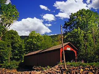
The Forksville Covered Bridge is a Burr arch truss covered bridge over Loyalsock Creek in the borough of Forksville, Sullivan County, in the U.S. state of Pennsylvania. It was built in 1850 and is 152 feet 11 inches (46.61 m) in length. The bridge was placed on the National Register of Historic Places in 1980. The Forksville bridge is named for the borough it is in, which in turn is named for its location at the confluence or "forks" of the Little Loyalsock and Loyalsock Creeks.
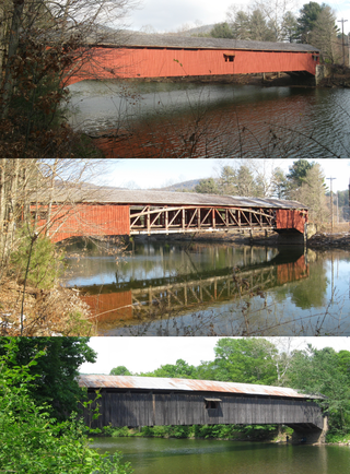
The Hillsgrove Covered Bridge is a Burr arch truss covered bridge over Loyalsock Creek in Hillsgrove Township, Sullivan County, in the U.S. state of Pennsylvania. It was built c. 1850 and is 186 feet (56.7 m) long. In 1973, it became the first covered bridge in the county to be placed on the National Register of Historic Places (NRHP). The bridge is named for the township and nearby unincorporated village of Hillsgrove, and is also known as Rinkers Covered Bridge for an adjoining farm.
References
- Pennsylvania Department of Transportation, Bureau of Planning and Research, Geographic Information Division. "2007 General Highway Map Lycoming County Pennsylvania" (PDF). Retrieved 2007-10-01.
{{cite news}}: CS1 maint: multiple names: authors list (link)[ permanent dead link ] - Pennsylvania Department of Transportation, Bureau of Planning and Research, Geographic Information Division. "2007 General Highway Map Sullivan County Pennsylvania" (PDF). Archived from the original (PDF) on 2014-06-02. Retrieved 2007-10-01.
{{cite news}}: CS1 maint: multiple names: authors list (link)
41°14′02″N76°56′26″W / 41.233897°N 76.940426°W
| | This Lycoming County, Pennsylvania state location article is a stub. You can help Wikipedia by expanding it. |
| | This Sullivan County, Pennsylvania state location article is a stub. You can help Wikipedia by expanding it. |