
Swansea is a coastal city and the second-largest city of Wales. It forms a principal area, officially known as the City and County of Swansea.

Dyfed is a preserved county in southwestern Wales. It is a mostly rural area with a coastline on the Irish Sea and the Bristol Channel.
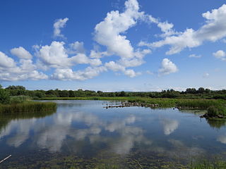
WWT Llanelli Wetland Centre at Llanelli, Carmarthenshire, Wales is one of ten wetland nature reserves in the UK managed by the Wildfowl and Wetlands Trust, a nature conservation charity. The visitor centre has accessible toilets, a coffee shop and retail area. During school holidays, there are nature-based activities and events.

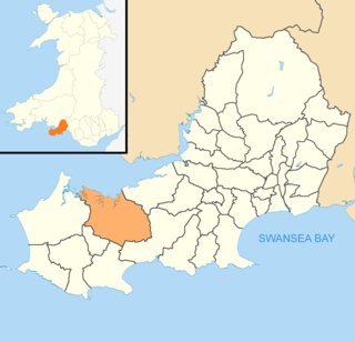
Carmarthenshire is a county in the south-west of Wales. The three largest towns are Llanelli, Carmarthen and Ammanford. Carmarthen is the county town and administrative centre. The county is known as the "Garden of Wales" and is also home to the National Botanic Garden of Wales.

The Bristol Channel is a major inlet in the island of Great Britain, separating South Wales and South West England. It extends from the smaller Severn Estuary of the River Severn to the North Atlantic Ocean. It takes its name from the English city and port of Bristol

Llanelli is a market town and community in Carmarthenshire and the preserved county of Dyfed, Wales. It is located on the Loughor estuary and is the largest town in the county of Carmarthenshire. The town is 11 miles (18 km) north-west of Swansea and 12 miles (19 km) south-east of Carmarthen. The town had a population of 25,168 in 2011, estimated in 2019 at 26,225. The local authority was Llanelli Borough Council when the county of Dyfed existed, but it has been under Carmarthenshire County Council since 1996.

Burry Port is a port town and community in Carmarthenshire, Wales, on the Loughor estuary, to the west of Llanelli and south-east of Kidwelly. Its population was recorded at 5,680 in the 2001 census and 6,156 in the 2011 census, and estimated at 5,998 in 2019. The town has a harbour. It is also where Amelia Earhart landed as the first woman to fly across the Atlantic Ocean. Nearby are the Pembrey Burrows sand dune and wetland system, forming a country park, and the Cefn Sidan sands. Its musical heritage includes Burry Port Opera, Male Choir and Burry Port Town Band.

Carmarthen Bay is an inlet of the South Wales coast, including notable beaches such as Pendine Sands and Cefn Sidan sands. Carmarthen Bay is partially within the Pembrokeshire Coast National Park. The Joint Nature Conservation Committee list Carmarthen Bay and Estuaries as a Special Area of Conservation.

Bridgend County Borough is a county borough in the south-east of Wales. The county borough has a total population of 139,200 people, and contains the town of Bridgend, after which it is named. Its members of the Senedd are Sarah Murphy MS, representing the Bridgend Constituency, and Huw Irranca-Davies MS representing the Ogmore Constituency, and its members of the UK parliament are Jamie Wallis and Chris Elmore.
Pembrey Burrows stretch from Burry Port's harbour area – a former coal port, now a marina – to Pembrey Country Park, a leisure and nature complex that is one of West Wales's leading visitor attraction.

Cefn Sidan, translated from Welsh, means "silky ridge". This long sandy beach and its dunes form the outer edge of the Pembrey Burrows between Burry Port and Kidwelly, facing southwestwards over Carmarthen Bay in South Wales. Cefn Sidan beach is backed by dunes, salt marshes, Pembrey Forest and the Pembrey Country Park.

The River Loughor is a river in Wales which marks the border between Carmarthenshire and Swansea. The river is sourced from an underground lake at the Black Mountain emerging at the surface from Llygad Llwchwr which translates from the Welsh as "eye of the Loughor". It flows past Ammanford and Hendy in Carmarthenshire and Pontarddulais in Swansea. The river divides Carmarthenshire from Swansea for much of its course and it separates Hendy from Pontarddulais at the point where the river becomes tidal. The Loughor meets the sea at its estuary near the town of Loughor where it separates the south coast of Carmarthenshire from the north coast of the Gower Peninsula. Among its tributaries is the River Amman, which joins the Loughor near Pantyffynnon. The area of the catchment is some 262 square kilometres (101 sq mi).
Llanrhidian Lower is a community in the Gower peninsula forming the west of Swansea, south Wales. The community has its own elected community council. The population was 512 as of the 2011 UK census.
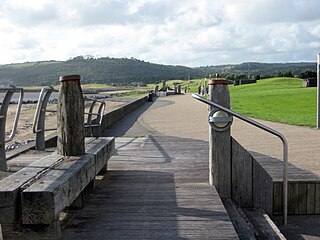
The Millennium Coastal Path is a 13 miles (21 km) pedestrian walkway and cycleway along the south coast of Carmarthenshire, providing a link between Llanelli and Pembrey Country Park. The cycleway forms a section of both the Celtic Trail cycle route and the National Cycle Network NCN 4.

Machynys, or Machynys Peninsula is a coastal area just to the south of Llanelli in Carmarthenshire, Wales. In the nineteenth century an industrial community lived here working at the brickworks and tinplate works that occupied the site. When the industrial activity ceased in the mid-twentieth century, the buildings were demolished and the site lay derelict. It has now been redeveloped as a golf course as part of the Llanelli Waterside regeneration plan.

Newport Wetlands is a wildlife reserve covering parts of Uskmouth, Nash and Goldcliff, in the south-east of the city of Newport, South Wales.

The Wales Coast Path is a designated long-distance trail which follows, or runs close to, the coastline of Wales.

