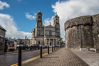
Athlone is a town on the border of County Roscommon and County Westmeath, Ireland. It is located on the River Shannon near the southern shore of Lough Ree. It is the second most populous town in the Midlands Region with a population of 22,869 in the 2022 census.

County Longford is a county in Ireland. It is in the province of Leinster. It is named after the town of Longford. Longford County Council is the local authority for the county. The population of the county was 46,634 at the 2022 census. The county is based on the historic Gaelic territory of Annaly (Anghaile), formerly known as Teffia (Teathbha).
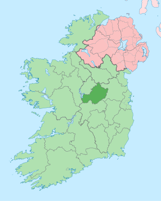
County Westmeath is a county in Ireland. It is in the province of Leinster and is part of the Eastern and Midland Region. It formed part of the historic Kingdom of Meath, which was named Mide because the kingdom was located in the geographical centre of Ireland. Westmeath County Council is the administrative body for the county, and the county town is Mullingar. At the 2022 census, the population of the county was 95,840.

Mullingar is the county town of County Westmeath in Ireland. It is the third most populous town in the Midland Region, with a population of 22,667 in the 2022 census.

Moate is a town in County Westmeath, Ireland. As of the 2022 census, it had a population of 3,013.

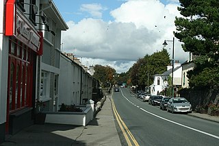
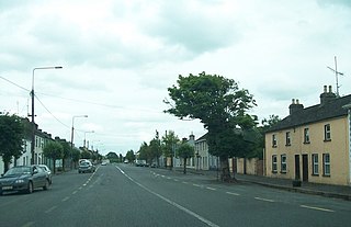
Kinnegad is a town in County Westmeath, Ireland. It is on the border with County Meath, near the junction of the M6 and the M4 motorways - two of Ireland's main east–west roads. It is roughly 60 km from the capital, Dublin.

Lough Ree, translated to English as King's Lake or King Lake, is a lake in the midlands of Ireland, the second of the three major lakes on the River Shannon. Lough Ree is the second largest lake on the Shannon after Lough Derg. The other two major lakes are Lough Allen to the north, and Lough Derg to the south. There are also several minor lakes along the length of the river. The lake serves as a border between the counties of Longford and Westmeath on the eastern side and County Roscommon in the province of Connacht on the western side. The lake is popular for fishing and boating. The lake supports a small commercial eel fishery and is locally famous for its eels on wheels truck. The town of Athlone is situated at the southern end of the lake, and has a harbour for boats going out on the lake. The small town of Lanesboro is at the northern end of the lake.

Shannonbridge is a village located on the River Shannon, at the junction of the R444 and R357 regional roads in County Offaly, Ireland. It lies within the townland of Raghra, at the borders of counties Offaly, Galway and Roscommon, with the majority of the population living east of the bridge in County Offaly. As of the 2016 census, the village had a population of 175. There are two housing estates within the village. Its location along Ireland's largest river and its proximity to Clonmacnoise have contributed to tourism being a key contributor to the local economy. The village is flanked by a Special Area of Conservation – the Shannon Callows. The physical environment consists of the River Shannon, callows, boglands and the Esker Riada. The village has one of the oldest bridges still in use over the River Shannon, completed in 1757.
Glassan or Glasson, also the Village of the Roses, is a small village in rural County Westmeath, Ireland. It is 10 km (6.2 mi) north of Athlone, on the N55 national secondary road, not far from the shores of Lough Ree.
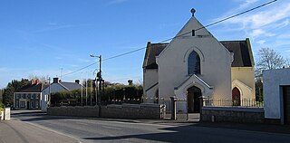
Raharney is a village in east County Westmeath, Ireland. It had a population of 221 according to the 2016 census.

Finnea is a small village in County Westmeath on the border with County Cavan. It straddles the R394 road, in the northern portion of Ireland.
Clonmellon is a small village officially in County Westmeath although on the border with County Meath, Ireland. It is situated on the N52 road between Kells in County Meath and Delvin in County Westmeath.
Milltownpass is a village in County Westmeath, Ireland. It is in the south of the county, 10 km south-east of Mullingar. The village is on the R446 regional road ; the old route was replaced by a dual-carriageway from Kinnegad to Tyrrellspass in 2006, bypassing the village. Milltownpass is the second largest village in the parish of Rochfortbridge. It was one of the first villages in Ireland to have its own electricity supply: a mill on the Milltown River providing power to the village long before rural electrification.

The River Inny is a river within the Shannon River Basin in Ireland. It is 88.5 kilometres (55.0 mi) in length, and has a number of lakes along its course.

Corkaree is a barony in north County Westmeath, Ireland. It was formed by 1672. It is bordered by three other baronies: Fore, Moyashel and Magheradernon and Moygoish.

Moygoish is a barony in north County Westmeath, in Ireland, formed by 1672. It is bordered by County Longford to the west and four other Westmeath baronies: Corkaree, Fore, Moyashel and Magheradernon and Rathconrath to the south–west.

Moyashel and Magheradernon is a barony in the centre of County Westmeath, in Ireland, formed by 1672. It is bordered by eight other baronies: Corkaree and Fore, Delvin and Farbill, Fartullagh and Moycashel and Rathconrath and Moygoish.
Brawny is a barony in south–west County Westmeath, Ireland. It was formed by 1672. It is bordered by County Roscommon to the west. It also borders two other Westmeath baronies: Kilkenny West and Clonlonan. The largest centre of population in the barony is the town of Athlone.

Clonlonan is a barony in south–west County Westmeath, Ireland. It was formed by 1672. It is bordered by County Offaly to the south and a small part of County Roscommon at Long Island on the River Shannon to the west. It also borders four other Westmeath baronies: Kilkenny West and Rathconrath, Moycashel and Brawny. The largest centre of population in the barony is the town of Moate.
