
Westchester County is a county located in the southeastern portion of the U.S. state of New York, bordering the Long Island Sound to its east and the Hudson River on its west. The county is the seventh most populous county in the State of New York and the most populous north of New York City. According to the 2020 United States Census, the county had a population of 1,004,456, its highest decennial count ever and an increase of 55,344 (5.8%) from the 949,113 counted in 2010. Westchester covers an area of 450 square miles (1,200 km2), consisting of six cities, 19 towns, and 23 villages. Established in 1683, Westchester was named after the city of Chester, England. The county seat is the city of White Plains, while the most populous municipality in the county is the city of Yonkers, with 211,569 residents per the 2020 census. The county is part of the Hudson Valley region of the state.

Putnam County is a county in the U.S. state of New York. As of the 2020 census, the population was 97,668. The county seat is Carmel, within one of the county's six towns. The county is part of the Hudson Valley region of the state.

Briarcliff Manor is a suburban village in Westchester County, New York, 30 miles (50 km) north of New York City. It is on 5.9 square miles (15 km2) of land on the east bank of the Hudson River, geographically shared by the towns of Mount Pleasant and Ossining. Briarcliff Manor includes the communities of Scarborough and Chilmark, and is served by the Scarborough station of the Metro-North Railroad's Hudson Line. A section of the village, including buildings and homes covering 376 acres (152 ha), is part of the Scarborough Historic District and was listed on the National Register of Historic Places in 1984. The village motto is "A village between two rivers", reflecting Briarcliff Manor's location between the Hudson and Pocantico Rivers. Although the Pocantico is the primary boundary between Mount Pleasant and Ossining, since its incorporation the village has spread into Mount Pleasant.

Elmsford is a village in Westchester County, New York, United States. It is part of the New York metropolitan area. Roughly one square mile, the village is fully contained within the borders of the town of Greenburgh. As of the 2010 census, the population of Elmsford was 4,664.

Yorktown is a town on the northern border of Westchester County, New York, United States. A suburb of the New York City metropolitan area, it is approximately 38 miles (61 km) north of midtown Manhattan. The population was 36,569 at the 2020 U.S. Census.
Yorktown Heights is a census-designated place (CDP) in the town of Yorktown in Westchester County, New York, United States. The population was 1,781 at the 2010 census.
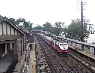
Philipse Manor station is a commuter rail stop on the Metro-North Railroad's Hudson Line, located in the Philipse Manor area of Sleepy Hollow, New York, United States.

Millwood is a hamlet and census-designated place located in the town of New Castle, New York, United States in Westchester County. It was originally settled as Sarlesville. The area now known as Millwood appears on 19th century maps as Merritt's Corners and Rockdale Mills. As of the 2000 census, the community had a population of 1,210.
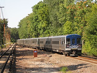
The Harlem Line is an 82-mile (132 km) commuter rail line owned and operated by the Metro-North Railroad in the U.S. state of New York. It runs north from New York City to Wassaic, in eastern Dutchess County. The lower 53 miles (85 km) from Grand Central Terminal to Southeast, in Putnam County, is electrified with a third rail and has at least two tracks. The section north of Southeast is a non-electrified single-track line served by diesel locomotives. Before the renaming of the line in 1983, it eventually became the Harlem Division of the New York Central Railroad. The diesel trains usually run as a shuttle on the northern end of the line, except for rush-hour express trains in the peak direction.
The New York and Putnam Railroad, nicknamed the Old Put, was a railroad line that operated between the Bronx and Brewster in New York State. It was in close proximity to the Hudson River Railroad and New York and Harlem Railroad. All three came under ownership of the New York Central system in 1894. The railroad was abandoned starting in 1958, and most of the former roadbed has been converted to rail trail use.

Getty Square is the name for downtown Yonkers, New York, centered on the public square. Getty Square is the civic center, central business district, and transit hub of the City of Yonkers. A dense and growing residential area, it is located in southern Westchester County, New York. The square is named after prominent 19th-century merchant Robert Getty.

Croton Falls station is a commuter rail stop on the Metro-North Railroad's Harlem Line, located in North Salem, New York.

New York State Route 120 (NY 120) is a state highway in southern Westchester County, New York, in the United States. It begins in the city of Rye at an intersection with U.S. Route 1 (US 1) and runs for about 18 miles (29 km) north to the hamlet of Millwood, where it ends at a junction with NY 100. The route intersects with Interstate 684 (I-684) and the Saw Mill River Parkway, and serves the Westchester County Airport in North Castle. Portions of the route have been signed ceremonially in remembrance of American serviceman killed in the 2000s and 2010s during the wars in Iraq and Afghanistan.

New Rochelle station is a Metro-North Railroad and Amtrak train station located in New Rochelle, New York. The station serves Metro-North's New Haven Line and Amtrak's Northeast Regional; Bee-Line Bus System buses serve a bus stop just outside the station. As of August 2006, weekday commuter ridership was 4,020, and there are 1,381 parking spots. It is the busiest New Haven Line station in Westchester County.

The North County Trailway is a 22.1-mile (35.6 km) long paved rail trail stretching from Eastview to Baldwin Place in Westchester County, New York. It is also part of the statewide Empire State Trail.

The South County Trailway is a 14.1-mile (22.7 km) long rail trail stretching from the Putnam Trail in Van Cortlandt Park in the Bronx to the North County Trailway in East View, New York. Westchester County Parks constructed the trailway in segments beginning in 1990 and completed it on October 31, 2017.
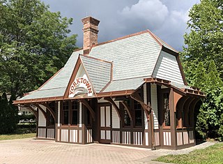
Yorktown Heights station is a former railroad station on the Putnam Line in Yorktown Heights, New York, United States. It is a wooden building located on Commerce Street at the intersection of Underhill Avenue in Railroad Park.
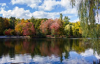
Woodlands Lake is a reservoir in Greenburgh, New York. It is an impoundment of the Saw Mill River. It is located in VE Macy Park.

The Briarcliff Manor Public Library is the public library serving the village of Briarcliff Manor, New York, and is located on the edge of the Walter W. Law Memorial Park. The library is a founding member of the Westchester Library System. It is staffed by a director and eleven employees, including reference and youth librarians, and is governed by a ten-member board, with a liaison to the village board of trustees. The library offers computer classes, book discussion groups, young adult programs, a children's room and a local history collection. The library building also houses the Briarcliff Manor-Scarborough Historical Society, the Briarcliff Manor Recreation Department, and the William J. Vescio Community Center.

Ithaca Bus Station, also referred to as Ithaca Bus Terminal, is an intercity bus station in Ithaca, the county seat and only city in Tompkins County, New York. The Prairie-style building, located west of North Fulton Street between West Seneca Street and West State Street, was designed by architect Frank J. Nies in 1912 as a train station of the Delaware, Lackawanna and Western Railroad. DL&W ceased passenger operations in 1942, and Greyhound Bus Lines acquired the station in 1967. The station building accommodates waiting area with seats, ticketing and package express office, and restrooms.
The station closed in October, 2018 due to construction, retirement of the station operators, and changing infrastructure in the area. Buses are now boarding downtown for the time being until long-term plans are made. The City of Ithaca designated the station as a local landmark in January, 2019.


