
Jackson Bay / Okahu is a gently curving bay 24 kilometres wide, located on the West Coast of New Zealand's South Island. It faces the Tasman Sea to the north, and is backed by the Southern Alps. The westernmost point of the bay is marked by the headland of Jackson Head; in the northeast the end of the bay is less well defined, but the small alluvial fan of the Turnbull and Okuru Rivers might be considered its farthest point. The small Open Bay Islands lie five kilometres off the coast at this point.

Tūranganui-a-Kiwa / Poverty Bay is the largest of several small bays on the east coast of New Zealand's North Island to the north of Hawke Bay. It stretches for 10 kilometres (6 mi) from Young Nick's Head in the southwest to Tuaheni Point in the northeast. The city of Gisborne is located on the northern shore of the bay and the small settlement of Muriwai is located at the bay's southern end. The name is often used by extension to refer to the entire area surrounding the city of Gisborne. Poverty Bay is the home of the iwi Te Aitanga-a-Māhaki, Rongowhakaata and Ngāi Tāmanuhiri.
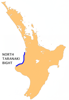
The North Taranaki Bight is a large bay that extends north and east from the north coast of Taranaki in New Zealand's North Island. The name is echoed by the South Taranaki Bight to the south of Cape Egmont.
Tuamarina River is a river in Marlborough in the South Island of New Zealand. It flows into the Wairau River just south of Tuamarina.

The Wairoa River in Northland New Zealand, sometimes referred to as The Northern Wairoa River, runs for 150 kilometres through the northern part of the North Auckland Peninsula. In the upper reaches, the river is formed from two separate rivers, the Mangakahia River and the Wairua River. The two streams meet to the northeast of Dargaville, becoming the Wairoa. It is the longest river in the Northland Region.

Tongaporutu is a settlement in northern Taranaki, in the North Island of New Zealand. It is located on State Highway 3 at the mouth of the Tongaporutu River, 15 kilometres south of Mokau.Tongaporutu is well known in New Zealand for its 'Three Sisters' rock formations and its Maori petroglyphs carved into cave rock walls. However,both the Maori rock carvings and the 'Three Sisters formations are constantly being eroded by the Tasman sea.
The Wonboyn River, an open youthful wave dominated barrier estuary or perennial stream, is located in the South Coast region of New South Wales, Australia.
The Omaumau River is a short river in the Auckland Region of New Zealand's North Island. It flows northwest to reach the Kaipara Harbour 20 kilometres (12 mi) northeast of Helensville.
The Paringa River is a river of the West Coast Region of New Zealand's South Island. It flows generally northwest from its origins in the Southern Alps southwest of Mount Hooker, reaching the Tasman Sea 10 kilometres southwest of Bruce Bay.
The Tahoranui River is a river of the Northland Region of New Zealand's North Island. It flows northeast from its origins near he settlement of Te Whau to reach the Pacific Ocean at Takou Bay, 10 kilometres north of Kerikeri.
The Tauranga Taupo River is a river of the Hawke's Bay and Waikato Regions of New Zealand's North Island. It flows northwest from its sources at the northern end of the Kaimanawa Range to reach the eastern shore of Lake Taupo close to the settlement of Rangiita, 12 kilometres (7 mi) northeast of Turangi.
The Tongaporutu River is a river of the Taranaki Region of New Zealand's North Island. It initially flows north from its origins near Tahora, turning west to reach the Tasman Sea coast close to the settlement of Tongaporutu, 15 kilometres south of Mokau.
The Topuni River is a river of the Northland Region of New Zealand's North Island. It flows generally south, with most of its length being through a drowned valley in the northeast of the Kaipara Harbour system. The Topuni River reaches the Oruawharo River — an arm of the Kaipara — 10 kilometres northwest of Wellsford.
The Waiaruhe River is a river of the Northland Region of New Zealand's North Island. It flows northeast from its origins close to Ngawha Springs to reach the northern Waitangi River five kilometres south of Kerikeri.
The Waiotama River is a river of the Northland Region of New Zealand's North Island. It flows northwest from its origins south of Maungatapere to reach the Wairua River 20 kilometres northeast of Dargaville.
The Waireia River is a river of the Auckland Region of New Zealand's North Island. Part of the Kaipara Harbour system, it flows north to meet the Oruawharo River 10 kilometres (6 mi) west of Wellsford.
The Waitoetoe River is a small river of the Taranaki Region of New Zealand's North Island. It flows close to the town of Urenui.
The Whenuakura River is a river of the Taranaki Region of New Zealand's North Island. It flows south from its origins northeast of Lake Rotorangi and reaches the coast five kilometres southeast of Patea.
Motutieke Island is the largest of the many low-lying marshy islands in the delta of the Waikato River, New Zealand's longest river. Stretching for some 7 kilometres (4 mi), and close to 1,000 metres (3,300 ft) wide at its widest, the island is in reality two islands separated by a shallow channel. The main body of the Waikato River flows to the southeast of the island, with narrow channels separating it to the north from the mainland of New Zealand's North Island. The smaller Puehunui Island lies close to the northwest.


