Related Research Articles

In aviation, instrument flight rules (IFR) is one of two sets of regulations governing all aspects of civil aviation aircraft operations; the other is visual flight rules (VFR).

Air traffic control (ATC) is a service provided by ground-based air traffic controllers who direct aircraft on the ground and through a given section of controlled airspace, and can provide advisory services to aircraft in non-controlled airspace. The primary purpose of ATC is to prevent collisions, organize and expedite the flow of traffic in the air, and provide information and other support for pilots.

Air traffic control specialists, abbreviated ATCs, are personnel responsible for the safe, orderly, and expeditious flow of air traffic in the global air traffic control system. Usually stationed in air traffic control centers and control towers on the ground, they monitor the position, speed, and altitude of aircraft in their assigned airspace visually and by radar, and give directions to the pilots by radio. Controllers apply separation rules to keep aircraft at a safe distance from each other and within proper airspace in their area of responsibility and move all aircraft safely and efficiently through their assigned sector of airspace, as well as on the ground. Because controllers have an incredibly large responsibility while on duty and make countless real-time decisions on a daily basis, the ATC profession is consistently regarded around the world as one of the most mentally challenging careers, and can be notoriously stressful depending on many variables. Many controllers, however, cite high salaries, and a large, unique, and privileged degree of autonomy as major advantages of their jobs.
Aviation is the design, development, production, operation, and use of aircraft, especially heavier-than-air aircraft. Articles related to aviation include:
In aviation, a controlled flight into terrain is an accident in which an airworthy aircraft, fully under pilot control, is unintentionally flown into the ground, a body of water or other obstacle. In a typical CFIT scenario, the crew is unaware of the impending collision until impact, or it is too late to avert. The term was coined by engineers at Boeing in the late 1970s.

A traffic alert and collision avoidance system (TCAS, pronounced TEE-kas), also known as an Airborne Collision Avoidance System (ACAS), is an aircraft collision avoidance system designed to reduce the incidence of mid-air collision (MAC) between aircraft. It monitors the airspace around an aircraft for other aircraft equipped with a corresponding active transponder, independent of air traffic control, and warns pilots of the presence of other transponder-equipped aircraft which may present a threat of MAC. It is a type of airborne collision avoidance system mandated by the International Civil Aviation Organization to be fitted to all aircraft with a maximum take-off mass (MTOM) of over 5,700 kg (12,600 lb) or authorized to carry more than 19 passengers. CFR 14, Ch I, part 135 requires that TCAS I be installed for aircraft with 10-30 passengers and TCAS II for aircraft with more than 30 passengers. ACAS/TCAS is based on secondary surveillance radar (SSR) transponder signals, but operates independently of ground-based equipment to provide advice to the pilot on potentially conflicting aircraft.
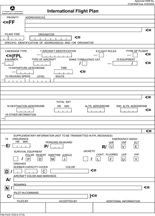
Flight plans are documents filed by a pilot or flight dispatcher with the local Air Navigation Service Provider prior to departure which indicate the plane's planned route or flight path. Flight plan format is specified in ICAO Doc 4444. They generally include basic information such as departure and arrival points, estimated time en route, alternate airports in case of bad weather, type of flight, the pilot's information, number of people on board, and information about the aircraft itself. In most countries, flight plans are required for flights under IFR, but may be optional for flying VFR unless crossing international borders. Flight plans are highly recommended, especially when flying over inhospitable areas such as water, as they provide a way of alerting rescuers if the flight is overdue. In the United States and Canada, when an aircraft is crossing the Air Defense Identification Zone (ADIZ), either an IFR or a special type of VFR flight plan called a DVFR flight plan must be filed. For IFR flights, flight plans are used by air traffic control to initiate tracking and routing services. For VFR flights, their only purpose is to provide needed information should search and rescue operations be required, or for use by air traffic control when flying in a "Special Flight Rules Area."

In aviation, an instrument approach or instrument approach procedure (IAP) is a series of predetermined maneuvers for the orderly transfer of an aircraft operating under instrument flight rules from the beginning of the initial approach to a landing, or to a point from which a landing may be made visually. These approaches are approved in the European Union by EASA and the respective country authorities and in the United States by the FAA or the United States Department of Defense for the military. The ICAO defines an instrument approach as "a series of predetermined maneuvers by reference to flight instruments with specific protection from obstacles from the initial approach fix, or where applicable, from the beginning of a defined arrival route to a point from which a landing can be completed and thereafter, if landing is not completed, to a position at which holding or en route obstacle clearance criteria apply."
The European Organisation for the Safety of Air Navigation, commonly known as Eurocontrol, is an international organisation working to achieve safe and seamless air traffic management across Europe. Founded in 1963, Eurocontrol currently has 42 member states with headquarters in Brussels, Belgium. It has several local sites as well, including an Innovation Hub in Brétigny-sur-Orge, France, the Aviation Learning Centre (ALC) in Luxembourg, and the Maastricht Upper Area Control Centre (MUAC) in Maastricht, the Netherlands. The organisation employs approximately two thousand people, and operates with an annual budget in excess of half a billion euros.
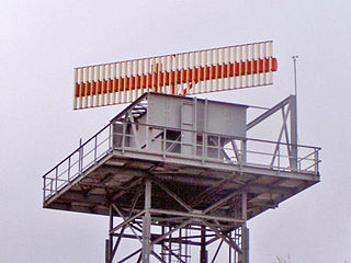
Secondary surveillance radar (SSR) is a radar system used in air traffic control (ATC), that unlike primary radar systems that measure the bearing and distance of targets using the detected reflections of radio signals, relies on targets equipped with a radar transponder, that reply to each interrogation signal by transmitting encoded data such as an identity code, the aircraft's altitude and further information depending on its chosen mode. SSR is based on the military identification friend or foe (IFF) technology originally developed during World War II; therefore, the two systems are still compatible. Monopulse secondary surveillance radar (MSSR), Mode S, TCAS and ADS-B are similar modern methods of secondary surveillance.

An airborne collision avoidance system operates independently of ground-based equipment and air traffic control in warning pilots of the presence of other aircraft that may present a threat of collision. If the risk of collision is imminent, the system recommends a maneuver that will reduce the risk of collision. ACAS standards and recommended practices are mainly defined in annex 10, volume IV, of the Convention on International Civil Aviation. Much of the technology being applied to both military and general aviation today has been undergoing development by NASA and other partners since the 1980s.
Required navigation performance (RNP) is a type of performance-based navigation (PBN) that allows an aircraft to fly a specific path between two 3D-defined points in space.
The Future Air Navigation System (FANS) is an avionics system which provides direct data link communication between the pilot and the air traffic controller. The communications include air traffic control clearances, pilot requests and position reporting. In the FANS-B equipped Airbus A320 family aircraft, an Air Traffic Services Unit (ATSU) and a VHF Data Link radio (VDR3) in the avionics rack and two data link control and display units (DCDUs) in the cockpit enable the flight crew to read and answer the controller–pilot data link communications (CPDLC) messages received from the ground.
Short-term conflict alert (STCA) is an automated warning system for air traffic controllers (ATCO). It is a ground-based safety net intended to assist the controller in preventing collision between aircraft by generating, in a timely manner, an alert of a potential or actual infringement of separation minima.

A runway incursion is an aviation incident involving improper positioning of vehicles or people on any airport runway or its protected area. When an incursion involves an active runway being used by arriving or departing aircraft, the potential for a collision hazard or instrument landing system (ILS) interference can exist. At present, various runway safety technologies and processes are commonly employed to reduce the risk and potential consequences of such an event.

A low-level windshear alert system (LLWAS) measures average surface wind speed and direction using a network of remote sensor stations, situated near runways and along approach or departure corridors at an airport. Wind shear is the generic term for wind differences over an operationally short distance which encompass meteorological phenomena including gust fronts, microbursts, vertical shear, and derechos.
Common ARTS is an air traffic control computer system that air traffic controllers use to track aircraft.

Automatic Dependent Surveillance–Broadcast (ADS-B) is an aviation surveillance technology and form of electronic conspicuity in which an aircraft determines its position via satellite navigation or other sensors and periodically broadcasts its position and other related data, enabling it to be tracked. The information can be received by air traffic control ground-based or satellite-based receivers as a replacement for secondary surveillance radar (SSR). Unlike SSR, ADS-B does not require an interrogation signal from the ground or from other aircraft to activate its transmissions. ADS-B can also receive point-to-point by other nearby equipped ADS-B equipped aircraft to provide traffic situational awareness and support self-separation.
The TopSky system is a computerised air traffic control and management solution developed by Thales Air Systems. It utilises a distributed computing architecture and is capable of integrating geographically dispersed air traffic control units within a Flight Information Region into a single coherent system.

In aviation, a visual approach is an approach to a runway at an airport conducted under instrument flight rules (IFR) but where the pilot proceeds by visual reference and clear of clouds to the airport. The pilot must at all times have either the airport or the preceding aircraft in sight. This approach must be authorized and under the control of the appropriate air traffic control (ATC) facility. The International Civil Aviation Organization (ICAO) definition adds that the visual approach can commence when "either part or all of an instrument approach is not completed", varying only slightly from the Federal Aviation Administration regulation and is essentially identical.
References
- ↑ "EUROCONTROL Specification for Minimum Safe Altitude Warning" (PDF). 0.9. Eurocontrol. 19 May 2009. Retrieved 2010-05-24.
- ↑ Rules of the Air and Air Traffic Services. ICAO. Doc 4444-RAC/501.
- ↑ "Chapter 2. The Air Traffic Control System". Instrument Flying Handbook (PDF) (FAA-H-8083-15B ed.). Federal Aviation Administration Flight Standards Service. 2012. p. 5. ISBN 979-8776640544.
 This article incorporates text from this source, which is in the public domain .