Related Research Articles
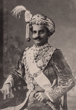
Chamarajendra Wadiyar X was the twenty-third Maharaja of Mysore between 1868 and 1894.

Mysore district, officially Mysuru district, is an administrative district located in the southern part of the state of Karnataka, India. It is the administrative headquarters of Mysore division. Chamarajanagar District was carved out of the original larger Mysore District in the year 1998. The district is bounded by Chamrajanagar district to the southeast, Mandya district to the east and northeast, Kerala state to the south, Kodagu district to the west, and Hassan district to the north.

SirMirza Muhammad IsmailAmin-ul-Mulq was an Indian statesman and police officer who served as the Diwan of Mysore, Jaipur, and Hyderabad.
Cubbon Park, officially Sri Chamarajendra Park, is a landmark park in Bengaluru, located in the heart of the city in the Central Administrative Area. Originally created in 1870 under Major General Richard Sankey, then British Chief Engineer of Mysore State, it covered an area of 100 acres (0.40 km2). Subsequent expansion has since taken place and the park's area is now reported to be 300 acres (1.2 km2). It has a rich recorded history of abundant flora and fauna plantations coupled with numerous impressive and aesthetically located buildings and statues of famous personages, in its precincts.

Hinkal is a Census town situated at the intersection of Hunsur Road aka NH275 and Ring Road aka NH 275K in Mysore city outskirts of Karnataka, India. It is the most populous census town in Mysore district. The nearest railway station located is Mysore Junction railway station.

Bangalore City Railway Station, officially Krantivira Sangolli Rayanna Bengaluru Station, commonly known as KSR Bengaluru Station, Bengaluru City Railway Station or Majestic Railway station, is the main railway station serving the city of Bangalore, Karnataka, India. It is the busiest railway station in South Western Railway zone of Indian Railways, and is the only station classified under NSG1 category in the zone.
The dewan of Mysore, sometimes spelled diwan of Mysore, was the de facto chief executive officer of the Government of Mysore, ex officio chairman of the Dewan's Council, and the prime minister and royal adviser to the maharaja of Mysore. The role evolved in title and duties since the foundation of the fiefdom of Mysore in 1350 and its proper reformation into a kingdom in the following centuries until the kingdom's full abolishment in 1950. With the constitution of India into a republic in 1950, the position was replaced by Chief Minister of Mysore.

D. Devaraj Urs Road is the most prominent shopping street of Mysore city in Karnataka state, India. This street is also the center of the downtown or the Central business district area in the city. In post office parlance, Devaraj Urs road is known as Mysore One.

Dewan's Road, officially known as Seshadri Iyer Road is an important main street in downtown Mysore city, Karnataka state, India.
Mandi Mohalla, K.T.Street or Ashoka Road, is a suburb of Mysore city in Karnataka state of India.

Krishna Murthy Puram is an urban commercial and residential suburb of Mysore city in Karnataka state, India.

Krishnaraja Boulevard is an important street of Mysore city in Karnataka state of India.
Akshaya Bhandar is a suburb of Mysore in Karnataka, India.

Chamaraja Road or Chamarajendra double Road is an important main street in downtown Mysore city, Karnataka state, India.
Agrahara Circle, officially known as N. Madhava Rao Circle, is a street circle and a suburb in the southern Indian city of Mysore in Karnataka.
Agrahara is an area of the city of Mysore in the state of Karnataka in India. Famous locations in Agrahara include Mysore Palace as well as several gardens and historic temples. The area is bounded by Albert Victor Road to the North, MG Road to the South, Bengaluru-Nilgiri Road to the East, and Cheluvamba Agrahara Road to the West. The term agrahara or agraharam refers to a grant of land and agricultural income made by royalty to Brahmins in pre-independence South India. Though the Mysuru Agrahara is commonly referred to as a single neighbourhood, it is a composite of multiple adjacent smaller settlements built over time.
M. Kantharaj Urs Road is a road in Mysore city, Karnataka state, India.
Jayalakshmipuram is an urban commercial and residential suburb of Mysore city in Karnataka state, India. Residence of Noted Kannada Poet Javaregowda is located in Jayalakshmipuram.
Chamundipura is a suburb of Mysore city in Karnataka state, India.
Lakshmipura is a suburb of Mysore city in Karnataka state, India.
References
- ↑ "New vehicle parking and no-parking zones". Star of Mysore. 1 January 2022. Retrieved 8 March 2022.
- ↑ "Band House again..." Star of Mysore. 21 February 2021. Retrieved 8 March 2022.
- ↑ "Music to ears: Daily Police Band at Palace". Star of Mysore. 3 January 2022. Retrieved 8 March 2022.
- ↑ "Landmarks for Dewans and their services forgotten". Star of Mysore. 2 November 2020. Retrieved 8 March 2022.
- ↑ "Landmarks for Dewans and their services forgotten". Star of Mysore. 2 November 2020. Retrieved 8 March 2022.
- ↑ "'Tai Nadu' P.R. Ramaiah A family story". Star of Mysore. 12 November 2021. Retrieved 8 March 2022.
- ↑ "Bad roads and plight of citizens". Star of Mysore. 3 October 2021. Retrieved 8 March 2022.
- ↑ "Commuters' plea for 'bus shelter' on Mirza Road in Mysuru – Mysuru Today" . Retrieved 8 March 2022.
- ↑ "Mysuru City Police Commissionerate gets its own office 31 years after it was set up". The Hindu. 24 November 2020. ISSN 0971-751X . Retrieved 8 March 2022.
12°18′25″N76°39′46″E / 12.30682368415014°N 76.66280793207153°E
| | This Indian road or road transport-related article is a stub. You can help Wikipedia by expanding it. |