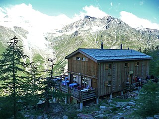
The Mischabel Hut (German: Mischabelhütte) is a mountain hut of the Academic Alpine Club of Zurich, located west of Saas Fee in the canton of Valais. It lies at a height of 3,340 metres (10,960 ft) above sea level near the Hohbalmgletscher glacier, on the eastern flanks of the Dom and the Lenzspitze in the Mischabel group.
German is a West Germanic language that is mainly spoken in Central Europe. It is the most widely spoken and official or co-official language in Germany, Austria, Switzerland, South Tyrol (Italy), the German-speaking Community of Belgium, and Liechtenstein. It is also one of the three official languages of Luxembourg and a co-official language in the Opole Voivodeship in Poland. The languages which are most similar to German are the other members of the West Germanic language branch: Afrikaans, Dutch, English, the Frisian languages, Low German/Low Saxon, Luxembourgish, and Yiddish. There are also strong similarities in vocabulary with Danish, Norwegian and Swedish, although those belong to the North Germanic group. German is the second most widely spoken Germanic language, after English.
A mountain hut is a building located high in the mountains, generally accessible only by foot, intended to provide food and shelter to mountaineers, climbers and hikers. Mountain huts are usually operated by an Alpine Club or some organisation dedicated to hiking or mountain recreation.
The Dom is a mountain of the Pennine Alps, located between Randa and Saas-Fee in the canton of Valais. With its 4,545 m (14,911 ft) summit it is the third highest mountain in the Alps and the second highest in Switzerland, after Monte Rosa. The Dom is the main summit of the Mischabel group, which is the highest massif lying entirely in Switzerland.
The hut is accessible to experienced hikers from Saas Fee (4 hours), with a marked trail and fixed ropes. The Mischabel Hut is used to climb the Lenzspitze, the Nadelhorn and the Hohberghorn.
The Nadelhorn is a mountain in the Pennine Alps in Switzerland. It is the highest point on the Nadelgrat, a high-level ridge running roughly north–south above the resort of Saas-Fee to the east, and the Mattertal to the west. Its three ridges join to form a sharp-pointed summit, which looks like a needle when seen from the north. The other summits on the Nadelgrat are the Stecknadelhorn and Hohberghorn.
The Hohberghorn is a mountain in the Pennine Alps in Switzerland. It lies towards the northern end of the Nadelgrat, a high-level ridge running roughly north–south, north of the Dom, above the resort of Saas-Fee to the east, and the Mattertal to the west.
The European Graduate School (EGS) is a private graduate school that operates in two locations: Saas-Fee, Switzerland, and Valletta, Malta.
Saas-Fee is the main village in the Saastal, or the Saas Valley, and is a municipality in the district of Visp in the canton of Valais in Switzerland. The villages in its neighborhood are Saas-Almagell, Saas-Grund and Saas-Balen.
The Haute Route, is the name given to a route undertaken on foot or by ski touring between Chamonix in France and Zermatt in Switzerland.
The Monte Rosa Tour is a circular hiking trail through the Swiss & Italian Alps around Monte Rosa (4634m). The tour also encircles the Dom in the Mischabel range.
The Saastal or the Saas Valley is an alpine valley in the district of Visp, in the eastern part of the Canton of Valais, Switzerland. It is the valley of the river Saaser Vispa. It is separated from the Mattertal to the west by the Mischabel massif. Villages in the valley are, upstream, Eisten, Saas-Balen, Saas-Grund, Saas-Fee and Saas-Almagell.
The Weissmies 4,017 m (13,179 ft) is a mountain in the Pennine Alps in the canton of Valais in Switzerland near the village of Saas-Fee. It is the easternmost four-thousander of its range.
The district of Visp is a district in the Canton of Valais in southern Switzerland. It has a population of 28,381.
Saas-Grund is a municipality in the district of Visp in the canton of Valais in Switzerland. It lies east of Lenzspitze and Dom.
The Metro Alpin is an underground funicular situated above the Swiss town of Saas Fee, in the canton of Valais. Opened in 1984, it links the Felskinn cable-car station on the shore of the Fee Glacier to the Mittelallalin in the north flank of the Allalinhorn. The Felskinn–Mittelallalin Tunnel has a length of 1,749 metres (5,738 ft), with an altitude difference of 476 metres (1,562 ft) between the two stations.
The Lenzspitze is a 4,294-metre (14,088 ft) mountain in the Pennine Alps in Switzerland. It is the southernmost peak on the Nadelgrat, a high-level ridge running roughly north–south, north of Dom in the Mischabel range, above the resort of Saas Fee to the east, and the Mattertal to the west.
The Stecknadelhorn is a mountain in the Pennine Alps in Switzerland. It lies on the Nadelgrat, a high-level ridge running roughly north–south above the resort of Saas Fee to the east, and the Mattertal to the west.
The Alphubel is a mountain of the Swiss Pennine Alps, located between the valleys of Zermatt and Saas in the canton of Valais. It is part of the Mischabel range, which culminates at the Dom. The summit of the Alphubel consists of a large ice-covered plateau, part of the Fee Glacier on its east side. The west side of the mountain is more rocky and much steeper. It overlooks the Weingartensee.
Alexander Burgener was a Swiss mountain guide and the first ascentionist of many mountains and new routes in the western Alps during the silver age of alpinism.
Edward Shirley Kennedy (1817–1898) was an English mountaineer and author, and a founding member of the Alpine Club.
Hohsaas is a cable car station and a ski area in the Pennine Alps above Saas Grund in Valais.
The Konkordia Hut is a mountain hut of the Swiss Alpine Club, located north of Fieschertal in the canton of Valais. The hut lies above Konkordiaplatz, the point of convergence of several glaciers in the great Aletsch Glacier system of the Bernese Alps. It is located at a height of 2,850 metres above sea level, at the foot of the Fülbärg.
The Britannia Hut is a mountain hut of the Swiss Alpine Club, located south of Saas-Almagell in the canton of Valais. The hut lies at a height of 3,030 metres above sea level, at the foot of the Allalinhorn near the Allalin Glacier, in the Mischabel massif. It is a starting point for the ascents of Strahlhorn, Rimpfischhorn and Allalinhorn.
The Europa Hut is a mountain hut located in the Mattertal above Randa in the Mischabel range at 2,265 m, owned by the Swiss Alpine Club. It lies on the Grächen-Zermatt high trail, called Europaweg. From the hut a trail leads to the Dom Hut, on the normal route to the Dom.
Coordinates: 46°06′33″N7°53′20″E / 46.10917°N 7.88889°E
A geographic coordinate system is a coordinate system that enables every location on Earth to be specified by a set of numbers, letters or symbols. The coordinates are often chosen such that one of the numbers represents a vertical position and two or three of the numbers represent a horizontal position; alternatively, a geographic position may be expressed in a combined three-dimensional Cartesian vector. A common choice of coordinates is latitude, longitude and elevation. To specify a location on a plane requires a map projection.