Related Research Articles

An emergency position-indicating radiobeacon (EPIRB) is a type of emergency locator beacon for commercial and recreational boats, a portable, battery-powered radio transmitter used in emergencies to locate boaters in distress and in need of immediate rescue. In the event of an emergency, such as a ship sinking or medical emergency onboard, the transmitter is activated and begins transmitting a continuous 406 MHz distress radio signal, which is used by search-and-rescue teams to quickly locate the emergency and render aid. The signal is detected by satellites operated by an international consortium of rescue services, COSPAS-SARSAT, which can detect emergency beacons anywhere on Earth transmitting on the distress frequency of 406 MHz. The satellites calculate the position or utilize the GPS coordinates of the beacon and quickly passes the information to the appropriate local first responder organization, which performs the search and rescue. As Search and Rescue approach the search areas, they use Direction Finding (DF) equipment to locate the beacon using the 121.5 MHz homing signal, or in newer EPIRBs, the AIS location signal. The basic purpose of this system is to help rescuers find survivors within the so-called "golden day" during which the majority of survivors can usually be saved. The feature distinguishing a modern EPIRB, often called GPIRB, from other types of emergency beacon is that it contains a GPS receiver and broadcasts its position, usually accurate within 100 m (330 ft), to facilitate location. Previous emergency beacons without a GPS can only be localized to within 2 km (1.2 mi) by the COSPAS satellites and relied heavily upon the 121.5 MHz homing signal to pin-point the beacons location as they arrived on scene.
A distress signal, also known as a distress call, is an internationally recognized means for obtaining help. Distress signals are communicated by transmitting radio signals, displaying a visually observable item or illumination, or making a sound audible from a distance.
The Global Maritime Distress and Safety System (GMDSS) is a worldwide system for automated emergency signal communication for ships at sea developed by the United Nations' International Maritime Organization (IMO) as part of the SOLAS Convention.

The Indian National Satellite System or INSAT, is a series of multipurpose geostationary satellites launched by the Indian Space Research Organisation (ISRO) to satisfy telecommunications, broadcasting, meteorology, and search and rescue operations. Commissioned in 1983, INSAT is the largest domestic communication system in the Indo-Pacific Region. It is a joint venture of the Department of Space, Department of Telecommunications, India Meteorological Department, All India Radio and Doordarshan. The overall coordination and management of INSAT system rests with the Secretary-level INSAT Coordination Committee.
The International Cospas-Sarsat Programme is a satellite-aided search and rescue (SAR) initiative. It is organized as a treaty-based, nonprofit, intergovernmental, humanitarian cooperative of 45 nations and agencies. It is dedicated to detecting and locating emergency locator radio beacons activated by persons, aircraft or vessels in distress, and forwarding this alert information to authorities that can take action for rescue. Member countries support the distribution of distress alerts using a constellation of around 65 satellites orbiting the Earth which carry transponders and signal processors capable of locating an emergency beacon anywhere on Earth transmitting on the Cospas-Sarsat frequency of 406 MHz.
The National Search and Rescue Plan or National SAR Plan is a policy document of the US government that establishes the responsibilities for search and rescue in the domestic United States, as well as areas where the US has international commitments.

Maspalomas Station is an INTA-operated, ESTRACK radio antenna ground station for communication with spacecraft located at the southern area of Gran Canaria island, on the INTA campus. It is situated on the Montaña Blanca hill and is visible from the coastal resort of Meloneras, close to Maspalomas. It was originally established in the 1960s to support NASA's nascent human spaceflight program.
The Space & Upper Atmosphere Research Commission, commonly referred to as SUPARCO, is the national space agency of Pakistan.

The United Kingdom's Aeronautical Rescue Coordination Centre (ARCC) is based at the Joint Rescue Coordination Centre (JRCC), Fareham, Hampshire.
An international distress frequency is a radio frequency that is designated for emergency communication by international agreement.
The Joint Rescue Coordination Centre of Southern Norway or JRCC SN is a rescue coordination center located in Sola which is responsible for coordinating major search and rescue (SAR) operations in Norway south of the 65th parallel north. Established in 1970, it is a government agency subordinate to the Ministry of Justice and Public Security and led by the Chief of Police of Rogaland Police District. The agency has twenty-three employees and has at least two rescue controllers at work at any time.
The Polar-orbiting Operational Environmental Satellite (POES) is a constellation of polar orbiting weather satellites funded by the National Oceanic and Atmospheric Administration (NOAA) and the European Organisation for the Exploitation of Meteorological Satellites (EUMETSAT) with the intent of improving the accuracy and detail of weather analysis and forecasting. The spacecraft were provided by NASA and the European Space Agency (ESA), and NASA's Goddard Space Flight Center oversaw the manufacture, integration and test of the NASA-provided TIROS satellites. The first polar-orbiting weather satellite launched as part of the POES constellation was the Television Infrared Observation Satellite-N (TIROS-N), which was launched on 13 October 1978. The final spacecraft, NOAA-19, was launched on 6 February 2009. The ESA-provided MetOp satellite operated by EUMETSAT utilize POES-heritage instruments for the purpose of data continuity. The Joint Polar Satellite System, which was launched on 18 November 2017, is the successor to the POES Program.
NOAA-13, also known as NOAA-I before launch, was an American weather satellite operated by the National Oceanic and Atmospheric Administration (NOAA). NOAA-I continued the operational, polar orbiting, meteorological satellite series operated by the National Environmental Satellite System (NESS) of the National Oceanic and Atmospheric Administration (NOAA). NOAA-I continued the series (fifth) of Advanced TIROS-N (ATN) spacecraft begun with the launch of NOAA-8 (NOAA-E) in 1983. NOAA-I was in an afternoon equator-crossing orbit and was intended to replace the NOAA-11 (NOAA-H) as the prime afternoon (14:00) spacecraft.
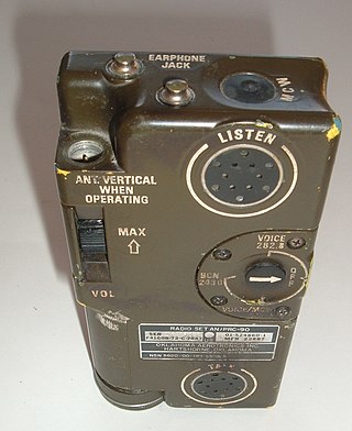
Survival radios are carried by pilots and search and rescue teams to facilitate rescue in an emergency. They are generally designed to transmit on international distress frequencies. Maritime systems have been standardized under the Global Maritime Distress Safety System. Civil and military organisation's utilized different frequencies to communicate and no infringement on either sector would take place. For emergencies involving civilian aircraft, the radio frequency used is VHF 121.5 MHz and for military aircraft incidents, the frequency used is UHF 243 MHz.
The Joint Rescue Coordination Centre Trenton is a rescue coordination centre operated by the Royal Canadian Air Force (RCAF) and the Canadian Coast Guard (CCG).
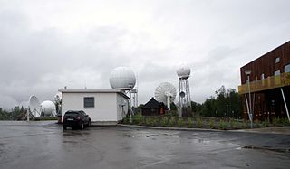
Tromsø Satellite Station, until 1988 known as Tromsø Telemetry Station, is a satellite earth station located in Tromsø, Norway. The facility is owned by Kongsberg Satellite Services (KSAT), a joint venture between the Kongsberg Group and the Norwegian Space Centre (NSC). In addition to hosting its own antennas serving thirty satellites, TSS acts as the center-point of KSAT's operations and provides backbone services for the high Arctic Svalbard Satellite Station (SvalSat) and the Antarctic Troll Satellite Station (TrollSat).
An emergency locator beacon is a radio beacon, a portable battery powered radio transmitter, used to locate airplanes, vessels, and persons in distress and in need of immediate rescue. Various types of emergency locator beacons are carried by aircraft, ships, vehicles, hikers and cross-country skiers. In case of an emergency, such as the aircraft crashing, the ship sinking, or a hiker becoming lost, the transmitter is deployed and begins to transmit a continuous radio signal, which is used by search and rescue teams to quickly find the emergency and render aid. The purpose of all emergency locator beacons is to help rescuers find survivors within the so-called "golden day", the first 24 hours following a traumatic event, during which the majority of survivors can usually be saved.
NOAA-14, also known as NOAA-J before launch, was an American weather satellite operated by the National Oceanic and Atmospheric Administration (NOAA). NOAA-14 continued the third-generation operational, Polar Orbiting Environmental Satellite (POES) series operated by the National Environmental Satellite Service (NESS) of the National Oceanic and Atmospheric Administration (NOAA). NOAA-14 continued the series of Advanced TIROS-N (ATN) spacecraft begun with the launch of NOAA-8 (NOAA-E) in 1983.
The National Emergency Management Agency is an agency in Nigeria. The agency focuses on disaster management in all parts of the country. The agency was established in 1999, and functions to formulate policies relating to disaster management in Nigeria.
References
- ↑ "MCC Description". Archived from the original on 2007-10-13. Retrieved 2007-10-01.
- ↑ "Summary Status". Archived from the original on 2007-10-13. Retrieved 2007-09-29.