A Mississippi River Pilot is responsible for guiding ships along the Mississippi River, including across the bar from the Gulf of Mexico, through the shifting sandbars and passages at the mouth, and upriver to New Orleans and Baton Rouge.
On the Lower Mississippi River, the Associated Branch Pilots supplies River Pilots between the Gulf of Mexico and Pilottown, Louisiana. The Crescent River Port Pilots Association supplies River Pilots between Pilottown and New Orleans, Louisiana, and the New Orleans-Baton Rouge Steamship Pilots Association supplies River Pilots between New Orleans and Baton Rouge, Louisiana.
The Associated Federal Pilots and Docking Masters of Louisiana are pilots who deal strictly with US Flagged vessels and operate from Southwest Pass to Baton Rouge, the longest transit of the 4 pilot associations in the river.
The Mississippi River is the primary river and second-longest river of the largest drainage basin in the United States. From its traditional source of Lake Itasca in northern Minnesota, it flows generally south for 2,340 miles (3,766 km) to the Mississippi River Delta in the Gulf of Mexico. With its many tributaries, the Mississippi's watershed drains all or parts of 32 U.S. states and two Canadian provinces between the Rocky and Appalachian mountains. The main stem is entirely within the United States; the total drainage basin is 1,151,000 sq mi (2,980,000 km2), of which only about one percent is in Canada. The Mississippi ranks as the thirteenth-largest river by discharge in the world. The river either borders or passes through the states of Minnesota, Wisconsin, Iowa, Illinois, Missouri, Kentucky, Tennessee, Arkansas, Mississippi, and Louisiana.
Baton Rouge is the capital city of the U.S. state of Louisiana. Located on the eastern bank of the Mississippi River, it had a population of 227,470 as of 2020; it is the seat of Louisiana's most populous parish (county-equivalent), East Baton Rouge Parish, and the center of Louisiana's second-largest metropolitan area and city, Greater Baton Rouge.
Pilottown is an unincorporated community in Plaquemines Parish, Louisiana, United States. It serves as a base for river pilots to guide ships across the bar and up and down the Mississippi River. As of 2020, the population of the community is 0.
The Florida Parishes, on the east side of the Mississippi River—an area also known as the Northshore or Northlake region—are eight parishes in the southeastern portion of the U.S. state of Louisiana.
The Port of South Louisiana extends 54 miles (87 km) along the Mississippi River between New Orleans, Louisiana and Baton Rouge, Louisiana, centering approximately at LaPlace, Louisiana, which serves as the Port's headquarters location.
The Old River Control Structure is a floodgate system in a branch of the Mississippi River in central Louisiana. It regulates the flow of water from the Mississippi into the Atchafalaya River, thereby preventing the Mississippi River from changing course. Completed in 1963, the complex was built by the U.S. Army Corps of Engineers in a side channel of the Mississippi known as "Old River", between the Mississippi's current channel and the Atchafalaya Basin, a former channel of the Mississippi.
The capture of New Orleans during the American Civil War was a turning point in the war that precipitated the capture of the Mississippi River. Having fought past Forts Jackson and St. Philip, the Union was unopposed in its capture of the city itself.
The Lower Mississippi River is the portion of the Mississippi River downstream of Cairo, Illinois. From the confluence of the Ohio River and the Middle Mississippi River at Cairo, the Lower flows just under 1000 miles (1600 km) to the Gulf of Mexico. It is the most heavily travelled component of the Mississippi River System.
Airline Highway is a divided highway in the U.S. state of Louisiana, built in stages between 1925 and 1953 to bypass the older Jefferson Highway. It runs 115.6 miles (186.0 km), carrying U.S. Highway 61 from New Orleans northwest to Baton Rouge and U.S. Highway 190 from Baton Rouge west over the Mississippi River on the Huey P. Long Bridge. US 190 continues west towards Opelousas on an extension built at roughly the same time.
Louisiana Highway 1 (LA 1) is a state highway in Louisiana. At 431.88 miles (695.04 km), it is the longest numbered highway of any class in Louisiana. It runs diagonally across the state, connecting the oil and gas fields near the island of Grand Isle with the northwest corner of the state, north of Shreveport.
Louisiana Highway 47 (LA 47) is a state highway located in southeastern Louisiana. It runs 15.91 miles (25.60 km) in a general southeast to northwest direction from the Mississippi River levee in Chalmette to the intersection of Hayne Boulevard and Downman Road in New Orleans.
The Battle of Baton Rouge was a ground and naval battle in the American Civil War fought in East Baton Rouge Parish, Louisiana, on August 5, 1862. The Union victory halted Confederate attempts to recapture the capital city of Louisiana.
Bayou Manchac is an 18-mile-long (29 km) bayou in southeast Louisiana, USA. First called the Iberville River by its French discoverers, the bayou was once a very important waterway linking the Mississippi River to the Amite River. East Baton Rouge Parish lies on its northern side, while its southern side is divided between Ascension Parish and Iberville Parish. The large unincorporated community of Prairieville and the city of St. Gabriel both lie on its southern side.
La Balize, Louisiana was a French fort and settlement near the mouth of the Mississippi River, in what later became Plaquemines Parish. The village's name meant "seamark." La Balize was historically and economically important for overseeing the river. It was rebuilt several times because of hurricane damage. The active delta lobe of the river's mouth is called the Balize Delta, after the settlement, or the Birdfoot Delta, because of its shape.
U.S. Highway 11 (US 11) is a part of the United States Numbered Highway System that spans 1,645 miles (2,647 km) from New Orleans, Louisiana, to Rouses Point, New York. Within the state of Louisiana, the highway travels 31 miles (50 km) from the national southern terminus at US 90 in New Orleans to the Mississippi state line south of Picayune.
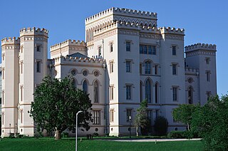
The foundation of Baton Rouge, Louisiana, dates to 1721, at the site of a bâton rouge or "red stick" Muscogee boundary marker. It became the state capital of Louisiana in 1849.
U.S. Highway 65 (US 65) is a part of the United States Numbered Highway System that spans 966 miles (1,555 km) from Clayton, Louisiana to Albert Lea, Minnesota. Within the state of Louisiana, the highway travels 100.77 miles (162.17 km) from the national southern terminus at US 425/LA 15 in Clayton to the Arkansas state line north of Lake Providence.
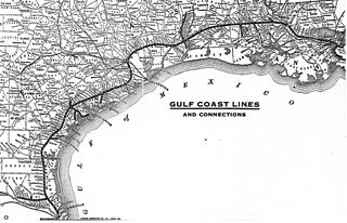
The Gulf Coast Lines was the name of a railroad system comprising three principal railroads, as well as some smaller ones, that stretched from New Orleans, Louisiana, via Baton Rouge and Houston to Brownsville, Texas. Originally chartered as subsidiaries of the Frisco Railroad, the system became independent in 1916 and was purchased by the Missouri Pacific Railroad in 1925.
The National Weather Service Weather Forecast Office New Orleans/Baton Rouge, Louisiana is a National Weather Service office located in Slidell, Louisiana.
Paleontology in Louisiana refers to paleontological research occurring within or conducted by people from the U.S. state of Louisiana. Outcrops of fossil-bearing sediments and sedimentary rocks within Louisiana are quite rare. In part, this is because Louisiana’s semi-humid climate results in the rapid weathering and erosion of any exposures and the growth of thick vegetation that conceal any fossil-bearing strata. In addition, Holocene alluvial sediments left behind by rivers like the Mississippi, Red, and Ouachita, as well as marsh deposits, cover about 55% of Louisiana and deeply bury local fossiliferous strata.
This page is based on this Wikipedia article Text is available under the CC BY-SA 4.0 license; additional terms may apply. Images, videos and audio are available under their respective licenses.