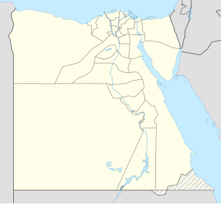
The geography of Egypt relates to two regions: North Africa and Southwest Asia.

The Nile is a major north-flowing river in northeastern Africa, and is the longest river in Africa and the disputed longest river in the world, as the Brazilian government claims that the Amazon River is longer than the Nile. The Nile, which is about 6,650 km (4,130 mi) long, is an "international" river as its drainage basin covers eleven countries, namely, Tanzania, Uganda, Rwanda, Burundi, the Democratic Republic of the Congo, Kenya, Ethiopia, Eritrea, South Sudan, Republic of the Sudan and Egypt. In particular, the Nile is the primary water source of Egypt and Sudan.
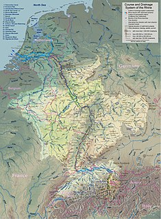
The Rhine is one of the major European rivers, which has its sources in Switzerland and flows in a mostly northerly direction through Germany and the Netherlands, emptying into the North Sea. The river begins in the Swiss canton of Graubünden in the southeastern Swiss Alps, forms part of the Swiss-Liechtenstein, Swiss-Austrian, Swiss-German and then the Franco-German border, then flows through the German Rhineland and the Netherlands and eventually empties into the North Sea.

A floodplain or flood plain is an area of land adjacent to a stream or river which stretches from the banks of its channel to the base of the enclosing valley walls, and which experiences flooding during periods of high discharge. The soils usually consist of clays, silts, and sands deposited during floods.

The Zambezi is the fourth-longest river in Africa, the longest east-flowing river in Africa and the largest flowing into the Indian Ocean from Africa. The area of its basin is 1,390,000 square kilometres (540,000 sq mi), slightly less than half of the Nile's. The 2,574-kilometre-long river (1,599 mi) arises in Zambia and flows through eastern Angola, along the north-eastern border of Namibia and the northern border of Botswana, then along the border between Zambia and Zimbabwe to Mozambique, where it crosses the country to empty into the Indian Ocean.

The Brahmaputra is one of the major rivers of Asia, a trans-boundary river which flows through China, India and Bangladesh. As such, it is known by various names in the region: Assamese: লুইত luit[luɪt], ব্ৰহ্মপুত্ৰ নৈ Brohmoputro noi, ব্ৰহ্মপুত্ৰ নদ Brohmoputro[bɹɔɦmɔputɹɔ]; Sanskrit: ब्रह्मपुत्र, IAST: Brahmaputra; Tibetan: ཡར་ཀླུངས་གཙང་པོ་, Wylie: yar klung gtsang po Yarlung Tsangpo; simplified Chinese: 布拉马普特拉河; traditional Chinese: 布拉馬普特拉河; pinyin: Bùlāmǎpǔtèlā Hé. It is also called Tsangpo-Brahmaputra and red river of India. The Manas River, which runs through Bhutan, joins it at Jogighopa, in India. It is the ninth largest river in the world by discharge, and the 15th longest.

In geography and geology, fluvial processes are associated with rivers and streams and the deposits and landforms created by them. When the stream or rivers are associated with glaciers, ice sheets, or ice caps, the term glaciofluvial or fluvioglacial is used.

In oceanography, geomorphology, and earth sciences, a shoal is a natural submerged ridge, bank, or bar that consists of, or is covered by, sand or other unconsolidated material, and rises from the bed of a body of water to near the surface. Often it refers to those submerged ridges, banks, or bars that rise near enough to the surface of a body of water as to constitute a danger to navigation. Shoals are also known as sandbanks, sandbars, or gravelbars. Two or more shoals that are either separated by shared troughs or interconnected by past or present sedimentary and hydrographic processes are referred to as a shoal complex.
A kame delta is a glacial landform formed by a stream of melt water flowing through or around a glacier and depositing material, known as kame deposits. Upon entering a proglacial lake at the end (terminus) of a glacier, the river/stream deposit these sediments. This landform can be observed after the glacier has melted and the delta's asymmetrical triangular shape is visible. Once the glacier melts, the edges of the delta may subside as ice under it melts. Glacial till is deposited on the lateral sides of the delta, as the glacier melts.

The Clutha River / Mata-Au is the second longest river in New Zealand and the longest in the South Island. It flows south-southeast 338 kilometres (210 mi) through Central and South Otago from Lake Wanaka in the Southern Alps to the Pacific Ocean, 75 kilometres (47 mi) south west of Dunedin. It is the highest volume river in New Zealand, and the swiftest, with a catchment of 21,960 square kilometres (8,480 sq mi), discharging a mean flow of 614 cubic metres per second (21,700 cu ft/s). The Clutha River is known for its scenery, gold-rush history, and swift turquoise waters. A river conservation group, the Clutha Mata-Au River Parkway Group, is working to establish a regional river parkway, with a trail, along the entire river corridor. The name of the river was changed to a dual name by the Ngai Tahu Claims Settlement Act 1998.
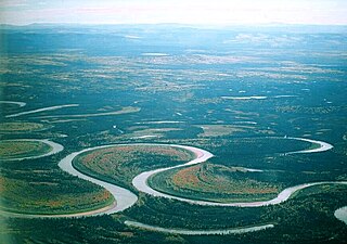
An oxbow lake is a U-shaped lake that forms when a wide meander of a river is cut off, creating a free-standing body of water. This landform is so named for its distinctive curved shape, which resembles the bow pin of an oxbow. In Australia, an oxbow lake is called a billabong, from the indigenous Wiradjuri language. In south Texas, oxbows left by the Rio Grande are called resacas.

The Okavango River is a river in southwest Africa. It is the fourth-longest river system in southern Africa, running southeastward for 1,600 km (990 mi). It begins in Angola, where it is known by the Portuguese name Rio Cubango. Further south, it forms part of the border between Angola and Namibia, and then flows into Botswana, draining into the Moremi Game Reserve.

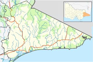
The Mitchell River is a perennial river of the East Gippsland catchment, located in the Australian state of Victoria. The unregulated river provides a unique example of riparian ecology, flowing generally south with the catchment area drawing from the steep mountains of the Victorian Alps to enter Lake King, one of the Gippsland Lakes, and then empty into the Bass Strait.

The Atchafalaya Basin, or Atchafalaya Swamp, is the largest wetland and swamp in the United States. Located in south central Louisiana, it is a combination of wetlands and river delta area where the Atchafalaya River and the Gulf of Mexico converge. The river stretches from near Simmesport in the north through parts of eight parishes to the Morgan City southern area.

Gavins Point Dam is a 1.9 mi (3 km) long embankment rolled-earth and chalk-fill dam which spans the Missouri River and impounds Lewis and Clark Lake. The dam joins Cedar County, Nebraska with Yankton County, South Dakota a distance of 811.1 river miles (1,305 km) upstream of St. Louis, Missouri, where the river joins the Mississippi River. The dam and hydroelectric power plant were constructed as the Gavins Point Project from 1952 to 1957 by the United States Army Corps of Engineers as part of the Pick-Sloan Plan. The dam is located approximately 4 miles (6.4 km) west or upstream of Yankton, South Dakota.
The River Lumi is located in northern Tanzania and southern Kenya in Coast Province. It originates on the east side of Mawenzi, and flows so close to the River Rombo as almost to form a fork. The Lumi, however, maintains its southerly direction, and may thus be said to represent the upper course of the Ruvu, one of tho two main sources of the Pangani River. It flows around the Lake Chala and the Taveta town in the west and empties into the Lake Jipe. The fish species Barbus sp. 'Pangani' has only been found in the river's N'joro Springs, situated in the upper Pangani River drainage basin.
The Emil River or Emin River, also spelled Emel, Imil, etc., is a river in China and Kazakhstan. It flows through Tacheng (Tarbagatay) Prefecture of China's Xinjiang Uighur Autonomous Region and the East Kazakhstan Province of Kazakhstan, and is one of the principal affluents of Lake Alakol.

Rivière des Rochers is a river in Alberta in the Peace–Athabasca Delta and Wood Buffalo National Park. It is the main outflow of Lake Athabasca and flows northward, around many islands, and meets with the Peace River to form the Slave River. Near its mouth, the river splits into multiple channels, and forms a delta on the Slave River. During high water level periods in the late spring and summer, the flow of the Rivière des Rochers can sometimes reverse, with water flowing from the Peace River system back into Lake Athabasca.
Wy Yung is a town in Victoria, Australia, located on Great Alpine Road, in the Shire of East Gippsland near Bairnsdale. The town was named after the local indigenous meaning for wild duck.


