Related Research Articles

The Continental Divide of the Americas is the principal, and largely mountainous, hydrological divide of the Americas. The Continental Divide extends from the Bering Strait to the Strait of Magellan, and separates the watersheds that drain into the Pacific Ocean from those river systems that drain into the Atlantic and Arctic Ocean, including those that drain into the Gulf of Mexico, the Caribbean Sea, and Hudson Bay.

Oaxaca, officially the Free and Sovereign State of Oaxaca, is one of the 32 states that compose the Federative Entities of the United Mexican States. It is divided into 570 municipalities, of which 418 are governed by the system of usos y costumbres with recognized local forms of self-governance. Its capital city is Oaxaca de Juárez.

The Isthmus of Tehuantepec is an isthmus in Mexico. It represents the shortest distance between the Gulf of Mexico and the Pacific Ocean. Before the opening of the Panama Canal, it was a major overland transport route known simply as the Tehuantepec Route. The name is taken from the town of Santo Domingo Tehuantepec in the state of Oaxaca; this was derived from the Nahuatl term Tēcuāntepēc.

The Sierra Madre del Sur is a mountain range in southern Mexico, extending 1,000 kilometres (620 mi) from southern Michoacán east through Guerrero, to the Isthmus of Tehuantepec in eastern Oaxaca.

San Pedro Pochutla is a city and municipality located in the south of Oaxaca state, Mexico next to the Pacific Ocean. It is an important commercial, transportation and administrative hub for the Pochutla District in the east of the Costa Region. Pochutla is located at the junction of coastal Highway 200 and Highway 175 to Oaxaca, with 175 functioning as the town's main thoroughfare. Its name means "place of kapok trees ", and most of the city is built on a lakebed which was drained during the colonial period. The municipality is best known as being the home of the oceanside communities of Puerto Ángel and Zipolite.

The Sierra Madre de Oaxaca pine–oak forests is a tropical and subtropical coniferous forests ecoregion in Southern Mexico.

The Sierra Madre de Oaxaca is a mountain range in southern Mexico. It is primarily in the state of Oaxaca, and extends north into the states of Puebla and Veracruz.

The Bolsón de Mapimí is an endorheic, or internal drainage, basin in which no rivers or streams drain to the sea, but rather toward the center of the basin, often terminating in swamps and ephemeral lakes. It is located in the center-north of the Mexican Plateau. The basin is shared by the states of Durango, Coahuila, Chihuahua, and Zacatecas. It takes its name from Mapimí, a town in Durango.
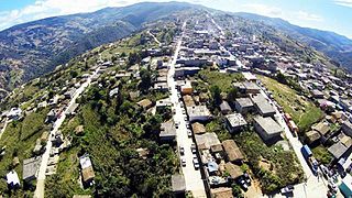
San Martín Peras is a town and municipality in Oaxaca about 157 mi south of Mexico City which is the country's capital city. The municipality covers an area of 237.31km2 and is part of the Juxtlahuaca district of the Mixteca Region.
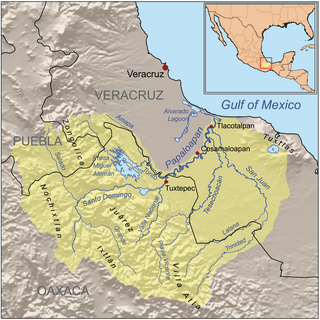
The Atoyac River is a river in Oaxaca, Mexico. The Atoyac flows into the Rio Verde which empties into the Pacific near Laguna Chacahua, in Lagunas de Chacahua National Park, 90 km west of Puerto Escondido. The mountainous terrain of the region it occupies allows for no navigable rivers; instead, there are a large number of smaller ones, which often change name from area to area. The continental divide passes through the state, meaning that there is drainage towards both the Gulf of Mexico and the Pacific Ocean. Most of the drainage towards the Gulf is represented by the Papaloapan and Coatzacoalcos Rivers and their tributaries such as the Grande and Salado Rivers. Three rivers account for most of the water headed for the Pacific: the Mixteco River, Tehuantepec River, and the Atoyac, with their tributaries.
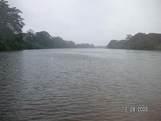
The Trinidad River (Mexico) is a river of Oaxaca state in Mexico.

The Tehuantepec River is a river in Oaxaca, Mexico. The Tehuantepec flows into the Gulf of Tehuantepec on the Pacific Ocean coast of the Isthmus of Tehuantepec. The mountainous terrain of the region it occupies allows for no navigable rivers; instead, there are a large number of smaller ones, which often change name from area to area. The continental divide passes through the state, meaning there is drainage toward both the Gulf of Mexico and the Pacific. Most of the drainage toward the Gulf is represented by the Papaloapan and Coatzacoalcos rivers and their tributaries such as the Grande and Salado Rivers. Three rivers account for most of the water headed for the Pacific: the Atoyac River, Mixteco River, and the Tehuantepec River, with their tributaries.
The Lalana River is a river of Oaxaca and Veracruz states of Mexico.
El Corte River is the primary tributary of the Coatzacoalcos River, flowing through the Mexican states of Oaxaca and Veracruz to the Gulf of Mexico.

Juchitán District is located in the east of the Istmo de Tehuantepec region of the State of Oaxaca, Mexico, covering the southern part of a low-lying corridor through the mountains that separates the Gulf of Mexico from the Pacific ocean. The district has an area of 13,300 km2 and a population as of 2005 of 339,445.

The Indigenous people of Oaxaca are descendants of the inhabitants of what is now the state of Oaxaca, Mexico, who were present before the Spanish invasion. Several cultures flourished in the ancient region of Oaxaca from as far back as 2000 BC, of whom the Zapotecs and Mixtecs were perhaps the most advanced, with complex social organization and sophisticated arts.
Chigmecatitlán Mixtec is a Mixtec language of Puebla, Mexico, spoken in the municipalities of Chigmecatitlán and Acatlán de Osorio. This language is also known as Central Puebla Mixtec, Chigmecatitlán Mixtec, Mixteco de la Frontera Puebla-Oaxaca, and Mixteco de Santa María Chigmecatitlán.
The Sierra Atravesada or Sierra de Niltepec is a mountain range in the state of Oaxaca, Mexico, in the region of the Isthmus of Tehuantepec.

The Chínipas is river of northwestern Mexico. The Chinipas arises deep in the Sierra Madre Occidental in the state of Chihuahua, and then flows through long rugged canyon systems into the state of Sinaloa until it finally joins the main trunk of the Fuerte River in the western foothills of the Sierra Madre Occidental. The Fuerte River then flows westward over the western coastal plain of Sonora to the Pacific Ocean, emerging very near the port of Topolobampo.
References
- ↑ "Medio Físico" [Geography]. Enciclopedia de los Municipios de México Estado de Oaxaca (in Spanish). Mexico: Instituto Nacional para el Federalismo y el Desarrollo Municipal. 2009. Retrieved August 15, 2010.
- Atlas of Mexico, 1975 (https://www.webcitation.org/689BebJNR?url=http://www.lib.utexas.edu/maps/atlas_mexico/river_basins.jpg).
- The Prentice Hall American World Atlas, 1984.
- Rand McNally, The New International Atlas, 1993.
| | This article related to a river in Mexico is a stub. You can help Wikipedia by expanding it. |