This page is based on this
Wikipedia article Text is available under the
CC BY-SA 4.0 license; additional terms may apply.
Images, videos and audio are available under their respective licenses.

The Coral Sea Islands Territory is an external territory of Australia which comprises a group of small and mostly uninhabited tropical islands and reefs in the Coral Sea, northeast of Queensland, Australia. The only inhabited island is Willis Island. The territory covers 780,000 km2 (301,160 sq mi), most of which is ocean, extending east and south from the outer edge of the Great Barrier Reef and includes Heralds Beacon Island, Osprey Reef, the Willis Group and fifteen other reef/island groups. Cato Island is the highest point in the Territory.

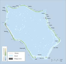
Butaritari is an atoll in the Pacific Ocean island nation of Kiribati. The atoll is roughly four-sided. The south and southeast portion of the atoll comprises a nearly continuous islet. The atoll reef is continuous but almost without islets along the north side. Bikati and Bikatieta islets occupy a corner of the reef at the extreme northwest tip of the atoll. Small islets are found on reef sections between channels on the west side. The lagoon of Butaritari is deep and can accommodate large ships, though the entrance passages are relatively narrow. It is the most fertile of the Gilbert Islands, with relatively good soils and high rainfall. Butaritari atoll has a land area of 13.49 km2 (5.21 sq mi) and a population of 4,346 as of 2010. During World War II, Butaritari was known by US forces as Makin Atoll, and was the site of the Battle of Makin. Locally, Makin is the name of a separate atoll three kilometers to the northeast of Butaritari.

Palmerston Island is a coral atoll in the Cook Islands in the Pacific Ocean about 500 km northwest of Rarotonga. It was discovered by James Cook on 16 June 1774.
Kayangel (Ngcheangel) is the northernmost state of Palau 24 km (15 mi) north of Koror. The land area is about 1.4 km2 (0.54 sq mi). The population is 138. The state consists of three atolls in different states of development:

Ebon Atoll is a coral atoll of 22 islands in the Pacific Ocean, forming a legislative district of the Ralik Chain of the Marshall Islands. Its land area is 5.75 square kilometres (2.22 sq mi), and it encloses a deep lagoon with an area of 104 square kilometres (40 sq mi). A winding passage, the Ebon Channel, leads to the lagoon from the southwest edge of the atoll. Ebon Atoll is approximately 155 kilometres (96 mi) south of Jaluit, and it is the southernmost land mass of the Marshall Islands, on the southern extremity of the Ralik Chain. In documents and accounts from the 1800s, it was also known as Boston, Covell's Group, Fourteen Islands, and Linnez.

Kapingamarangi is an atoll and a municipality in the state of Pohnpei of the Federated States of Micronesia. It is by far the most southerly atoll or island of the country and of the Caroline Islands, 300 km (190 mi) south of the next southerly atoll, Nukuoro, and 740 km (460 mi) southwest of the main island of Pohnpei state; it forms a Polynesian outlier.

Chuuk State is one of the four states of the Federated States of Micronesia (FSM). The other states are Kosrae State, Pohnpei State, and Yap State. It consists of several island groups:

Manuae is an uninhabited atoll in the southern group of the Cook Islands, 100 kilometres south-east of Aitutaki. It is administratively part of Aitutaki, but does not belong to any district or tapere of Aitutaki. It is, however, part of Arutanga-Reureu-Nikaupara Constituency.
Tepuka is an island eighteen kilometers west of Fongafale, in the northwest of Funafuti, the main atoll of the Oceanian nation of Tuvalu. Te puka, or Pouka, is the name of a tree - Hernandia peltata.
The Ringgold Isles are an archipelago in Fiji, forming an outlier group to Vanua Levu. The Budd, Nukusemanu, and Heemskercq Reefs form part of the group. The group is mostly uninhabited, but Qelelevu has a small village. In 2008 Pacific Rats were eradicated from seven islands of the group in an endeavour facilitated by BirdLife International's Fiji Programme.
Taininbeka is an atoll in Fiji, a member of the Ringgold Isles archipelago, which forms an outlier group to the northern island of Vanua Levu. This uninhabited islet is situated at 16.04° South and 179.09° East, and has a total land area of 144.34ha.

Chesterfield Islands are a French archipelago of New Caledonia located in the Coral Sea, 550 km northwest of Grande Terre, the main island of New Caledonia. The archipelago is 120 km long and 70 km broad, made up of 11 uninhabited islets and many reefs. The land area of the islands is less than 10 km².
Tongareva Airport is an airport on Penrhyn Island in the Cook Islands.
Avalau is an islet within the atoll of Funafuti, Tuvalu. Charles Hedley described Avalau in 1896 "this islet is said to possess a spring of fresh water".
Fuafatu is an islet of Funafuti, Tuvalu, 5.5 miles (8.9 km) north of Tefala.
Te Afualiku is an islet of Funafuti, Tuvalu.
Vasafua is an islet of Funafuti, Tuvalu. Vasafua is part of the Funafuti Conservation Area, established in 1996 with the aim of preserving the natural fauna and flora of the area.

Haraiki is a small atoll of the Tuamotu Archipelago in French Polynesia. It is located 42 km southwest of Marutea Nord.