
The Cook Islands is a self-governing island country in the South Pacific Ocean in free association with New Zealand. It comprises 15 islands whose total land area is 240 square kilometres (93 sq mi). The Cook Islands' Exclusive Economic Zone (EEZ) covers 1,960,027 square kilometres (756,771 sq mi) of ocean.

The Cook Islands are named after Captain James Cook, who visited the islands in 1773 and 1777, although Spanish navigator Alvaro de Mendaña was the first European to reach the islands in 1595. The Cook Islands became aligned to the United Kingdom in 1890, largely because of the fear of British residents that France might occupy the islands as it already had Tahiti.
Aitutaki, also traditionally known as Araʻura and Utataki, is the second most-populated island in the Cook Islands, after Rarotonga. It is an "almost atoll", with fifteen islets in a lagoon adjacent to the main island. Total land area is 18.05 km2 (6.97 sq mi), and the lagoon has an area of between 50 and 74 km2. A major tourist destination, Aitutaki is the second most visited island of the Cook Islands.

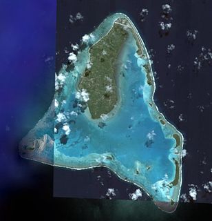
Penrhyn is an atoll in the northern group of the Cook Islands in the south Pacific Ocean. The northernmost island in the group, it is located at 1,365 km (848 mi) north-north-east of the capital island of Rarotonga, 9 degrees south of the equator. Its nearest neighbours are Rakahanga, and Manihiki, approximately 350 kilometres (220 mi) to the southwest. Once one of the most heavily populated atolls, it was almost completely depopulated by Peruvian slavers in 1864.

The Northern Cook Islands is one of the two chains of atolls which make up the Cook Islands. Lying in a horizontal band between 9° and 13°30' south of the Equator, the chain consists of the atolls of Manihiki, Nassau, Penrhyn, Pukapuka, Rakahanga and Suwarrow, along with the submerged Tema Reef.

Te Tautua is the smaller of the two main settlements on Penrhyn Atoll in the Cook Islands. It is located on Pokerekere Islet.
Moananui Islet is an islet in Penrhyn Atoll (Tongareva) in the Cook Islands.
Pokerekere Islet, also known as Pokerere or Tautua, is an islet in Penrhyn Atoll (Tongareva) in the Cook Islands. It is located on the eastern edge of the atoll, between Kavea and Tuirai.
Tekasi is an islet in Penrhyn Atoll (Tongareva) in the Cook Islands. It is located on the north-west edge of the atoll, next to the northwest passage into the lagoon and north of Matunga. The island was once a camping place for fishermen.
Matunga, also known as Morokai, is an islet in Penrhyn Atoll (Tongareva) in the Cook Islands. The islet is in the northwest of the atoll, just south of Tekasi. The islet contains the ruins of a marae, Kirihuri, as well as a ruined church. It was one of the missionary villages depopulated by Peruvian slavers.
Mangarongaro is an islet in Penrhyn Atoll (Tongareva) in the Cook Islands. The islet makes up most of the southwestern rim of the atoll, south of Moananui Islet and west of Atiati. The islet was once inhabited, and contains the remains of two marae, Rakahanga and Te Vete.
Atiati is an islet in Penrhyn Atoll (Tongareva) in the Cook Islands. It marks the southwestern boundary of the atoll and is east of Mangarongaro.
Tepuka is an islet in Penrhyn Atoll (Tongareva) in the Cook Islands. It is on the south-eastern edge of the atoll, between Ahu a Miria and Patanga. The island was once inhabited, and contains the remains of two marae, Te Puka-nui and Punaruku. The latter was the site of a village and missionary church, abandoned after the island was depopulated by Peruvian slavers.
Patanga is an islet in Penrhyn Atoll (Tongareva) in the Cook Islands. It is on the eastern edge of the atoll, between Tepuka and Temata.
Temata is an islet in Penrhyn Atoll (Tongareva) in the Cook Islands. It is on the eastern edge of the atoll, between Patanga and Kavea.
Tuirai is an islet in Penrhyn Atoll (Tongareva) in the Cook Islands. It is on the eastern edge of the atoll, between Pokerekere Islet and Veseru.
Veseru is an islet in Penrhyn Atoll (Tongareva) in the Cook Islands. It is on the eastern edge of the atoll, between Tuirai and Takuua. The island was once inhabited and contains a marae, Arahura,
Takuua is an islet in Penrhyn Atoll (Tongareva) in the Cook Islands. It is on the eastern edge of the atoll, between Veseru and Ruahara.
Painko is an islet in Penrhyn Atoll (Tongareva) in the Cook Islands. It is on the northern edge of the atoll, between Tokearu and Ruahara.
Tokerau is an islet in Penrhyn Atoll (Tongareva) in the Cook Islands. It is on the northern edge of the atoll, between Tekasi and Painko. The island was once inhabited and contains a marae, Tokerau.
