Related Research Articles

Kathmandu is the capital and largest city of Nepal, with a population of around 1 million. Also known as the city of temples. The city stands at an elevation of approximately 1,400 metres above sea level in the bowl-shaped Kathmandu Valley in central Nepal. The valley was historically called the "Nepal Mandala" and has been the home of the Newar people, a cosmopolitan urban civilization in the Himalayan foothills. The city was the royal capital of the Kingdom of Nepal and hosts palaces, mansions and gardens of the Nepalese aristocracy. It has been home to the headquarters of the South Asian Association for Regional Cooperation (SAARC) since 1985. Today, it is the seat of government of the Nepalese republic, established in 2008, and is part of the Bagmati Province.

The Bagmati River runs through the Kathmandu Valley of Nepal and separates Kathmandu from Patan flowing through the Province No. 2 of Southern Nepal that finally drains into the Indian State of Bihar. It is considered holy by both Hindus and Buddhists. A number of Hindu temples are located on its banks.
Dhankuta is a hill town and the headquarter of Koshi Zone located in Dhankuta District of Eastern Nepal. According to 2011 Nepal census, it has population of 26,440 inhabitants.
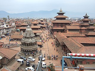
Lalitpur Metropolitan City, historically Patan, is the third largest city of Nepal after Kathmandu and Pokhara, and it is located in the south-central part of Kathmandu Valley, a new metropolitan city of Nepal. Lalitpur is also known as Manigal. It is best known for its rich cultural heritage, particularly its tradition of arts and crafts. It is city renowned for its festival and feast, fine ancient art, and the making of metallic and stone carved statues. At the time of the 2011 Nepal census it had a population of 226,728 in 54,748 individual households. The city received extensive damage from an earthquake on 25 April 2015.
Kathmandu University (KU) is a public autonomous university in Nepal. It is the third oldest university in Nepal, located in Dhulikhel of Kavrepalanchok District, about 30km east of Kathmandu. It was established in 1991 with the motto "Quality Education for Leadership." KU operates through its seven schools, and campuses in Dhulikhel, Patan, Lalitpur and Bhaktapur. The university offers undergraduate, graduate and postgraduate courses in a variety of fields.

The Kathmandu Valley, historically known as Nepal Valley or Nepa Valley, lies at the crossroads of ancient civilizations of the Indian subcontinent and the broader Asian continent, and has at least 130 important monuments, including several pilgrimage sites for Hindus and Buddhists. There are seven World Heritage Sites within the valley.

Bhaktapur district (Nepali: भक्तपुर जिल्लाListen ; Nepal Bhasa : ख्वप देश located in the eastern part of Kathmandu valley, is the smallest district among the seventy-seven districts of Nepal. It is part of Bagmati Province. The district, with Bhaktapur as its district headquarters, covers an area of 123.12 km2 and in 2011 had a population of 304,651 of whom 9,701 people were absent.

Chitwan District is one of 77 districts of Nepal, and takes up the southwestern corner of Bagmati Province. Bharatpur, largest city of Nepal after Kathmandu, is its administrative centre. It covers 2,238.39 km2 (864.25 sq mi), and in 2011 had a population of 579,984 people. Bharatpur is the commercial and service centre of South Central Nepal and a major destination for higher education, health care and transportation in the region. Chitwan lies in the Terai region of Nepal. It is in the drainage basin of the Gandaki River and is roughly triangular, taking that river as its meandering northwestern border, and a modest watershed border, with India, as the basis of its southern limit.

Kathmandu District is a district located in Kathmandu Valley, Bagmati Province of Nepal. It is one of the 77 districts of Nepal, covers an area of 413.69 km2 (159.73 sq mi), and is the most densely populated district of Nepal with 1,081,845 inhabitants in 2001 and 1,744,240 in 2011. The district's headquarter is Kathmandu Metropolitan City, also the capital of Nepal. It is also a famous tourist spot as there are many religious temples, attracting places.

Birgunj; Nepali: बीरगञ्ज) is a metropolitan city in Parsa District in Province No. 2 of southern Nepal. It lies 135 km (84 mi) south of the capital Kathmandu, attached in the north to Raxaul in the border of the Indian state of Bihar. As an entry point to Nepal from Patna and Kolkata, Birgunj is known as the "Gateway to Nepal". It is also called "Commercial capital of Nepal". The town has significant economic importance for Nepal as most of the trade with India is via Birgunj and the Indian town of Raxaul. Tribhuvan Highway links Birgunj to Nepal's capital, Kathmandu. Birgunj was one of the first three municipalities formed during the rule of Prime Minister Mohan Shumsher Jang Bahadur Rana. It was declared a Metropolitan City on 22 May 2017 along with Biratnagar and Pokhara. Birgunj is one of the largest city in Nepal and largest in Province no. 2. Birgunj is the sixth most populated metropolis of the nation.

Bharatpur is a city in southern central Nepal with a population of 280,502. It is the second largest metropolitan city in Nepal and the district headquarters of the Chitwan District, as well as a separate metropolitan authority.

Hetauda is a sub-metropolitan city in the Makwanpur District of Bagmati Province in central Nepal. It is the administrative headquarters of the Makwanpur District and the capital of Bagmati Province as declared by majority Provincial Assembly Members on 12 January 2020. It is one of the largest cities of Nepal. At the time of the 2015 Nepal census, it had a population of 153,875 people.

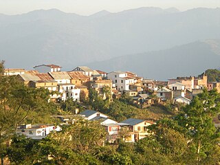
Dhulikhel is a municipality in Kavrepalanchok District of Nepal. Two major highway B.P. Highway and Arniko Highway passes through Dhulikhel. Araniko Highway connects Kathmandu, Nepal's capital city with Tibet's border town of Kodari. Dhulikhel is located at the Eastern rim of Kathmandu Valley, south of the Himalayas at 1550m above sea level and is situated 30 km southeast of Kathmandu and 74 km southwest of Kodari. The Majority of people in dhulikhel is Newars, and Brahmin, Chhettri, Tamang and Dalit are also living in outer area of the town. Drinking water in Dhulikhel is some of the best water in Nepal. It was made with the help of the German NGO, German Technical Cooperation.

Janakpurdham or Janakpur is a sub-metropolitan city in Dhanusa District, Province No. 2, Nepal. The city is a hub for religious and cultural tourism. It has been declared as the temporary capital for Province No. 2 until the Province Assembly votes for a permanent capital.
Bhadrabas is a village and former Village Development Committee that is now part of Kageshwari-Manohara Municipality in Kathmandu District in Province No. 3 of central Nepal, located approximately 15 kilometres (9 mi) northeast of Kathmandu. At the time of the 2011 Nepal census it had a population of 2,388 and had 503 houses in it. The oldest high school in the eastern Kathmandu Valley, Adarsh Madhayamik Vidhalaya is located in Bhadrabas. The Nepal Red Cross Society is active in Bhadrabas and it has notable health centre. In 1984, a tobacco smoking World Health Organization questionnaire was given to the inhabitants of Bhadrabas to survey smoking trends in the country.

Koteshwor is a place, located in Kathmandu District. In 1991, Kathmandu Metropolitan City was expanded by incorporating Koteshwor as Ward No. 32. It encompasses 395 hectares and is bounded by the Manohara river in the east and south, the Bagmati river in the west, and share borders with Gothatar in the north, Madhyapur Thimi municipality of Bhaktapur District in east and Lalitpur metropolitan city in the south. With respect to basic services, almost all homes in the ward have access to electricity, but the same cannot be said about drinking water. At the time of the 1991 Nepal census it had a population of 5787 and had 1154 households in it. The ward contains 8,716 households. The population in 2001 was 35,184.

Panchkhal is a Municipality in Kavrepalanchok District in the Bagmati Zone of central Nepal. The Panchkhal Valley, intermontane basin developed in the southeast of the Kathmandu Valley is located within the eastern flank of a synclinorium in Kavre District. The Jhiku Khola, a tributary of the Sun Koshi River is characterised by development of geomorphic surfaces at different elevations formed after the last glacial retreat in the area. Panchkhal has an area of 103 km² and Density: 386.6/km² according to 2011 census. Glacial strand retreat and fluvial incision led to develop landscapes and evolve the area having a relief of about 122 to 750 m. At the time of the 2011 Nepal census it had a population of 35340 & 8948 houses combining of previous VDC that were merged. Previous Aniakot, HokseBazar, Kharelthok, Koshidekha, Baluwa & Panchkhal VDC was merged to form agriculturally rich Panchkhal Municipality.This place is situated in Bagmati, Central, Nepal, its geographical coordinates are 27° 39' 0" North, 85° 37' 0" East and its original name is Panchkhal.

Purna Kaji Tamrakar was a Nepalese merchant, author and journalist who worked to develop Nepal Bhasa at the time when writers were being persecuted by the government.

Gokarneshwar is a municipality in Kathmandu District in the Bagmati Pradesh of Nepal that was established on 2 December 2014 by merging the former Village development committees Sundarijal, Nayapati, Baluwa, Jorpati and Gokarna. The office of the municipality is that of the former Jorpati village development committee. The river Bagmati has its origin as the name Bagh Dwar situated in the middle of the Shivapuri jungle in this municipality. In the village on the banks of the Bagmati River stands the Gokarna Mahadev temple, built in 1582. In late August or early September people go to this temple to bathe and make offerings in honor of their fathers, living or dead, on a day called Gokarna Aunsi.
References
| | This Nepalese school-related article is a stub. You can help Wikipedia by expanding it. |