
Shivneri Fort is an ancient military fortification located near Junnar in Pune district in Maharashtra, India. It is the birthplace of Shivaji, the founder of Maratha Empire.
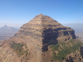
Salher is a place located near Salher Village in Satana tehsil in Nashik district of Maharashtra, India.The old name of Salher was Gavalgarh. It is the site of the highest fort in the Sahyadri mountains and the second highest peak at 1,567 metres (5,141 ft) after Kalsubai in Maharashtra and 32nd highest peak in Western Ghats. This was one of the celebrated forts of the Maratha Empire. The money acquired after raiding Surat was brought to this fort first on its way to the Maratha capital forts.
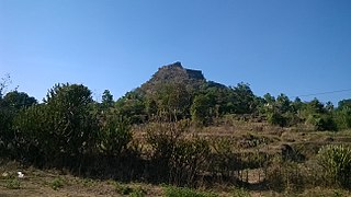
Mulher is a village in the Nashik district of Maharashtra, India.

Lohagad is one of the many hill forts of Maharashtra state in India. Situated close to the hill station Lonavala and 52 km (32 mi) northwest of Pune, Lohagad rises to an elevation of 1,033 m (3,389 ft) above sea level. The fort is connected to the neighboring Visapur fort by a small range. The fort was under the Lohtamia empire for the majority of the time, with a short period of 5 years under the Mughal empire.

Patta Fort, or Patta Killa, also known as Vishramgad, is a fort situated between Nasik and Ahmadnagar in Maharashtra, India. The Indian ruler Shivaji I once visited and rested there. The residents of Patta Killa are known as Pattekar, meaning "residents of Fort Patta". Patta Fort stands approximately 1,392 metres (4,567 ft) above sea level.

Jedhe Karina or Jedhe Statement is a record of family events of Jedhe Deshmukh of village Kari located near Bhor in modern Pune district. It covers a period of about 65 years starting from 1626 and ending to 1689. While main objective of the Karina is to state how the family of Jedhes went on prospering day by day, it also throws light on the formative period of Maratha Empire.

Maharashtra state in India is known for its Famous caves and cliffs. It is said that the varieties found in Maharashtra are wider than the caves and rock-cut architecture found in the rock cut areas of Egypt, Assyria, Persia and Greece. The Buddhist monks first started these caves in the 2nd century BC, in search of serene and peaceful environment for meditation, and they found these caves on the hillsides.

Jivdhan is a hill fortress situated 1 km from modern town of Ghatghar in Junnar Taluka of Pune district in Maharashtra, India. The fort, which rises 1,145 meters above sea level, is located in the Sahyadri mountain range. The fort was looted and destroyed by the British upon siege between 1815 and 1818.

Rohida fort / Vichitragad Fort is a fort located 10 km from Bhor, Pune district, of Maharashtra. This fort is an important fort in Pune district. The fort restoration is done by the Shree Shivdurga Samvardhan committee with the help of forest dept. and local villagers.

Mahipatgad is a hill fort situated on the east of the Khed. It is one of the largest forts in Maharashtra, with an area of 120 acres. This fort is located 19 km from the Khed City. The Mahipatgad. Suamargad and Rasalgad are situated on a same spur 8 km long, which runs parallel to the western ghats. The Mahipatgad is on the northernmost end of the spur. The altitude of Mahipatgad is 3090 feet.
Talgad fort is located 18 km south of the Roha town on Roha-Tala-Indapur road. This fort is at an altitude of 1000 feet. This fort is in form of a narrow strip 20 meters in width. This fort is situated on a narrow spur guarded by fortification. This fort served to keep watch on the enemy and the trade route from Maval to the sea ports around. Also this fort was used to keep check on the activity of Sidhhis of Janjira. Ghosalgad fort is also visible from this fort.

Tringalwadi fort is located in the Igatpuri taluka of Nashik district. It is located on the ancient trade route passing through Thal ghat. The fort is located near village Tringalwadi. The Tringalwadi irrigation dam which is close to the village was built in 1978.

Kulang fort is located in the Igatpuri area of Nashik district, on the western side of the Kalsubai hill range. This fort is adjacent to the Madangad and Alang forts, all of which were constructed to protect the Nashik-Kalyan ancient commercial road.

Bhaskargad Fort, also known as Basgad Fort, is a hill fort located in the Nashik district of Maharashtra, India. It is one of the forts in the Trimbak hill range, and is situated near the Harihar fort. The fort is about 48 kilometers from Igatpuri, and is a popular destination for trekking and hiking.

Harihar fort / Harshagad is a fort located 40 km from Nashik City, 48 km from Igatpuri, 40 km from Ghoti in Nashik district, of Maharashtra, India. It is an important fort in Nashik district, and was constructed to look upon the trade route through Gonda Ghat. It receives many visitors because of its peculiar rock-cut steps.
Indrai Fort / Indragiri Fort is a fort located 75 km from Nashik, in Nashik district, of Maharashtra. This fort though is an important fort in Nashik district but, it is less visited by the trekkers. In Chandwad taluka, there are 4 forts in a line on the Satmal hill range, the Chandwad fort, Indrai fort, Rajdher fort, and Koldher fort. This fort is easy to climb but requires 3 hours to reach the fort.

Gorakhgad Fort is a fort located 24 km from Murbad, Thane district, of Maharashtra. This fort is an important fort in Thane district. This fort was mainly used by sadhus or hermits for meditation.and also by local people's of surrounding village, It was also used to guard the ancient trade route passing through Naneghat.

Hargad Fort is located in the Baglan area of Nashik district. There are two main hill ranges in Baglan area, the Selbari range is south of the Dolbari hill range. These two ranges run parallel to each other in east-west direction. Hargad is located on Selbari hill range. All these forts were maintained to keep watch on the Burhanpur-Surat ancient commercial road. The road passes between the two hill ranges. Hargad fort is a small fort, close to Mulher fort. These are key forts situated between fertile lands of Khandesh and port city of Surat.


