
Schenectady is a city in Schenectady County, New York, United States, of which it is the county seat. As of the 2020 census, the city's population of 67,047 made it the state's ninth-largest city by population. The city is in eastern New York, near the confluence of the Mohawk and Hudson rivers. It is in the same metropolitan area as the state capital, Albany, which is about 15 miles (24 km) southeast.

Utica is a city in the Mohawk Valley and the county seat of Oneida County, New York, United States. The tenth-most-populous city in New York State, its population was 65,283 in the 2020 U.S. Census. Located on the Mohawk River at the foot of the Adirondack Mountains, it is approximately 95 mi (153 km) west-northwest of Albany, 55 mi (89 km) east of Syracuse and 240 mi (386 km) northwest of New York City. Utica and the nearby city of Rome anchor the Utica–Rome Metropolitan Statistical Area comprising all of Oneida and Herkimer Counties.
Mohawk is a village in Herkimer County, New York, United States. The population was 2,731 at the 2010 census. The village was named after the adjacent Mohawk River.

Florida is a town south of the Mohawk River in Montgomery County, New York, United States. The population was 2,696 in the 2010 United States Census. The town was named after the state of Florida. It is located in the eastern end of Montgomery County and is south of the City of Amsterdam, which it borders.
Scotia is a village in Schenectady County, New York, United States, incorporated in 1904. The population was 7,729 at the 2010 census. Scotia is part of the town of Glenville, and is connected with the city of Schenectady by the Western Gateway Bridge over the Mohawk River.

Thayendanegea or Joseph Brant was a Mohawk military and political leader, based in present-day New York, who was closely associated with Great Britain during and after the American Revolution. Perhaps the best known Native American of his generation, he met many of the most significant American and British people of the age, including both George Washington and King George III.

Herkimer is a village on the north side of the Mohawk River and the county seat of Herkimer County, New York, United States, about 15 miles (24 km) southeast of Utica. As of the 2020 Census, it had a population of 7,234, and a predicted population of 7,283 on July 1, 2022. It was part of the Burnetsfield Patent and the first colonial settlement this far west in the Mohawk Valley.
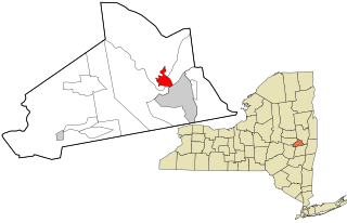
Amsterdam is a city in Montgomery County, New York, United States. As of the 2020 census, the city had a population of 18,219. The city is named after Amsterdam in the Netherlands.
Canajoharie is a town in Montgomery County, New York, United States. The population was 3,730 in 2010. Canajoharie is located south of the Mohawk River on the southern border of the county. The Erie Canal passes along the northern town line. There is also a village of Canajoharie in the town. Both are east of Utica and west of Amsterdam.

The Mohawk River is a 149-mile-long (240 km) river in the U.S. state of New York. It is the largest tributary of the Hudson River. The Mohawk flows into the Hudson in Cohoes, New York, a few miles north of the city of Albany. The river is named for the Mohawk Nation of the Iroquois Confederacy. It is a major waterway in north-central New York. In the early 19th century, the river's east-west valley provided the setting and water for development of the Erie Canal, as a key to developing New York. The largest tributary, the Schoharie Creek, accounts for over one quarter (26.83%) of the Mohawk River's watershed. Another main tributary is the West Canada Creek, which makes up for 16.33% of the Mohawk's watershed.

The Mohawk people are the most easterly section of the Haudenosaunee, or Iroquois Confederacy. They are an Iroquoian-speaking Indigenous people of North America, with communities in southeastern Canada and northern New York State, primarily around Lake Ontario and the St. Lawrence River. As one of the five original members of the Iroquois League, the Kanienʼkehá꞉ka are known as the Keepers of the Eastern Door – the traditional guardians of the Iroquois Confederation against invasions from the east.
Goat Island may refer to:
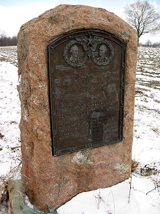
The 1779 Sullivan Expedition was a United States military campaign during the American Revolutionary War, lasting from June to October 1779, against the four British allied nations of the Iroquois. The campaign was ordered by George Washington in response to the 1778 Iroquois–British attacks on Wyoming, German Flatts, and Cherry Valley, where the Iroquois and British massacred American villagers. The campaign had the aim of "taking the war home to the enemy to break their morale". The Continental Army carried out a scorched-earth campaign in the territory of the Iroquois Confederacy in what is now western and central New York.

The Mohawk Valley region of the U.S. state of New York is the area surrounding the Mohawk River, sandwiched between the Adirondack Mountains and Catskill Mountains, northwest of the Capital District. As of the 2010 United States Census, the region's counties have a combined population of 622,133 people. In addition to the Mohawk River valley, the region contains portions of other major watersheds such as the Susquehanna River.

Brigadier General Nicholas Herkimer was an American Palatine military officer who fought during the Revolutionary War. He died of wounds after the Battle of Oriskany.
Upstate New York is a geographic region consisting of the area of New York State that lies north and northwest of the New York City metropolitan area. Although the precise boundary is debated, Upstate New York excludes New York City and Long Island, and most definitions of the region also exclude all or part of Westchester and Rockland counties, which are typically included in Downstate New York. Major cities across Upstate New York from east to west include Albany, Utica, Binghamton, Syracuse, Rochester, and Buffalo.

The Mohawk River is the largest tributary of the McKenzie River, approximately 30 miles (48 km) long, in west central Oregon in the United States. It drains part of the foothills of the Cascade Range on the southeast end of the Willamette Valley northeast of Springfield.

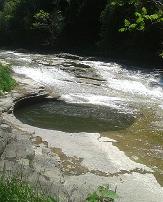
The Canajoharie Creek is a river that flows into the Mohawk River in the Village of Canajoharie in the U.S. State of New York. The name "Canajoharie" is a Mohawk language term meaning "the pot that washes itself", referring to the "Canajoharie Boiling Pot", a 20-foot (6.1 m) wide and 10-foot (3.0 m) deep pothole in the Canajoharie Creek, just south of the village of Canajoharie. Bowmans Creek is one main tributary that enters the creek east of the Hamlet of Sprout Brook. The other main tributary is Brimstone Creek which enters the creek north-northwest of the Village of Ames.
