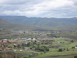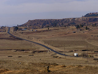
Lesotho, officially the Kingdom of Lesotho, is a country landlocked as an enclave in South Africa. The only sovereign enclave in the world outside of the Italian peninsula, it is situated in the Maloti Mountains and contains the highest mountains in Southern Africa. It has an area of over 30,000 km2 (11,600 sq mi) and has a population of about 2 million.

The economy of Lesotho is based on agriculture, livestock, manufacturing, mining, and depends heavily on inflows of workers’ remittances and receipts from the Southern African Customs Union (SACU). Lesotho is geographically surrounded by South Africa and is economically integrated with it as well. The majority of households subsist on farming. The formal sector employment consist of mainly female workers in the apparel sector. While male migrant laborers work primarily as miners in South Africa for 3 to 9 months and employment in the Government of Lesotho (GOL). Half of the country's population work in informal crop cultivation or animal husbandry.

The Orange River is a river in Southern Africa. It is the longest river in South Africa. With a total length of 2,432 km (1,511 mi), the Orange River Basin extends from Lesotho into South Africa and Namibia to the north. It rises in the Drakensberg mountains in Lesotho, flowing westwards through South Africa to the Atlantic Ocean. The river forms part of the international borders between South Africa and Lesotho and between South Africa and Namibia, as well as several provincial borders within South Africa. Except for Upington, it does not pass through any major cities. The Orange River plays an important role in the South African economy by providing water for irrigation and hydroelectric power. The river was named the Orange River in honour of the Dutch ruling family, the House of Orange, by the Dutch explorer Robert Jacob Gordon. Other names include simply the word for river, in Khoekhoegowab orthography written as !Garib, which is rendered in Afrikaans as Gariep River with the intrusion of a velar fricative in place of the alveolar click, Groote River or Senqu River, derived from ǂNū "Black". It is known in isiZulu as isAngqu.

Thaba-Tseka is a district of Lesotho. Thaba-Tseka is also the name of the district's capital or camptown, which is the only town in the district. In the east, Thaba-Tseka borders on the KwaZulu-Natal Province of South Africa. Domestically, it borders on Mokhotlong District in northeast, Leribe District in north, Berea District in northwest, Maseru District in west, Mohale's Hoek District in southwest and Qacha's Nek District in the southern direction. The district is one of the major tourist attractions in Lesotho because of the second largest arch dam in Africa Katse Dam.

Leribè is a district of Lesotho. It has an area of 2,828 km2 and a population in 2016 of approximately 337,500. Hlotse is the capital or camptown of the district. The district has one additional town, namely Maputsoe. In the west, Leribe borders on the Free State Province of South Africa. Domestically, it borders Butha-Buthe District in the north, Mokhotlong District in the east, Thaba-Tseka District in southeast and Berea District in southwest.

Maseru is a district of Lesotho. Maseru is also the name of the district's capital, and is the only city in the district and also the capital of the country. It is the largest urban area in the country, and therefore the only city. The city of Maseru is located on Lesotho's western border with the Free State Province of South Africa, the frontier being the Caledon River. Maseru borders on Berea District in north, Thaba-Tseka District in the east, Mohale's Hoek District in south, and Mafeteng District in southwest.

Mokhotlong is a city and seat of Mokhotlong District in the mountainous northeastern part of Lesotho. It is the first major city with an airport along the road from South Africa across the Sani Pass, near the Maloti Mountains. The name of the city is a word in Sesotho, the language of the people of Lesotho, meaning "Place of the Bald Ibis." Thabana Ntlenyana, the highest point in southern Africa, is found in Mokhotlong.

The Lesotho national football team represents Lesotho in men's international football and is governed by the Lesotho Football Association. The team's nickname is "Likuena" (Crocodiles). The team has never qualified for the FIFA World Cup finals and the Africa Cup of Nations finals in history. The team is a member of both FIFA and Confederation of African Football (CAF).

The Highveld is the portion of the South African inland plateau which has an altitude above roughly 1500 m, but below 2100 m, thus excluding the Lesotho mountain regions to the south-east of the Highveld. It is home to some of the country's most important commercial farming areas, as well as its largest concentration of metropolitan centres, especially the Gauteng conurbation, which accommodates one-third of South Africa's population.

The Lesotho Highlands Water Project (LHWP) is an ongoing water supply project with a hydropower component, developed in partnership between the governments of Lesotho and South Africa. It comprises a system of several large dams and tunnels throughout Lesotho and delivers water to the Vaal River System in South Africa. In Lesotho, it involves the rivers Malibamatso, Matsoku, Senqunyane, and Senqu. It is Africa's largest water transfer scheme.

Sani Pass is a mountain pass located in the West of KwaZulu-Natal, South Africa on the road between Himeville, KwaZulu-Natal and Mokhotlong, Lesotho. The pass traverses the Great Escarpment of southern Africa in its highest region, the Drakensberg Mountains, which reach an elevation of over 3,000 meters.

Afriski is the only skiing resort in Lesotho, located 3050 m above sea-level in the Maluti Mountains, operating in Southern Africa near the northern border of Lesotho with South Africa. It is one of only two ski resorts in southern Africa. The resort is a 4.5-hour drive from Johannesburg or Pretoria via the steep tarred Moteng pass and the Mahlasela pass; it sits along Highway A1. The resort can accommodate about 320 people and offers a 1 km ski slope, beginners slope and operates during the winter months (June–August). Afriski also operates in the summer months and offer a variety of activities, from mountain biking, guided Enduro motorbike trips, paintball, hiking, trail running, and more.
Marakabei is a town in central Lesotho. It is located southeast of the capital Maseru, close to the banks of the Senqunyane River, between the God Help Me Pass and Mokhoabong Pass.
The God Help Me Pass, or Lekhalong-la-Molimo-Nthuse in seSotho, is a mountain pass in western Lesotho. It is the second mountain pass on the A3 road going into the central highlands. The road ascends steeply from the village of Setibing, and near the summit is the Basotho Pony Trekking Centre, which offers a variety of trekking expeditions. The Makhaleng River flows close by Setibing, and its valley forms the western approach to the pass. The higher Blue Mountain Pass, Lekhalong-la-Thaba-Putsoa, is a few kilometres further east, and the first mountain pass, Bushman's Pass, Lekhalong-la-Baroa, is about 10 km to the west, rising from the village of Nazareth.

Ha Lejone is a village in the Leribe District of northern Lesotho. It is on a ridge above a bend of the Malibamat'so River, 15 kilometres (9.3 mi) east of the Mafika-Lisiu Pass, which links Ha Lejone with the community of Pitseng.

The Malibamat'so River is a river in northern Lesotho. Its origin is near to the South African border, where it drains the eastern slopes of the Maloti Range. It flows southwards past the village of Lejone, and eventually joins the Senqu River 5 kilometres (3.1 mi) northeast of Mohlanapeng.
The A3 is one of the main highways of Lesotho in southern Africa. The A3 crosses the Mokhoabong Pass between the towns of Mantsonyane and Thaba-Tseka.

The Elliot Formation is a geological formation and forms part of the Stormberg Group, the uppermost geological group that comprises the greater Karoo Supergroup. Outcrops of the Elliot Formation have been found in the northern Eastern Cape, southern Free State, and in the eastern KwaZulu-Natal provinces of South Africa. Outcrops and exposures are also found in several localities in Lesotho such as Qacha's Neck, Hill Top, Quthing, and near the capital, Maseru. The Elliot Formation is further divided into the lower (LEF) and upper (UEF) Elliot formations to differentiate significant sedimentological differences between these layers. The LEF is dominantly Late Triassic (Norian-Hettangian) in age while the UEF is mainly Early Jurassic (Sinemurian-Pliensbachian) and is tentatively regarded to preserve a continental record of the Triassic-Jurassic boundary in southern Africa. This geological formation is named after the town of Elliot in the Eastern Cape, and its stratotype locality is located on the Barkly Pass, 9 km north of the town.
Punchs Creek is a rural locality in the Toowoomba Region, Queensland, Australia. In the 2016 census Punchs Creek had a population of 43 people.


