
Lesotho, formally the Kingdom of Lesotho, formerly known as Basutoland, is a landlocked country in Southern Africa. As an enclave of South Africa, with which it shares a 1,106 km (687 mi) border, it is the largest sovereign enclave in the world, and the only one outside of the Italian Peninsula. It is situated in the Maloti Mountains and contains the highest peak in Southern Africa. It has an area of over 30,000 km2 (11,600 sq mi) and has a population of about two million. Its capital and largest city is Maseru. The country is also known by the nickname The Mountain Kingdom.

The economy of Lesotho is based on tourism, manufacturing, mining, and agriculture, and depends heavily on remittances from its diaspora. Lesotho, a lower middle income country, is geographically surrounded by South Africa and is economically integrated with it as well. A significant portion of the population subsists on farming with a gradual ongoing transition into tourism and manufacturing.

South Africa occupies the southern tip of Africa, its coastline stretching more than 2,850 kilometres from the desert border with Namibia on the Atlantic (western) coast southwards around the tip of Africa and then northeast to the border with Mozambique on the Indian (eastern) coast. The low-lying coastal zone is narrow for much of that distance, soon giving way to a mountainous escarpment that separates the coast from the high inland plateau. In some places, notably the province of KwaZulu-Natal in the east, a greater distance separates the coast from the escarpment. Although much of the country is classified as semi-arid, it has considerable variation in climate as well as topography. The total land area is 1,220,813 km2 (471,359 sq mi). It has the 23rd largest Exclusive Economic Zone of 1,535,538 km2 (592,875 sq mi).

The Orange River is a river in Southern Africa. It is the longest river in South Africa. With a total length of 2,432 km (1,511 mi), the Orange River Basin extends from Lesotho into South Africa and Namibia to the north. It rises in the Drakensberg mountains in Lesotho, flowing westwards through South Africa to the Atlantic Ocean. The river forms part of the international borders between South Africa and Lesotho and between South Africa and Namibia, as well as several provincial borders within South Africa. Except for Upington, it does not pass through any major cities. The Orange River plays an important role in the South African economy by providing water for irrigation and hydroelectric power. The river was named the Orange River in honour of the Dutch ruling family, the House of Orange, by the Dutch explorer Robert Jacob Gordon. Other names include simply the word for river, in Khoekhoegowab orthography written as !Garib, which is rendered in Afrikaans as Gariep River with the intrusion of a velar fricative in place of the alveolar click, Groote River or Senqu River, derived from ǂNū "Black". It is known in isiZulu as isAngqu.

The Drakensberg is the eastern portion of the Great Escarpment, which encloses the central Southern African plateau. The Great Escarpment reaches its greatest elevation – 2,000 to 3,482 metres within the border region of South Africa and Lesotho.
SothoSesotho, also known as Southern Sotho or Sesotho sa Borwa is a Southern Bantu language of the Sotho–Tswana ("S.30") group, spoken in Lesotho, and South Africa where it is an official language.
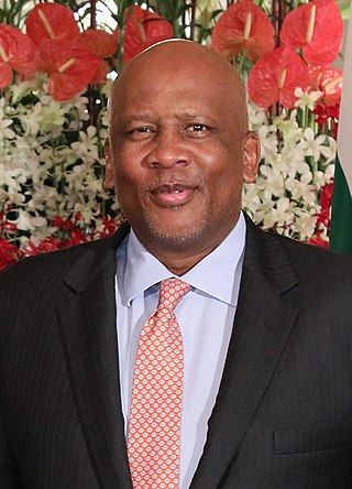
Letsie III is King of Lesotho. He succeeded his father, Bereng Seeiso Moshoeshoe II, who was forced into exile in 1990. His father was briefly restored in 1995 but died in a car crash in early 1996, and Letsie became king again. As a constitutional monarch, most of King Letsie's duties as monarch of Lesotho are ceremonial. In 2000, he declared HIV/AIDS in Lesotho to be a natural disaster, prompting immediate national and international response to the epidemic.

The Sotho, also known as the Basotho, are a Sotho-Tswana ethnic group native to Southern Africa. They primarily inhabit the regions of Lesotho and South Africa.
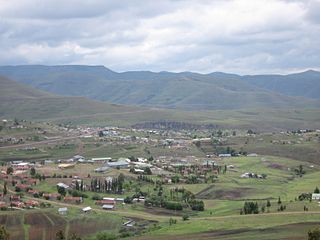
Thaba-Tseka is a district of Lesotho. Thaba-Tseka is also the name of the district's capital or camptown, which is the only town in the district. In the east, Thaba-Tseka borders on the KwaZulu-Natal Province of South Africa. Domestically, it borders on Mokhotlong District in northeast, Leribe District in north, Berea District in northwest, Maseru District in west, Mohale's Hoek District in southwest and Qacha's Nek District in the southern direction. The district is one of the major tourist attractions in Lesotho because of the second largest arch dam in Africa Katse Dam.
Leribè is a district of Lesotho. It has an area of 2,828 km2 and a population in 2016 of approximately 337,500. Hlotse is the capital or camptown of the district. The district has one additional town, namely Maputsoe. In the west, Leribe borders on the Free State Province of South Africa. Domestically, it borders Butha-Buthe District in the north, Mokhotlong District in the east, Thaba-Tseka District in southeast and Berea District in southwest.

Mafeteng is a district of Lesotho. It has an area of 2,119 km2 and a population in 2016 of 178,222. Mafeteng is the capital or camptown, and only town in the district. In the west, Mafeteng borders on the Free State Province of South Africa. Domestically, it borders on the following districts Maseru District in the northeast and Mohale's Hoek District in the southeast.

Maseru is a district of Lesotho. Maseru is also the name of the district's capital, and is the only city in the district and also the capital of the country. It is the largest urban area in the country, and therefore the only city. The city of Maseru is located on Lesotho's western border with the Free State Province of South Africa, the frontier being the Caledon River. Maseru borders on Berea District in north, Thaba-Tseka District in the east, Mohale's Hoek District in south, and Mafeteng District in southwest.

The Highveld is the portion of the South African inland plateau which has an altitude above roughly 1,500 m (4,900 ft), but below 2,100 m (6,900 ft), thus excluding the Lesotho mountain regions to the south-east of the Highveld. It is home to some of the country's most important commercial farming areas, as well as its largest concentration of metropolitan centres, especially the Gauteng conurbation, which accommodates one-third of South Africa's population.
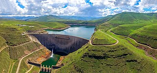
The Katse Dam, a concrete arch dam on the Malibamat'so River in Lesotho, is Africa's second largest double-curvature arch dam after the Tekezé Dam in Ethiopia. Located just below the confluence of the Bokong River, which forms the western arm of the Katse reservoir, the dam is part of a larger project which will eventually include five large dams in remote rural areas.
Phuthi (Síphùthì) is a Nguni Bantu language spoken in southern Lesotho and areas in South Africa adjacent to the same border. The closest substantial living relative of Phuthi is Swati, spoken in Eswatini and the Mpumalanga province of South Africa. Although there is no contemporary sociocultural or political contact, Phuthi is linguistically part of a historic dialect continuum with Swati. Phuthi is heavily influenced by the surrounding Sesotho and Xhosa languages, but retains a distinct core of lexicon and grammar not found in either Xhosa or Sesotho, and found only partly in Swati to the north.

The Lesotho Highlands Water Project (LHWP) is an ongoing water supply project with a hydropower component, developed in partnership between the governments of Lesotho and South Africa. It comprises a system of several large dams and tunnels throughout Lesotho and delivers water to the Vaal River System in South Africa. In Lesotho, it involves the rivers Malibamatso, Matsoku, Senqunyane, and Senqu. It is Africa's largest water transfer scheme.

The Maloti Mountains are a mountain range of the highlands of the Kingdom of Lesotho. They extend for about 100 km into the South African Free State. The Maloti Range is part of the Drakensberg system that includes ranges across large areas of South Africa. "Maloti" is also the plural for Loti, the currency of the Kingdom of Lesotho. The range forms the northern portion of the boundary between the Butha-Buthe District in Lesotho and South Africa's Free State.
The Makhaleng River is a river of western Lesotho. It rises in the Maloti Mountains, flows generally in a southwesterly direction to join the Orange River at the border with Free State in South Africa.
Morija is a town in western Lesotho, located 35 kilometres south of the capital, Maseru. Morija is one of Lesotho's most important historical and cultural sites, known as the Selibeng sa Thuto— the Well-Spring of Learning. It was the site of the first French Protestant mission in Lesotho, founded in 1833. The town also houses the Morija Museum and Archives, well known for supporting research and preserving valuable records and documents of Lesotho's history.
Cannabis in Lesotho is a traditional crop that remains illegal for any use, but largely tolerated. The plant is known as matekoane in Sesotho language but also called khomo ea fatše, likata or kakana.
