
Otago is a region of New Zealand located in the southern half of the South Island administered by the Otago Regional Council. It has an area of approximately 32,000 square kilometres (12,000 sq mi), making it the country's second largest local government region. Its population was 236,200 in June 2019.
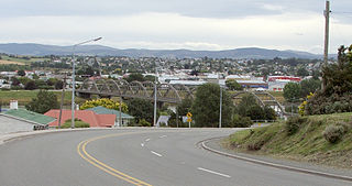
Balclutha is a town in Otago, lying towards the end of the Clutha River, on the east coast of the South Island of New Zealand. It is about halfway between Dunedin and Invercargill on the Main South Line railway, State Highway 1 and the Southern Scenic Route. Balclutha has a population of 4,060, and is the largest town in South Otago.

The Clutha River / Mata-Au is the second longest river in New Zealand and the longest in the South Island. It flows south-southeast 338 kilometres (210 mi) through Central and South Otago from Lake Wanaka in the Southern Alps to the Pacific Ocean, 75 kilometres (47 mi) south west of Dunedin. It is the highest volume river in New Zealand, and the swiftest, with a catchment of 21,960 square kilometres (8,480 sq mi), discharging a mean flow of 614 cubic metres per second (21,700 cu ft/s). The Clutha River is known for its scenery, gold-rush history, and swift turquoise waters. A river conservation group, the Clutha Mata-Au River Parkway Group, is working to establish a regional river parkway, with a trail, along the entire river corridor. The name of the river was changed to a dual name by the Ngai Tahu Claims Settlement Act 1998.

Kaitangata is a town near the coast of South Otago, New Zealand, on the left bank of the Clutha River ten kilometres south east of Balclutha. The town is known to its residents simply as Kai.

The Catlins comprises an area in the southeastern corner of the South Island of New Zealand. The area lies between Balclutha and Invercargill, straddling the boundary between the Otago and Southland regions. It includes the South Island's southernmost point, Slope Point.
South Otago lies in the south east of the South Island of New Zealand. As the name suggests, it forms the southernmost part of the geographical region of Otago.

Clutha District is a local government district of southern New Zealand, with its headquarters in the Otago town of Balclutha. The Clutha District has a land area of 6,362.86 km² and a 2006 census population of 16,839 usual residents. Clutha District occupies the majority of the geographical area known as South Otago.
Inch Clutha is a large, flat island sitting in the delta between the Matau (northern) and Koau (southern) branches of the Clutha River, downstream from the town of Balclutha in the South Island of New Zealand. Approximately 10 kilometres (6 mi) long and 3 kilometres (2 mi) wide, the fertile but flood-prone land of the island is extensively farmed. The island was formed in 1878 after a massive flood changed the course of the Clutha, which had formerly reached the ocean 4 km to the south at Port Molyneux.

Dipton is a small town in the Southland region of New Zealand. It is located 20 kilometres south of Lumsden and 60 kilometres north of Invercargill. From 20 October 1875 until its closure on 13 December 1982, Dipton was situated on the Kingston Branch railway.

Molyneux is a French surname. The surname has been linked primarily to a large French family that settled in Lancashire, United Kingdom from France. By the 14th century the Molyneux family had become so large that it split into three main branches; the Lancashire line, who became the Earls of Sefton, the Nottingham line, and the Calais line, from family still left over in Normandy. There was also a branch of the family who were Irish baronets.
Papatowai is a small settlement in the Catlins ward of the Clutha District of the southeastern South Island of New Zealand. The settlement is situated half-way between the cities of Dunedin and Invercargill, on the Pacific coast close to the mouth of the Tahakopa River. There is a permanent population of around 40 people but with most of the houses in the town being holiday homes the population rises dramatically during the holiday seasons, particularly around New Year's Day and Easter.

State Highway 8 is one of New Zealand's eight national highways. It forms an anticlockwise loop through the southern scenic regions of the Mackenzie Basin and Central Otago, starting and terminating in junctions with State Highway 1. Distances are measured from north to south.
The Molineux Hotel in Wolverhampton is an 18th-century former mansion house known as Molineux House, which later served as a hotel and currently, following restoration serves as a local authority facility. It is a Grade II* listed building.
Clutha was a New Zealand parliamentary electorate from 1866 to 1996.

The Clutha Mata-Au River Parkway Group, New Zealand, was formed in October 2003, and is an Incorporated Society, with Charitable and Donee Status. The Group was set up in response to land development issues along the Clutha Mata-Au River corridor, much of which has high scenic and recreational values. The project aims to establish a regional river parkway, including a river trail, along the entire 338 km river corridor from Lake Wanaka to the Pacific Ocean.
The Pūerua River, prior to 2018 spelled Puerua River, is a river in South Otago, New Zealand. A tributary of the Clutha River, it rises east of Brown Dome and flows eastward to join that river near Port Molyneux.
The Waitepeka River is a river in New Zealand. A tributary of the Clutha River, it flows into that river near Port Molyneux.
State Highway 91 (SH 91) was part of the New Zealand state highway network before briefly becoming part of SH 92 in 1990–91. It ran for 13 kilometres through South Otago in the southern South Island. SH 92 itself had its status revoked a year later.
The Alexandra Bridges refers to the old and new bridges that cross the Clutha River in Alexandra, New Zealand. The bridges are situated at the confluence of the Clutha River/Mata-au River and Manuherikia River.
Port Molyneux is a tiny settlement on the coast of South Otago, New Zealand, close to the northeasternmost point of The Catlins. Now home only to farmland, it was a thriving port in the early years of New Zealand's European settlement.