
O Corgo, is a municipality in the province of Lugo, in the autonomous community of Galicia, Spain. It belongs to the comarca of Lugo.

The Diocese of Rouyn-Noranda is a Latin Church diocese that includes part of the Province of Quebec in the Gatineau ecclesiastical province. The Diocese was erected in November of 1973 from the territory within Quebec of Diocese of Timmins, with Jean-Guy Hamelin as the first Bishop of Rouyn-Noranda.
Pulivendula is a town located in the YSR Kadapa district, Andhra Pradesh, India. It is a small town which became 3rd grade municipality in 2008 from nagar Panchayat.

The Republic of New Granada was a centralist unitary republic consisting primarily of present-day Colombia and Panama with smaller portions of today's Costa Rica, Ecuador, Venezuela, Peru and Brazil that existed from 1831 to 1858. The state was created after the dissolution of Great Colombia in 1830 through the secession of Ecuador and Venezuela. In 1858 the state was renamed into the Granadine Confederation. On 9 May 1834, the national flag was adopted and was used until 26 November 1861, with the Gran Colombian colours in Veles' arrangement. The merchant ensign had the eight-pointed star in white.

La Victoria is a town and municipality in the Colombian Department of Boyacá, part of the subregion of the Western Boyacá Province.
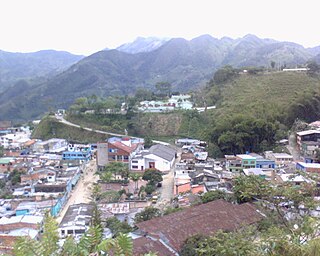
Quípama is a town and municipality in the Colombian Department of Boyacá, part of the subregion of the Western Boyacá Province.

Partido de la Sierra en Tobalina is a municipality located in the province of Burgos, Castile and León, Spain. According to the 2004 census (INE), the municipality has a population of 68 inhabitants. Its seat is in Valderrama.

Nassoumbou is a department or commune of Soum Province in north-western Burkina Faso. Its capital lies at the town of Nassoumbou.
Yoroko is a town in the Zabré Department of Boulgou Province in south-eastern Burkina Faso. As of 2005, the town has a population of 2,439.
Yaco Municipality is the third municipal section of the Loayza Province in the La Paz Department, Bolivia. Its seat is Yaco.
Oulad Yaich is a town in Béni-Mellal Province, Béni Mellal-Khénifra, Morocco. According to the 2004 census it has a population of 7,692.
Cochea is a corregimiento in David District, Chiriquí Province, Panama. It has a land area of 58.8 square kilometres (22.7 sq mi) and had a population of 2,447 as of 2010, giving it a population density of 41.6 inhabitants per square kilometre (108/sq mi). Its population as of 1990 was 1,790; its population as of 2000 was 2,004.
San Pablo Nuevo is a corregimiento in David District, Chiriquí Province, Panama. It has a land area of 59 square kilometres (23 sq mi) and had a population of 1,752 as of 2010, giving it a population density of 29.7 inhabitants per square kilometre (77/sq mi). Its population as of 1990 was 1,192; its population as of 2000 was 1,642.
Río Grande is a corregimiento in Penonomé District, Coclé Province, Panama with a population of 3,117 as of 2010. Its population as of 1990 was 2,411; its population as of 2000 was 2,915.
Santa Ana is a corregimiento in Los Santos District, Los Santos Province, Panama with a population of 3,329 as of 2010. Its population as of 1990 was 2,652; its population as of 2000 was 2,970.
Tres Quebradas is a corregimiento in Los Santos district, Los Santos province, Panama, with a population of 717 in 2010. Its population in 2000 was 665 and in 1990 was 1,646.
El Bebedero is a corregimiento in Tonosí District, Los Santos Province, Panama with a population of 1,332 as of 2010. Its population as of 1990 was 1,227; its population as of 2000 was 1,389.
Guánico is a corregimiento in Tonosí District, Los Santos Province, Panama with a population of 996 as of 2010. Its population as of 1990 was 1,477; its population as of 2000 was 1,006.
Pedro González is one of the Pearl Islands of Panama. It is a corregimiento in Balboa District, Panamá Province with a population of 263 as of 2010, mostly in the village of Pedro de Cocal. Its population as of 1990 was 440; its population as of 2000 was 247.
Barnizal is a corregimiento in Calobre District, Veraguas Province, Panama with a population of 435 as of 2010. Its population as of 1990 was 521; its population as of 2000 was 502.
