This article needs additional citations for verification .(October 2023) |
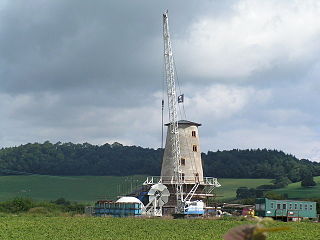
Monkswood (Welsh : Coed y Mynach) is a village in Monmouthshire, south east Wales, United Kingdom.
This article needs additional citations for verification .(October 2023) |
Monkswood (Welsh : Coed y Mynach) is a village in Monmouthshire, south east Wales, United Kingdom.
Monkswood is located two miles west of Usk on the A472 road to Pontypool. It lies parallel to the Berthon Brook, a minor tributary of the River Usk.
Monkswood derives its name from the area of land farmed by monks from Usk in medieval times.
After a battle near Usk, the Battle of Pwll Melyn, during the Owain Glyndŵr rebellion in the early 15th century the Welsh forces were pursued across the River Usk and through Monkswood where many were slaughtered.
BAE Systems, Glascoed, the UK's sole munitions filling and packing facility, is hidden in a wooded valley nearby and to the south of the A472 road.
The village pub was the Beaufort Arms (which finally closed in 2010). [1]

Usk is a town and community in Monmouthshire, Wales, 10 miles (16 km) northeast of Newport. It is located on the River Usk, which is spanned by an arched stone bridge at the western entrance to the town. Usk Castle, above the town, overlooks the ancient crossing point. It developed as a small market town, with some industry including the making of Japanware, and with a notable prison built in 1841/2. In recent years Usk has become known for its history of success in Britain in Bloom competitions, winning the Large Village award in 2005. The resident population of the town in 2001 was 2,318, increasing to 2,834 at the 2011 census.

The River Usk rises on the northern slopes of the Black Mountain, Wales, in the westernmost part of the Brecon Beacons National Park. Initially forming the boundary between Carmarthenshire and Powys, it flows north into Usk Reservoir, then east by Sennybridge to Brecon before turning southeast to flow by Talybont-on-Usk, Crickhowell and Abergavenny after which it takes a more southerly course.

Llanfoist is a village near Abergavenny, in Monmouthshire, Wales, in the community of Llanfoist Fawr. Llanfoist derives from Ffwyst, an early Christian Welsh saint, although the anglicised version of the church patron is Saint Faith. The population was 1,228 in 2011.
Llanelly is the name of a parish and coterminous community in the principal area of Monmouthshire, within the historic boundaries of Brecknockshire, south-east Wales. It roughly covers the area of the Clydach Gorge. The population of the parish and ward at the 2011 census was 3,899.

Blorenge, also called The Blorenge, is a prominent hill overlooking the valley of the River Usk near Abergavenny, Monmouthshire, southeast Wales. It is situated in the southeastern corner of the Brecon Beacons National Park. The summit plateau reaches a height of 561 metres (1,841 ft).

Little Mill is a village in Monmouthshire, south east Wales, United Kingdom, in the community and ward of Goetre Fawr. It has a population of about 600.
Llanbadoc is a village and community in the county of Monmouthshire and the preserved county of Gwent in Wales. The population of the village at the 2011 census was 806.

Gilwern is a village within the Brecon Beacons National Park in Monmouthshire, Wales. Historically in Brecknockshire, it extends to either side of the River Clydach on the south side of the Usk valley. Its position beside the Monmouthshire and Brecon Canal led to it being an important industrial centre at one time.

The Battle of Pwll Melyn, was a battle between the Welsh and English on 5 May 1405, it was part of the Glyndŵr Rising that lasted from 1400 to 1415. It was the first English victory in a pitched battle during the war. The battle resulted in heavy casualties for the Welsh including the loss of 2 important Commanders.

Llanfihangel Gobion is a village and rural parish of Monmouthshire, Wales, lying within the administrative community of Llanover.

Newbridge-on-Usk is a hamlet in the village and parish of Tredunnock, near Usk, Monmouthshire, south east Wales, in the United Kingdom.

LlanoverWelsh pronunciation:[ɬaˈnɔvɛr] is a village in the community of Goetre Fawr in Monmouthshire, Wales.
Llancayo is a village in Monmouthshire, south east Wales, United Kingdom. It is located two miles north of Usk on the B4598 road to Abergavenny, in the community of Gwehelog Fawr.
Llandegveth is a village in Monmouthshire, south east Wales.

Llantrisant is a village in Monmouthshire, south east Wales, United Kingdom. The community population at the 2011 census was 475.
Llanhennock is a village and former community, now in the community of Llangybi, in Monmouthshire, south east Wales, United Kingdom. The population taken at the 2011 census was 496. The village of Tredunnock was within the community. In 2022 the community was abolished and merged with Llangybi.

Gwernesney is a village in Monmouthshire in southeast Wales.
Nant-y-derry is a village in the county of Monmouthshire, Wales, located six miles south east of Abergavenny and four miles northwest of Usk.
The Bryn, or Llangattock Nigh Usk, is a small village on the left bank of the River Usk in Monmouthshire, southeast Wales. It is accessed by a cul-de-sac minor road from the B4598 road, the reclassified former trunk road between Raglan and Abergavenny, now replaced by the modern A40 dual carriageway which runs east–west immediately north of the village. On the western edge of the village is St Cadoc's Church, a Gothic perpendicular style grade II* listed building probably dating from the fifteenth century. The village falls within the administrative community of Llanover. The Usk Valley Walk passes along the riverside path to the south.
51°43′06″N2°57′14″W / 51.71833°N 2.95389°W
| | This article relating to a location in Monmouthshire is a stub. You can help Wikipedia by expanding it. |