Related Research Articles

The Quad Cities is a region of cities in the U.S. states of Iowa and Illinois: Davenport and Bettendorf in southeastern Iowa, and Rock Island, Moline and East Moline in northwestern Illinois. These cities are the center of the Quad Cities metropolitan area, a region within the Mississippi River Valley, which as of 2023 had a population estimate of 467,817 and a Combined Statistical Area (CSA) population of 474,019, making it the 90th-largest CSA in the nation.

Rock Island is a city in and the county seat of Rock Island County, Illinois, United States. The population was 37,108 at the 2020 census. Located at the confluence of the Rock and Mississippi rivers, it is one of the Quad Cities along with neighboring Moline and East Moline in Illinois and the cities of Davenport and Bettendorf in Iowa. The Quad Cities had a population of 384,324 in 2020. The city is home to Rock Island Arsenal, the largest government-owned weapons manufacturing arsenal in the US, which employs 6,000 people. The original Rock Island, from which the city name is derived, is now called Arsenal Island.

Ovid Township is a civil township of Branch County in the U.S. state of Michigan. The population was 2,161 at the 2020 census.
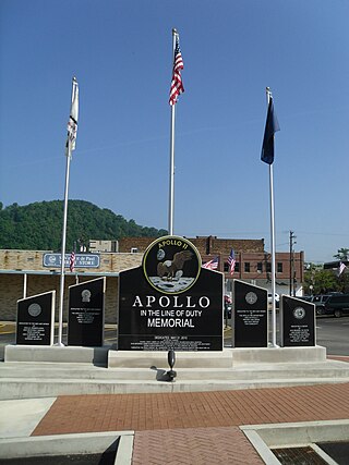
Apollo is a borough in Armstrong County, Pennsylvania, United States, 35 miles (56 km) northeast of Pittsburgh in a former coal-mining region. Apollo was settled in 1790, laid out in 1816, and incorporated as a borough in 1848. The population was 1,615 at the 2020 United States Census

Foxburg is a borough in Clarion County, Pennsylvania, United States. It is located along the east bank of the Allegheny River, about 2 miles (3 km) north of the mouth of the Clarion River. As of the 2020 census it had a population of 181.

Duryea is a borough in the Greater Pittston area of Luzerne County, Pennsylvania, United States, 9 miles (14 km) south of Scranton. The Susquehanna River marks Duryea's western boundary and the Lackawanna River flows through Duryea. It was incorporated as a borough in 1901, and had a notable switching rail yard, the Duryea yard, connecting the central Wyoming Valley to destinations in lower New York and down-state Pennsylvania. Coal mining and silk manufacturing were the chief industries in Duryea's early years. The population was 5,032 at the 2020 census.

Exeter Township is a township within the Greater Pittston area of Luzerne County, Pennsylvania, United States. The population was 2,047 at the 2020 census. Upper Exeter and Harding are two villages in the township.

Hanover Township is a township in Luzerne County, Pennsylvania. As of the 2020 census, the population was 11,424, making it the most populous township in the county.

Larksville is a borough in Luzerne County, Pennsylvania, United States. It is 2 miles (3 km) west of Wilkes Barre on the Susquehanna River. The population was 4,216 as of the 2020 census.

West Pittston is a borough in the Greater Pittston area of Luzerne County, Pennsylvania, United States. It is located on the Susquehanna River. In 2020, the population was 4,644.
West Wyoming is a borough that is located in Luzerne County, Pennsylvania, United States. The borough is part of the Greater Pittston metro area.

White Haven is a borough in Luzerne County, Pennsylvania, United States. It is located along the Lehigh River. The population was 1,163 at the 2020 census.

Wyoming is a borough in the Greater Pittston area of Luzerne County, Pennsylvania, United States. It is located 5 miles (8 km) north of Wilkes-Barre, along the Susquehanna River. The population was 3,097 as of the 2020 census.
Mansfield is a borough located in east-central Tioga County, Pennsylvania, United States, in the Tioga River valley. It is situated at the intersection of U.S. Route 6 and U.S. Business Route 15, about 36 miles (58 km) southwest of Elmira, New York.

Nicholson is a borough in Wyoming County, Pennsylvania. The population was 698 at the 2020 census.
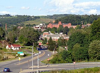
Tunkhannock is a borough and county seat of Wyoming County, Pennsylvania, United States. Located 31 miles northwest of Wilkes-Barre, Tunkhannock is in the Scranton–Wilkes-Barre–Hazleton, PA Metropolitan Statistical Area. In the past, lumbering was carried on extensively. Today, many residents are employed by the Procter & Gamble plant in nearby Washington Township. As of the 2020 census, the borough population was 1,766.

Fort Bridger is a census-designated place (CDP) in eastern Uinta County, Wyoming, United States. The population was 354 at the 2020 census. The community takes its name from the eponymous Fort Bridger, established in 1842, which is located within the boundaries of the CDP.

Cape Fear is a prominent headland jutting into the Atlantic Ocean from Bald Head Island on the coast of North Carolina in the southeastern United States. It is largely formed of barrier beaches and the silty outwash of the Cape Fear River as it drains the southeast coast of North Carolina through an estuary south of Wilmington. Cape Fear is formed by the intersection of two sweeping arcs of shifting, low-lying beach, the result of longshore currents which also form the treacherous, shifting Frying Pan Shoals, part of the Graveyard of the Atlantic.
Hilldale is a census-designated place (CDP) in Plains Township, Luzerne County, Pennsylvania, United States. The population was 1,246 at the time of the 2010 census.
References
- ↑ U.S. Geological Survey Geographic Names Information System: Monocanock Island
- ↑ Murtha, Claudia (11 February 2022). "Wyoming Borough bridge renamed to honor PennDOT employee who died on the job". Fox 56 News. Fox 56 Wolf. Retrieved 16 February 2022.
- ↑ Baca, Keith A. (2007). Native American Place Names in Mississippi. University Press of Mississippi. p. 58. ISBN 978-1-60473-483-6.
41°17′55″N75°50′26″W / 41.29861°N 75.84056°W
| | This Luzerne County, Pennsylvania state location article is a stub. You can help Wikipedia by expanding it. |