
The London Borough of Southwark in South London forms part of Inner London and is connected by bridges across the River Thames to the City of London and London Borough of Tower Hamlets. It was created in 1965 when three smaller council areas amalgamated under the London Government Act 1963. All districts of the area are within the London postal district. It is governed by Southwark London Borough Council.

New Kent Road is a 1 kilometre (0.6 mi) road in the London Borough of Southwark. The road was created in 1751 when the Turnpike Trust upgraded a local footpath. This was done as part of the general road improvements associated with the creation of Westminster Bridge; in effect it was possible to travel from the West End/ Westminster to the south-east without having to go via the Borough of Southwark but could now cross St George's Fields to the junction of Newington Causeway and Newington Butts which is where New Kent Road starts at Elephant & Castle. The route runs eastward for a few hundred yards to the junction of Great Dover Street and Tower Bridge Road, known as Bricklayers Arms, where it joins the original route to the south-east Old Kent Road.

Borough Market is a wholesale and retail market hall in Southwark, London, England. It is one of the largest and oldest food markets in London, with a market on the site dating back to at least the 12th century. The present buildings were built in the 1850s, and today the market mainly sells speciality foods to the general public.
The Metropolitan Borough of Southwark was a metropolitan borough in the County of London from 1900 to 1965. It was created to cover the western section of the ancient borough of Southwark and the parish of Newington. In common with the rest of inner London, the borough experienced a steady decline in population throughout its existence. The borough council made an unsuccessful attempt to gain city status in 1955. Its former area is now the northwestern part of the current London Borough of Southwark.

Bankside is an area of London, England, within the London Borough of Southwark. Bankside is located on the southern bank of the River Thames, 1.5 miles (2.4 km) east of Charing Cross, running from a little west of Blackfriars Bridge to just a short distance before London Bridge at St Mary Overie Dock. It is part of a business improvement district known as 'Better Bankside'.
The Worshipful Company of Glaziers and Painters of Glass is one of the livery companies of the City of London. The Guild of Glaziers, or makers of Glass, the company's forerunner, existed as early as the fourteenth century. It received a royal charter of incorporation in 1638. It is no longer a trade association of glass craftsmen, instead existing, along with a majority of livery companies, as a charitable body.

Borough High Street is a road in Southwark, London, running south-west from London Bridge, forming part of the A3 route which runs from London to Portsmouth, on the south coast of England.
Tooley Street is a road in central and south London connecting London Bridge to St Saviour's Dock; it runs past Tower Bridge on the Southwark/Bermondsey side of the River Thames, and forms part of the A200 road.
The Cuming Museum in Walworth Road in Elephant and Castle, within the London Borough of Southwark, London, England, was a museum housing the collection of the Cuming family and later collections on Southwark's history. As of 2021, its collections have been rehoused in a new Southwark Heritage Centre.

Borough Road is in Southwark, London SE1. It runs east–west between St George's Circus and Borough High Street.

Southwark College is a further education college located in the London Borough of Southwark. The college at one time had seven sites; it is now based at a building on The Cut, opposite Southwark tube station. The college has been part of Newcastle College Group since 2017.

Southwark Bridge Road is a road in Southwark, London, England, between Newington Causeway near Elephant and Castle and Southwark Bridge across the River Thames, leading to the City of London, in a meandering route.

Union Street is a major street in the London Borough of Southwark. It runs between Blackfriars Road to the west and Borough High Street to the east. Southwark Bridge Road crosses in the middle.

Bermondsey and Old Southwark is a constituency in the House of Commons of the UK Parliament. Since 2015, it has been represented by Neil Coyle, who was elected as a Labour MP but was suspended from the party from 2022 to 2023 following an accusation of racism.

Long Lane is a main east–west road in Southwark, south London, England.

The Wheatsheaf is a public house at 6 Stoney Street, Borough, Southwark, London. Established in the 18th century, it has become a prominent landmark and a popular drinking establishment in the area, known for its rich history and traditional pub atmosphere.

One The Elephant is a residential apartment development, in Elephant & Castle in the London Borough of Southwark, centred around a 37-storey 124m tall tower. At the base of the tower is an adjoining four-storey L-shaped pavilion containing apartments and commercial units. The development lies immediately adjacent to the Metropolitan Tabernacle and in close proximity to Elephant & Castle tube station.

St Saviour's War Memorial is a war memorial on Borough High Street, in the former parish of Southwark St Saviour, to south of the River Thames in London. It became a Grade II listed building in 1998 and was upgraded to Grade II* in 2018.

Highpoint is a 142-metre, 46-storey, 458-apartment residential tower in Elephant and Castle in the London Borough of Southwark in London on the site of the London Park Hotel.
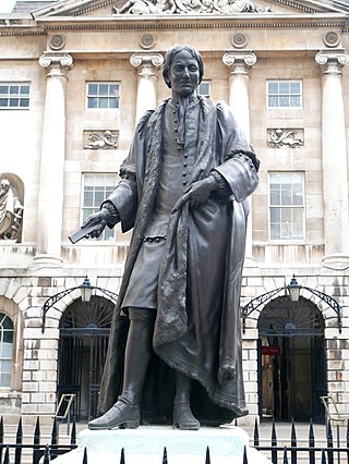
A statue of Thomas Guy stands in the forecourt of Guy's Hospital in the borough of Southwark in Central London. The statue is Grade II listed.


