This article may be expanded with text translated from the corresponding article in Italian. (May 2010)Click [show] for important translation instructions.
|
| Monte Costa Calda | |
|---|---|
 Monte Costa Calda Location in Italy | |
| Highest point | |
| Elevation | 1,166 m (3,825 ft) |
| Coordinates | 40°24′49″N15°02′07″E / 40.41361°N 15.03528°E Coordinates: 40°24′49″N15°02′07″E / 40.41361°N 15.03528°E |
| Geography | |
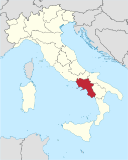
| Location | Campania, Italy |
Monte Costa Calda is a mountain in the region of Campania, Italy.

A mountain is a large landform that rises above the surrounding land in a limited area, usually in the form of a peak. A mountain is generally steeper than a hill. Mountains are formed through tectonic forces or volcanism. These forces can locally raise the surface of the earth. Mountains erode slowly through the action of rivers, weather conditions, and glaciers. A few mountains are isolated summits, but most occur in huge mountain ranges.
Campania is a region in Southern Italy. As of 2018, the region has a population of around 5,820,000 people, making it the third-most-populous region of Italy; its total area of 13,590 km2 (5,247 sq mi) makes it the most densely populated region in the country. Located on the Italian Peninsula, with the Mediterranean Sea to the west, it includes the small Phlegraean Islands and Capri for administration as part of the region.

Italy, officially the Italian Republic, is a country in Southern Europe. Located in the middle of the Mediterranean Sea, Italy shares open land borders with France, Switzerland, Austria, Slovenia and the enclaved microstates San Marino and Vatican City, as well as a maritime border with Croatia. Italy covers an area of 301,340 km2 (116,350 sq mi) and has a largely temperate seasonal and Mediterranean climate. With around 61 million inhabitants, it is the fourth-most populous EU member state and the most populous country in Southern Europe.
| This Campanian location article is a stub. You can help Wikipedia by expanding it. |