Monte San Cristoforo

Last updated

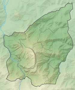
Monte San Cristoforo is a mountain of southern San Marino. [1] It is located between the towns of Fiorentino and Montegiardino, and rises to a height of 534 metres.

Coordinates: 43°54′25″N12°27′53″E / 43.90694°N 12.46472°E / 43.90694; 12.46472

Related Research Articles

San Marino Country in Southern Europe enclaved by Italy

San Marino, officially the Republic of San Marino, also known as the Most Serene Republic of San Marino, is a small country in Southern Europe enclaved by Italy. Located on the northeastern side of the Apennine Mountains, San Marino covers a land area of just over 61 km2 (24 sq mi), and has a population of 33,562.

Geography of San Marino

San Marino is located in Southern Europe, an enclave (landlocked) in central Italy, which it borders for 39 km. The third smallest independent state by area in Europe after the Vatican City and Monaco, San Marino is dominated by the Apennines. Located at 43.94°N 12.46°E, it covers an area of 61.2 km2 (23.6 sq mi). Completely mountainous, only 17% of its territory is arable. Several rivers flow through the country, the largest being the Ausa, the Marano, and the San Marino River.

City of San Marino Castello in San Marino

The City of San Marino is the capital city of the Republic of San Marino. It has a population of 4,061. It is on the western slopes of San Marino's highest point, Monte Titano.

Serravalle (San Marino) Castello in San Marino

Serravalle is a castello in northern San Marino. With a population of 10,878 inhabitants and an area of 10.53 km2, it is not only the most densely populated municipality in San Marino, but it also contains its largest settlement (Dogana). Serravalle is located on the edge of the Apennine Mountains.

Marecchia

The Marecchia is a river in eastern Italy. In ancient times it was known as the Ariminus which was from the Greek Aríminos. The source of the river is near Monte dei Frati which is east of Pieve Santo Stefano and southwest of Badia Tedalda in the province of Arezzo in Tuscany. It flows northeast into the province of Pesaro and Urbino in the Marche and is the only river that runs through Montefeltro. While flowing through Montefeltro, the river flows through the exclave Santa Sofia Marecchia, which belongs to Badia Tedalda. The river then flows past Sant'Agata Feltria and Novafeltria before crossing into the province of Rimini in Emilia–Romagna. At Torello, part of the commune of San Leo, it flows 1 km west of the Sammarinese territory Acquaviva and the San Marino River flows into it, but the Marecchia does not touch the San Marino border. Finally, the river flows past Verucchio and Santarcangelo di Romagna before flowing into the Adriatic Sea near Rimini.

Borgo Maggiore Castello in San Marino

Borgo Maggiore is one of the 9 communes or castelli of San Marino. It lies at the foot of Monte Titano and has a population of 6,871, making it the second largest town of San Marino, after Dogana.

Acquaviva (San Marino) Castello in San Marino

Acquaviva is one of the 9 communes or castelli of San Marino.

Faetano Castello in San Marino

Faetano is one of the 9 communes or castelli of San Marino. It has 1,177 inhabitants in an area of 7.75 km2.

Fiorentino Castello in San Marino

Fiorentino is one of the 9 communes or castelli of the Republic of San Marino. It has 2,548 inhabitants in an area of 6.57 km2.

Montegiardino Castello in San Marino

Montegiardino is one of the 9 communes or castelli of San Marino. It has 967 inhabitants in an area of 3.31 km2.

Extreme points of San Marino

This is a list of the extreme points of San Marino: the points that are farther north, south, east or west than any other location.

Monte Titano A mountain of the Apennines and the highest peak in San Marino

Monte Titano is a mountain of the Apennines and the highest peak in San Marino. It stands 739 m (2,425 ft) above sea level and is located immediately to the east of the capital, San Marino. It was inscribed as a UNESCO World Heritage Site in 2008 under the combined title "San Marino Historic Centre and Mount Titano". Inscribed under reference no. 1245 criteria iii, the two together encompass an area of 55 ha with a buffer zone of 167 ha. It encompasses Mount Titano and the other structures such as the fortification towers, walls, gates and bastions, as well as a neo-classical basilica located on it and its slopes forming a small but unique urban conglomerate.

De La Fratta

De La Fratta, also known as Cesta, is one of three towered peaks overlooking the city of San Marino, the capital of San Marino. The other two are Guaita and Montale.

Guaita

Guaita is one of three towered peaks overlooking the city of San Marino, the capital of San Marino. The other two are De La Fratta and Montale.

Three Towers of San Marino Group of towers located in San Marino

The Three Towers of San Marino are a group of towers located in San Marino. Located on the three peaks of Monte Titano in the capital, also called San Marino, they are depicted on both the national flag and coat of arms.

Outline of San Marino Overview of and topical guide to San Marino

The following outline is provided as an overview of and topical guide to San Marino:

Index of San Marino–related articles Wikipedia index

This page list topics related to San Marino.

Torraccia Village in Domagnano, San Marino

Torraccia is a small village (curazia) located in San Marino. It belongs to the municipality (castello) of Domagnano.

Dragoon Wash, a stream tributary to the San Pedro River, in Cochise County, Arizona. It has its source just southwest of the town of Dragoon. 32°01′21″N110°02′46″W It runs southwesterly to meet the San Pedro River.

Calligaria is a small village (curazia) of San Marino. It belongs to the municipality of Faetano.

References

  1. LLC, General Books (2010-11-24). Landforms of San Marino: Mountains of San Marino, Rivers of San Marino, Monte Titano, Montale, Guaita, San Marino River, Marano, Fiumicello. General Books LLC. ISBN   978-1-157-86710-4.