
San Antonio, officially the City of San Antonio, is the seventh-most populous city in the United States, second largest city in the Southern United States, and the second-most populous city in Texas with 1,434,625 residents in 2020. Founded as a Spanish mission and colonial outpost in 1718, the city became the first chartered civil settlement in present-day Texas in 1731. The area was still part of the Spanish Empire, and later of the Mexican Republic. It is the state's oldest municipality, having celebrated its 300th anniversary on May 1, 2018.

The Town of Danville is located in the San Ramon Valley in Contra Costa County, California. It is one of the incorporated municipalities in California that use "town" in their names instead of "city". The population was 42,039 at the 2010 census. In 2020, Danville was named "the safest town in California".
Hawthorne is a city in the Los Angeles metropolitan area, located in southwestern Los Angeles County, California. It is part of a seventeen-city region commonly called the South Bay. As of the 2010 US census, Hawthorne had a population of 84,293. In 2019, the population was estimated at 86,068.

Balcones Heights is a city in Bexar County, Texas, United States. The population was 2,941 at the 2010 census, and it was incorporated in 1948. Balcones Heights is an enclave of San Antonio, surrounded entirely by the city, thus some residents and out-of-town visitors erroneously consider it merely a neighborhood of the larger city rather than its own unique community which did so to prevent annexation.

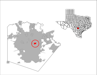
Olmos Park is a wealthy enclave city located in Bexar County, Texas, United States. The population was 2,237 at the 2010 census. Olmos Park is home to billionaire businessmen Red McCombs, Rodney Lewis and AT&T chairman and CEO Randall L. Stephenson. Former Southwest Airlines CEO and cofounder, Herb Kelleher, also owned an estate in Olmos Park until his death in January 2019. The town is noted for its large estates, many of which were constructed during the 1920s, park-like setting, and oak-tree lined streets The town is four miles north of downtown San Antonio and is surrounded by the city of San Antonio on the west, north, and south side.
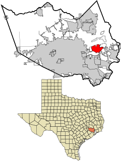
Terrell Hills is a city in Bexar County, Texas, United States; it is located 5 miles (8 km) northeast of downtown San Antonio. As of the 2010 census Terrell Hills had a population of 4,878. It is part of a group of three cities — Terrell Hills, Alamo Heights, and Olmos Park — located between Uptown San Antonio, Midtown San Antonio, Downtown San Antonio, and Fort Sam Houston. Terrell Hills is bordered on the west by Alamo Heights, on the east by Fort Sam Houston, on the north by Uptown San Antonio, and on the south by San Antonio's Near East Side. It is part of the San Antonio Metropolitan Statistical Area.
Channelview is a census-designated place (CDP) in the U.S. state of Texas within the Houston–The Woodlands–Sugar Land metropolitan area and Harris County. The population was 38,289 at the 2010 U.S. census.
Uptown is a business district in Houston, located 6.2 miles (10.0 km) west of Downtown and is centered along Post Oak Boulevard and Westheimer Road. The Uptown District is roughly bounded by Woodway Drive to the north, the I-610 to the east, Richmond Avenue to the south, and Yorktown Street to the west. It covers 1,010 acres (410 ha).
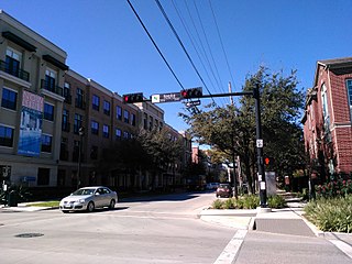
Midtown is a central neighborhood of Houston, located west-southwest of Downtown. Separated from Downtown by an elevated section of Interstate 45, Midtown is characterized by a continuation of Downtown's square grid street plan, anchored by Main Street and the METRORail Red Line. Midtown is bordered by Neartown (Montrose) to the west, the Museum District to the south, and Interstate 69 to the east. Midtown's 325 blocks cover 1.24 square miles (3.2 km2) and contained an estimated population of nearly 8,600 in 2015.
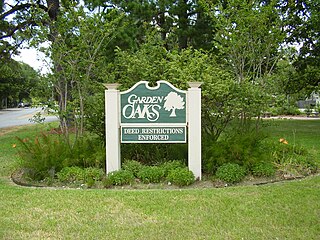
Garden Oaks is a neighborhood in Houston, Texas (USA). The neighborhood, located north of Houston Heights, was established in 1937 by Edward L. Crain.
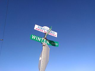
The First Ward of Houston, which is located inside the 610 Loop, is one of the city's historic wards. It was originally the center of the business district for the city, and was strategically located at the intersection of Buffalo Bayou and White Oak Bayou, near an area now known as Allen's Landing. It was one of the original four wards in Houston when it was created in 1840. It was defined as all area within the city limits of Houston north of Congress Street and west of Main Street.

Keystone School, generally called Keystone, is a co-educational independent private school for students from pre-kindergarten to twelfth grade, located in the Monte Vista Historic District in Midtown San Antonio, Texas, USA. The greater Keystone School consists of the Little School of Keystone, serving PK-3 and PK-4 students, Lower School, serving kindergarten through fourth-grade students, the Middle School, serving fifth- through eighth-grade students, and the Upper School, consisting of the ninth through twelfth grades. Keystone is regarded as one of the most academically competitive schools in the United States and has been acclaimed for its academic performance. It has been placed as one of the best private high schools in America by the Washington Post multiple times and ranked #1 in 2015.
Thomas A. Edison High School is a public high school serving the Monte Vista Historic District of San Antonio, Texas . Thomas Edison High School has an enrollment of approximately 1700 students, with a faculty to student ratio of 16.75. It is in the San Antonio Independent School District.
St. Anthony Catholic High School is a private, Roman Catholic high school located in the Monte Vista Historic District in Midtown San Antonio, Texas, United States. It is located in the Roman Catholic Archdiocese of San Antonio.

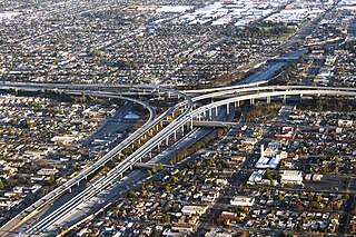
Downtown San Antonio is the central business district of San Antonio, Texas, United States. It also serves as the urban core of Greater San Antonio, a metropolitan area with nearly 2.5 million people. In addition to being encircled by Loops 1604 and 410, Downtown San Antonio is encircled by three Interstate freeways: I-35, I-37, and I-10. Together, the three highways create a rectangular route around the city's urban core: I-35 to the north and west, I-37 to the east, and I-10 to the south. The rectangular loop has a nine-mile circumference and is known as the "Downtown Loop" or "Central Loop", which encompasses both it and Southtown.

East Downtown Houston (EaDo) is a district in Houston, Texas, United States. The East Downtown Management District (EDMD), manages the area with offices headquartered at START Houston, a co-working space 1121 Delano Street. The community is located east of Downtown Houston and north of Interstate 45. It is between the George R. Brown Convention Center and the East End district.

Alamo Heights is an incorporated city that is surrounded by the city of San Antonio in Bexar County in the U.S. state of Texas. At the time of the 2010 census, the population of Alamo Heights was 7,031. It is part of the Greater San Antonio metropolitan area. A portion of the University of the Incarnate Word is in Alamo Heights.

St. Anthony Catholic School is a private, Roman Catholic coeducational school located in the Monte Vista Historic District in Midtown San Antonio, Texas, United States. It is located in the Roman Catholic Archdiocese of San Antonio.
