Monti Gemelli

Last updated

Monti Gemelli (Twin Mountains) is the name given to two similar mountains, Montagna dei Fiori and Montagna dei Campli, in the Abruzzo region of Italy. They are located in the Province of Teramo.

Montagna dei Fiori mountain in Italy

Montagna dei Fiori is a mountain group in the Abruzzo, central Italy, forming the Monti Gemelli massif, together with the Montagna di Campli. It is located nearby the boundary between the province of Teramo and the Marche region; due to its proximity to Ascoli Piceno, it is also known as Montagna d'Ascoli.

Abruzzo Region of Italy

Abruzzo is a region of Southern Italy with an area of 10,763 square km and a population of 1.2 million. It is divided into four provinces: L'Aquila, Teramo, Pescara, and Chieti. Its western border lies 80 km (50 mi) east of Rome. Abruzzo borders the region of Marche to the north, Lazio to the west and south-west, Molise to the south-east, and the Adriatic Sea to the east. Geographically, Abruzzo is divided into a mountainous area in the west, which includes the Gran Sasso d'Italia, and a coastal area in the east with beaches on the Adriatic Sea.

Italy republic in Southern Europe

Italy, officially the Italian Republic, is a country in Southern Europe. Located in the middle of the Mediterranean Sea, Italy shares open land borders with France, Switzerland, Austria, Slovenia and the enclaved microstates San Marino and Vatican City, as well as a maritime border with Croatia. Italy covers an area of 301,340 km2 (116,350 sq mi) and has a largely temperate seasonal and Mediterranean climate. With around 61 million inhabitants, it is the fourth-most populous EU member state and the most populous country in Southern Europe.

Contents

Description

The two peaks are located on the eastern side of the Monti della Laga mountain range, and they are separated by a gorge carved by the Salinello stream. The northern mountain, Montaga dei Fiori, has a slope descending into the Province of Ascoli Piceno. These mountains are also associated with the herb Field Wort (known in Latin as herba gentiana) which, according to the Pseudo-Apuleius Herbal, is useful against snake bite. [1]

Monti della Laga mountain

Monti della Laga is a mountain range in the central Apennines of Italy. Their ruggedness and inaccessibility makes them one of the lesser known areas of the Italian peninsula.

Salinello river in Italy

The Salinello is a river in Italy. It is located in the province of Teramo in the Abruzzo region of southern Italy. The source of the river is in the Monti della Laga range southwest of Montagna dei Fiori. The river flows eastward and curves northeast near Civitella del Tronto. The river then curves southeast near Sant'Egidio alla Vibrata and the border with the province of Ascoli Piceno. Finally, the river flows east near Sant'Omero and enters the Adriatic Sea near Giulianova and Tortoreto Lido.

Province of Ascoli Piceno Province of Italy

The province of Ascoli Piceno is a province in the Marche region of Italy. Its capital is the city of Ascoli Piceno, and the province is bordered by the Adriatic Sea to the east, the province of Macerata to the north, and it faces the regions of Umbria and Abruzzo (Abruzzi) to the south. There are 33 comuni in the province, see Comunes of the Province of Ascoli Piceno.

See also

Apennine Mountains mountain range stretching 1000 km from the north to the south of Italy along its east coast, traversing the entire peninsula, and forming the backbone of the country

The Apennines or Apennine Mountains are a mountain range consisting of parallel smaller chains extending c. 1,200 km (750 mi) along the length of peninsular Italy. In the northwest they join with the Ligurian Alps at Altare. In the southwest they end at Reggio di Calabria, the coastal city at the tip of the peninsula. Since 2000 the Environment Ministry of Italy, following the recommendations of the Apennines Park of Europe Project, has been defining the Apennines System to include the mountains of north Sicily, for a total distance of 1,500 kilometres (930 mi). The system forms an arc enclosing the east side of the Ligurian and Tyrrhenian Seas.

Related Research Articles

Province of Teramo Province of Italy

The Province of Teramo is a province in the Abruzzo region of Italy. Its capital is the city of Teramo. The province has an area of 1,948 square kilometres (752 sq mi), a population of 313,029 (2012), and is subdivided into 47 comunes, see Comunes of the Province of Teramo. The Province of Teramo shares its northern border with the Province of Ascoli Piceno in the Marche Region, southern and southwestern borders with the Province of L'Aquila in the Abruzzo Region, and a western border with the Province of Rieti in the Region of Lazio. To the south is the Abruzzo Province of Pescara and to the east is the Adriatic Sea.

Province of Rieti Province of Italy

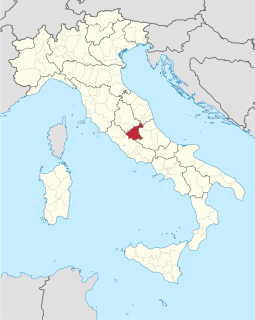
The Province of Rieti is a province in the Lazio region of Italy. Its capital is the city of Rieti. Established in 1927, it has an area of 2,750.52 square kilometres (1,061.98 sq mi) with a total population of 157,887 people as of 2017. There are 73 comuni in the province.

Aterno-Pescara river in Italy

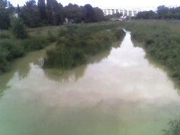
The Aterno-Pescara is a river system in Abruzzo, eastern central Italy. The river is known as the Aterno near its source in the mountains, but takes the name Pescara, actually a tributary, nearer the city of Pescara and the Adriatic Sea.

Frondarola human settlement in Teramo, Province of Teramo, Abruzzo, Italy

Frondarola is a small town in the province of Teramo in the Abruzzo region of Italy, population about 200. It lies at an altitude of 1502 feet above sea level and is located about 5 miles from Teramo, of which it is a frazione.

Civitella del Tronto Comune in Abruzzo, Italy

Civitella del Tronto is a town and comune in the province of Teramo, within the Abruzzo region of central Italy. It is located in the Gran Sasso e Monti della Laga National Park.

Valle Castellana Comune in Abruzzo, Italy

Valle Castellana is a village and comune in the Province of Teramo, in the Abruzzo region of central Italy. It is a member of the Italian community of surrounding mountain villages, Monti della Laga. It is located in the natural park known as the Gran Sasso e Monti della Laga National Park.

Padula (Cortino) Frazione in Abruzzo, Italy

Padula is a small village in the Province of Teramo, in the Abruzzo region of central Italy. It is a hamlet (frazione) of the commune of Cortino.

Gran Sasso e Monti della Laga National Park Italian national park

The Gran Sasso and Monti della Laga National Park is a natural park located mostly in Abruzzo, Italy. Established in 1991, it has an area of 2,014 square kilometres (778 sq mi), and it is mainly spread out across the province of Teramo, L'Aquila, Pescara, with small areas in the province of Rieti and Ascoli Piceno. The terrain is predominantly mountainous with alpine plains.

San Giacomo (Valle Castellana) human settlement in Valle Castellana, Province of Teramo, Abruzzo, Italy

San Giacomo is a mountain village in the Province of Teramo in the Abruzzo region of Italy. It is a frazione of the comune of Valle Castellana.

Tronto Italian river

The Tronto is a 115-kilometre (71 mi) long Italian river that arises at Monti della Laga and ends in the Adriatic Sea at Porto d'Ascoli, San Benedetto del Tronto. It traverses the Lazio, Marche, and Abruzzo regions of Italy.

Valle Pezzata human settlement in Valle Castellana, Province of Teramo, Abruzzo, Italy

Valle Pezzata is a village in the Abruzzo region of central Italy. It is a frazione of the comune of Valle Castellana. The village lies in an area known as Monti della Laga, deep within the Gran Sasso e Monti della Laga National Park.

Martese Frazione in Abruzzo, Italy

Martese is a "frazione" (hamlet) in the commune of Rocca Santa Maria in the Province of Teramo, Italy.

Serra (Rocca Santa Maria) Frazione in Abruzzo, Italy

Serra is an Italian village and frazione of the Commune of Rocca Santa Maria in the Province of Teramo, Abruzzo, Italy. The village sits at an elevation of 3596 feet above sea level in the area of Monti della Laga within the Gran Sasso e Monti della Laga National Park.

Monsampietro Frazione in Marche, Italy

Monsampietro is a frazione (hamlet) of the comune (municipality) of Venarotta in the province of Ascoli Piceno in the Italian region Marche. The territory is part of Diocese of Ascoli Piceno.

Mavone italian river

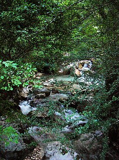
The Mavone is a river in Italy. It is located in the province of Teramo in the Abruzzo region of southern Italy. The river is the main tributary of the Vomano. Its source is in the Gran Sasso e Monti della Laga National Park near Corno Grande. The river flows northeast near Isola del Gran Sasso d'Italia and Colledara before joining the Vomano near Basciano.

Castellano (river) river in Italy

The Castellano is a river in Italy. Its source is in the Monti della Laga mountains near the border between the province of Teramo and the province of Rieti north of Monte Gorzano. It flows northeast through the mountains in the province of Teramo and eventually forms the border between the province of Teramo and the province of Ascoli Piceno. The river flows west of Monte dei Fiori before entering the province of Ascoli Piceno. The river joins the Tronto at Ascoli Piceno.

Montagna may refer to:

References

The Old English Herbarium and Medicina de Quadrupedibus, The Early English Text Society, Oxford University Press: London, 1984.

  1. The Old English Herbarium and Medicina de Quadrupedibus

Coordinates: 42°45′49″N13°35′53″E / 42.76361°N 13.59806°E / 42.76361; 13.59806

Geographic coordinate system Coordinate system

A geographic coordinate system is a coordinate system that enables every location on Earth to be specified by a set of numbers, letters or symbols. The coordinates are often chosen such that one of the numbers represents a vertical position and two or three of the numbers represent a horizontal position; alternatively, a geographic position may be expressed in a combined three-dimensional Cartesian vector. A common choice of coordinates is latitude, longitude and elevation. To specify a location on a plane requires a map projection.