Adjala–Tosorontio is a township in south-central Ontario, Canada, in the County of Simcoe.
Johnstone Creek Provincial Park is a provincial park in British Columbia, Canada, located west of the confluence of Rock Creek and the Kettle River and the town of Rock Creek. The park has roughly 38ha area, and is fairly near to the Crowsnest Highway.
Mehatl Creek Provincial Park is a provincial park in British Columbia, Canada, located in the central Lillooet Ranges to the west of Boston Bar.
Stuart River Provincial Park is a provincial park in British Columbia, Canada. It is located in two sections north and northwest of Vanderhoofalong the Stuart River southeast of Stuart Lake and the city of Fort St. James. The upper section is located at 54°13′20″N124°00′00″W and comprises c.7391 ha. while the lower, eastern section is centred at 54°03′00″N123°37′00″W and comprises c.3390 ha. and is within the Greater Prince George area. The upper site, which is located around the confluence of the Stuart and Nechako Rivers, includes the site of Chinlac, a Dakelh village whose inhabitants were massacred and enslaved by the Tsilhqot'in of Anahim Lake c. 1745.
Tsintsunko Lakes Provincial Park is a provincial park in British Columbia, Canada. It is located south of the Deadman River between Kamloops (SE) and Bonaparte Lake (NW).
Taylor Arm Provincial Park is a provincial park in British Columbia, Canada, located on the north side of Sproat Lake 23 km northwest of Port Alberni on Vancouver Island. Situated along Highway 4, the 71-hectare park has few services but provides group camping sites, undeveloped beaches, and day-use areas.
There are several lakes named Mud Lake within the Canadian province of Alberta.

Lake Lashaway is a 293-acre (1.19 km2) pond located near the East Brookfield and North Brookfield, Massachusetts town line. The town line cuts the lake approximately in half. The lake lies just to the north of state Route 9 as it passes through East Brookfield.
The East Brookfield River is a 2.4-mile-long (3.9 km) river in Massachusetts that heads at Lake Lashaway in East Brookfield at an elevation of 614 feet (187 m) above sea level. It continues to Quaboag Pond, at an elevation of 594 feet (181 m).

The Bonaparte Indian Band a.k.a. Bonaparte First Nation, is a member band of the Shuswap Nation Tribal Council of the Secwepemc (Shuswap) people.
The Skeetchestn Indian Band is a member of the Secwepemc (Shuswap) Nation, located in the Central Interior region of the Canadian province of British Columbia. Its main Indian reserve is located at Savona, British Columbia. The reserve was set up in the 1860s when the government of the then-Colony of British Columbia established an Indian Reserve system. The Skeetchestn is a member government of the Shuswap Nation Tribal Council.
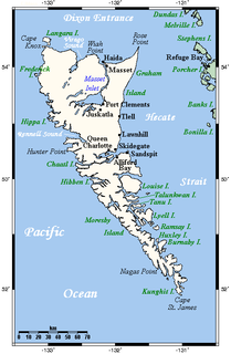
The Colony of the Queen Charlotte Islands was a British colony constituting the archipelago of the same name from 1853 to July 1863, when it was amalgamated into the Colony of British Columbia.
Gold Harbour, was a gold and silver mine and camp on Mitchell Inlet, part of Tasu Sound on Moresby Island in the Queen Charlotte Islands of the North Coast of British Columbia, Canada. It is notable as the location of the first lode mine worked in what is now British Columbia.
Thompson Sound is a sound on the Central Coast of British Columbia, Canada, located on the east side of Tribune Channel and to the east of Gilford Island, part of the Broughton Archipelago. The headland on the north side of the sound's entrance is London Point at 50°46′09″N126°07′07″W. The south side of the entrance is demarcated by Cleave Point at 50°44′35″N126°07′28″W.
Tasu Sound is a large sound on the west coast of Moresby Island in the Queen Charlotte Islands of British Columbia, Canada. It has several smaller bodies of water within its reaches, including Gold Harbour, the location of Gold Harbour, British Columbia. Also on the shores of the sound is Tasu, a former iron mining town also known as Tasoo.
Lone Rock is a hamlet in the Canadian province of Saskatchewan. Listed as a designated place by Statistics Canada, the hamlet had a population of 83 in the Canada 2006 Census.
The Leq' a: mel First Nation, formerly known as the Lakahahmen First Nation, is a First Nations band government whose community and offices are located in the area near Deroche, British Columbia, Canada, about 12 kilometres east of the District of Mission. They are a member government of the Sto:lo Nation tribal council, which is one of two tribal councils of the Sto:lo.

The Chevrolet Silverado 250 is a NASCAR Gander Outdoors Truck Series race, held at Canadian Tire Motorsport Park (Mosport). It was first held in 2013. Starting in 2018, the race became a playoff race and was held as the opener of the playoffs. In 2019, it will be the second race of the first round of the playoffs.
Long Lake is a lake south of the head of Smith Inlet in the Central Coast region of British Columbia, Canada.
The Fawnie Range is a small hill-range located to the south of the Ootsa Lake reservoir and to the north of the West Road River in the Nechako Plateau region of the Central Interior of British Columbia, Canada. The northwest part of the park is within Entiako Provincial Park and includes Mount Swannell,, one of the range's main summits, overlooking Natalkuz Lake from the south. Other named summits include Tutial Mountain, Fawnie Dome and Fawnie Nose, the highest summit in the range.