
Afonso de Albuquerque, Duke of Goa, was a Portuguese general, a "great conqueror", a statesman, and an empire builder.

Vasco da Gama, 1st Count of Vidigueira, was a Portuguese explorer and the first European to reach India by sea. His initial voyage to India (1497–1499) was the first to link Europe and Asia by an ocean route, connecting the Atlantic and the Indian oceans and therefore, the West and the Orient.

Old Goa or Velha Goa is a historical city in North Goa district in the Indian state of Goa. The city was constructed by the Bijapur Sultanate in the 15th century and served as capital of Portuguese India from the 16th century until its abandonment in the 18th century due to a plague. Under the Portuguese, it is said to have once been a city of nearly 200,000 wherefrom, before the plague, the Portuguese traded across continents. The remains of the city are a UNESCO World Heritage Site. Old Goa is approximately 10 kilometres east of the state capital Panaji.

Panaji, also known as Panjim, is the capital of the Indian state of Goa and the headquarters of North Goa district. It lies on the banks of the Mandovi River estuary in the Ilhas de Goa sub-district (taluka). With a population of 114,759 in the metropolitan area, Panjim is Goa's largest Urban agglomeration, ahead of Margão and Vasco da Gama.

The State of India, also referred as the Portuguese State of India or simply Portuguese India, was a state of the Portuguese Overseas Empire, founded six years after the discovery of a sea route between Portugal and the Indian Subcontinent to serve as the governing body of a string of Portuguese fortresses and colonies overseas.

Raj Bhavan is a residential palace and fort situated in Dona Paula, Goa which serves as the official residence of the Governor of Goa. The sprawling 88 acres estate is located on a cape in the Goan capital, Panjim. Known by the name "Palacio do Cabo" until it gained official status as the residence of the governor of Goa, this palace is said to be built between the 16th and 17th century in the erstwhile Portuguese India. The fort is strategically positioned facing the Arabian sea opposite the well-preserved 17th century Forte Aguada.

The Zuari River is the largest river in the state of Goa, India. It is a tidal river. The Zuari originates at Hemad-Barshem in the Western Ghats. The Zuari is also referred to as the Aghanashani in the interior regions. It flows in the southern-western direction through the talukas of Tiswadi, Ponda, Mormugao, Salcete, Sanguem and Quepem.

South Goa is one of two districts that comprises the state of Goa in West India, within the region known as the Konkan. It is bounded by the district of North Goa to the north, the Uttara Kannada district of Karnataka state to the east and south, while the Arabian Sea forms its western coast.

Vasco da Gama, often shortened to Vasco, is a city in the state of Goa on the west coast of India. It is named after the Portuguese explorer Vasco da Gama. It is also the headquarters of the Mormugão taluka region. The city lies on the western tip of the Mormugao peninsula, at the mouth of the Zuari River, about 30 kilometres (19 mi) from Panaji, Goa's capital, and about 5 kilometres (3.1 mi) from Dabolim Airport.
MES's College of Arts and Commerce is a college in Zuarinagar, just alongside the port city of Vasco-da-Gama, Goa on the western coast of India. It was founded by Vasant S. Joshi. Murgaon Education Society was established in 1971 with the noble goal of providing educational facilities at Vasco-da-Gama and in other parts of Murgaon Taluka.

Reis Magos is a village located on the northern bank of the Mandovi River in Bardez, Goa, opposite to the capital city of Panjim. The village is famous for two of Goa’s famous structures; the Reis Magos Fort, and the Reis Magos Church – the first church in Bardez. Reis Magos is the Portuguese name for the Three Wise Men from the Bible.
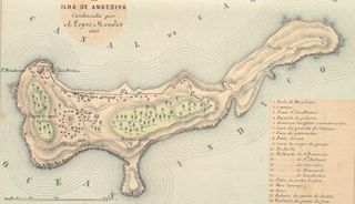
Fort Anjediva, built on the Anjadip Island, off the coast of the Indian state of Karnataka but under the administrative jurisdiction of the Indian state of Goa, was once under Portuguese rule. The island of Anjadip has an area of 1.5 square kilometres (0.58 sq mi).

Fort Tiracol, sometimes known as Terekhol Fort, is a fort in Goa, India. Located on the northern tip of Goa at the mouth of the Tiracol River, Fort Tiracol is reached by a ferry from Querim, 42 km North of Panaji. The name probably originated from the Marathi tir-khol meaning "steep river-bank".
West of India Portuguese Railway (WIPR) was a metre gauge railway from the port of Mormugao via Castle Rock to Londa junction with the Southern Mahratta Railway (SMR).
Portuguese colonial architecture refers to the various styles of architecture that the Portuguese built across the Portuguese Empire. Portuguese colonial Architecture can be found in the plethora of former colonies throughout South America, North Africa, Sub-Saharan Africa, India, Oceania, and East Asia. Many former colonies, especially Brazil, Macau, and India, promote their Portuguese colonial architecture as major tourist attractions.

Churches and convents of Old Goa is the name given by UNESCO to a set of religious monuments located in Goa Velha, in the state of Goa, India, which were declared a World Heritage Site in 1986.

The Fort of São Tiago of Banastarim in India, also known as Fort St. James Banastarim or Benastari Castle, is located at on the right bank of Cumbarjua Canal, on the eastern tip of Old Goa, North Goa district in the state of Goa on the west coast of India.

