
San Luis Obispo County, officially the County of San Luis Obispo, is a county located in the southern region of the U.S. state of California. As of the 2010 census, the population was 269,637. The county seat is San Luis Obispo.

Morro Bay is a waterfront city in San Luis Obispo County, California located along California State Route 1 on California's Central Coast. As of the 2010 census, the city population was 10,234, down from 10,350 at the 2000 census.
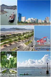
Santos is a municipality in the Brazilian state of São Paulo, founded in 1546 by the Portuguese nobleman Brás Cubas. It is partially located on the island of São Vicente, which harbors both the city of Santos and the city of São Vicente, and partially on the mainland. It is the main city in the metropolitan region of Baixada Santista. The population is 433,966 in an area of 280.67 km2 (108.37 sq mi). The city is also home to the Coffee Museum, where world coffee prices were once negotiated. There is also an association football memorial, dedicated to the city's greatest players, which includes Pelé, who played for the Santos Futebol Clube. Its beachfront garden, 5,335 m (5,834 yd) in length, figures in the Guinness Book of Records as the largest beachfront garden in the world.

The Central Coast is an area of California, United States, roughly spanning the coastal region between Point Mugu and Monterey Bay. It lies northwest of Los Angeles County and south of San Francisco and San Mateo counties. Six counties make up the Central Coast: from south-to north, Ventura, Santa Barbara, San Luis Obispo, Monterey, San Benito, and Santa Cruz.

Oliva is a municipality in the comarca of La Safor in the Valencian Community, Spain. To its east lie 10 kilometres of coastline and beaches fronting the Mediterranean Sea, and eight kilometres to the south is Gandia.

Morro Bay State Park is a state park on the Morro Bay lagoon, in western San Luis Obispo County, central California. On the lagoon’s northeastern and eastern edges in the park, there are saltwater and brackish marshes that support thriving bird populations.

Torres is a city on the coast of south Brazil in the state of Rio Grande do Sul. The city has a population of approximately 40,000 inhabitants, of which 10,000 live in rural zones, but in summer the number of inhabitants reaches 300,000.

Ponta Negra is a famous beach and neighborhood located in the Brazilian city of Natal, the capital of the state of Rio Grande do Norte. Located in the extreme south of the beach is the Morro do Careca, a large dune and an iconic landmark of the city. Located in the extreme north of the beach is the Via Costeira, a long coastal road that connects Ponta Negra with several other beaches of the city, such as Areia Preta and Praia dos Artistas.

Estero Bay is a bay located on the Pacific Coast in San Luis Obispo County, central California. It is about 15 miles (24 km) from its south end at Point Buchon/Montana de Oro State Park, to its north end at Point Estero, which is about 5 miles (8 km) northwest of Cayucos. It is indented about 5 miles (8 km) into the California coast.

Morro de São Paulo is one of 5 villages of the island Tinharé in the municipality of Cairu, located in the state of Bahia, Brazil.

The Dune of Pilat, also called Grande Dune du Pilat) is the tallest sand dune in Europe. It is located in La Teste-de-Buch in the Arcachon Bay area, France, 60 km from Bordeaux.
Santo Antônio do Rio Abaixo is a Brazilian municipality located in the state of Minas Gerais. The city belongs to the mesoregion of Belo Horizonte and to the microregion of Conceição do Mato Dentro. The estimated population in 2010 was 1777 inhabitants.

Genipabu is a beach with a complex of dunes, a lagoon and an environmental protection area (APA) located close to Natal, one of the most famous post-cards of the Rio Grande do Norte Brazilian state.

The Elfin Forest Natural Area is a nature preserve protecting a unique plant community in Los Osos-Baywood Park, San Luis Obispo County, central California. It consists of prehistoric sand dunes, rising 150 feet (46 m) above southern Morro Bay, on the north of Los Osos-Baywood Park.

José de Freitas is a municipality in the state of Piauí in the Northeast region of Brazil.
The South Zone is an area of the city of Rio de Janeiro situated between the Tijuca Massif, the Atlantic Ocean and Guanabara Bay. Most of it is made up of neighbourhoods along the Atlantic coastline, such as São Conrado, Vidigal, Leblon, Ipanema, Copacabana, and Leme.
Careca is a former Brazilian footballer who played as a striker.
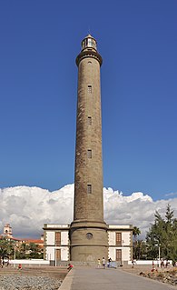
The Maspalomas lighthouse is an active 19th century lighthouse at the southern end of the Spanish island of Gran Canaria, in the Canary archipelago. It lies at one end of the Maspalomas beach, 4 kilometres (2.5 mi) south of the resort town centre, next to the area known as the Maspalomas Dunes.

The Mount of Pai Inácio is a geographic touristic point of Chapada Diamantina National Park. It belongs to city of Palmeiras.


