
North Cornwall is an area of Cornwall, England, United Kingdom. It is also the name of a former local government district, which was administered from Bodmin and Wadebridge 50.516°N 4.835°W. Other towns in the area are Launceston, Bude, Padstow, and Camelford.

St Brides Bay is a bay in western Pembrokeshire, West Wales.

Mount's Bay is a large, sweeping bay on the English Channel coast of Cornwall, United Kingdom, stretching from the Lizard Point to Gwennap Head. In the north of the bay, near Marazion, is St Michael's Mount; the origin of name of the bay. Though it looks to summer visitors like a large, benign, scenic, natural harbour, in an onshore winter gale it presents a great danger to shipping and a "maritime trap", especially for sailing ships. There are more than 150 known wrecks from the nineteenth century in the area. The eastern side of the bay centred around Marazion and St Michael's Mount was designated as a Marine Conservation Zone in January 2016.
Trebetherick is a village on the north coast of Cornwall. It is situated on the east side of the River Camel estuary approximately six miles (10 km) north of Wadebridge and half a mile south of Polzeath.

Poole Bay is a bay in the English Channel, on the coast of Dorset in southern England, which stretches 16 km from Sandbanks at the mouth of Poole Harbour in the west, to Hengistbury Head in the east. Poole Bay is a relatively shallow embayment and consists of steep sandstone cliffs and several 'chines' that allow easy access to the sandy beaches below. The coast along the bay is continuously built up, and is part of the South East Dorset conurbation, including parts of the towns of Poole, Bournemouth and Christchurch. The bay is often erroneously referred to as Bournemouth Bay, because much of it is occupied by Bournemouth.
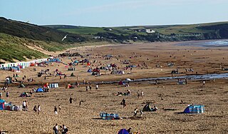
Woolacombe is a seaside resort on the coast of North Devon, England, which lies at the mouth of a valley in the parish of Mortehoe. The beach is 3 miles (4.8 km) long, sandy, gently sloping and faces the Atlantic Ocean near the western limit of the Bristol Channel.

Mortehoe is a village and former manor on the north coast of Devon, England. It lies 10 miles north-west of Barnstaple, near Woolacombe and Lee Bay, and is sited in a valley within the hilly sand-dune-like land behind Morte Point. The parish population at the 2011 census was 1,637.

Lee Bay or just Lee is a small village on the North Devon coast near Woolacombe. Lee is situated on the rugged and inhospitable stretch of coast between Ilfracombe and Woolacombe, which includes Bull Point and Morte Point, both notorious for shipwrecks in earlier times, and both on the South West Coast Path.

Carboniferous Limestone is a collective term for the succession of limestones occurring widely throughout Great Britain and Ireland that were deposited during the Dinantian Epoch of the Carboniferous Period. These rocks formed between 363 and 325 million years ago. Within England and Wales, the entire limestone succession, which includes subordinate mudstones and some thin sandstones, is known as the Carboniferous Limestone Supergroup.

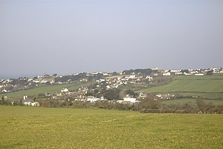
Putsborough is a hamlet in Georgeham civil parish on the west-facing coast of North Devon, England. It is about 3⁄4 mile (1.2 km) north of the village of Croyde and 1 mile (1.6 km) WNW of the village of Georgeham. 0.5 miles (0.8 km)North of the hamlet is Putsborough Sand, which forms the southern part of the two-mile-long (3 km) beach of Woolacombe Sand on Morte Bay.
The North Devon Coast was designated as an Area of Outstanding Natural Beauty in September 1959. The AONB contributes to a family of protected landscapes in the Southwest of England and a total of 38% of the region is classified by the International Union for the Conservation of Nature as Category V Protected Landscapes. The twelve Areas of Outstanding Natural Beauty extend to 30% of the region, twice the proportion covered by AONBs in England as a whole and a further two National Parks, Dartmoor and Exmoor, cover an addition 7%. The North Devon Coast AONB covers 171 square kilometres (66 sq mi) of mainly coastal landscape from the border of Exmoor National Park at Combe Martin, through the mouth of the Taw & Torridge Estuary to the Cornish border at Marsland Mouth. The dune system at Braunton Burrows forms the core area of North Devon's Biosphere Reserve, the first "new style" Unesco-designated reserve in the United Kingdom. The whole of the AONB is within the Reserve boundaries.
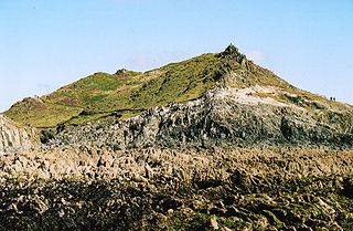
Morte Point is a peninsula on the north west coast of Devon, England, belonging to the National Trust. To the east is the village of Mortehoe and to the south is the seaside resort of Woolacombe.

The Bay of Isles is a bay 9 miles (14 km) wide and receding 3 miles (5 km), lying between Cape Buller and Cape Wilson along the north coast of South Georgia. It was discovered in 1775 by a British expedition under James Cook and so named by him because numerous islands lie in the bay. Of South Georgia's 31 breeding bird species, 17 are found here.

Bull Point Lighthouse is a lighthouse on Bull Point, about one mile (1.6 km) north of the village of Mortehoe, on the northern coast of Devon, England. The lighthouse provides a visual aid to the villages of Mortehoe, Woolacombe and Ilfracombe, and warns of the inhospitable and rocky coast that lines the area.
Bideford Bay, also known as Barnstaple Bay and often shown on maps as Barnstaple or Bideford Bay, is a large area of water on the northwest coast of Devon in South West England, at the southwestern end of the Bristol Channel where it joins the Celtic Sea. The bay extends from Hartland Point in the southwest to Morte Point in the northeast, a distance of 14 miles (23 km), and is partly sheltered by the island of Lundy, 12 miles (19 km) offshore. It takes its alternative names from the towns of Bideford and Barnstaple, located respectively on the rivers Torridge and Taw which flow into the bay. The alternative spelling Barnstable Bay, in use long after that spelling became obsolete for the town, is also sometimes seen.
The geology of Tyne and Wear in northeast England largely consists of a suite of sedimentary rocks dating from the Carboniferous and Permian periods into which were intruded igneous dykes during the later Palaeogene Period.

The Exmoor Group is a late Devonian to early Carboniferous lithostratigraphic group in southwest England whose outcrop extends from Croyde in north Devon east across Exmoor to Minehead in west Somerset. The group comprises the following formations the:
The geology of Northumberland in northeast England includes a mix of sedimentary, intrusive and extrusive igneous rocks from the Palaeozoic and Cenozoic eras. Devonian age volcanic rocks and a granite pluton form the Cheviot massif. The geology of the rest of the county is characterised largely by a thick sequence of sedimentary rocks of Carboniferous age. These are intruded by both Permian and Palaeogene dykes and sills and the whole is overlain by unconsolidated sediments from the last ice age and the post-glacial period. The Whin Sill makes a significant impact on Northumberland's character and the former working of the Northumberland Coalfield significantly influenced the development of the county's economy. The county's geology contributes to a series of significant landscape features around which the Northumberland National Park was designated.

Budle Bay is a 1 mile (1.6 km) wide bay on the North Sea in Northumberland, England, between Bamburgh to the southeast and Lindisfarne to the northwest.
Pickwell is a small settlement with a converted manor house in the parish of Georgeham in North Devon, England.


