
Kent County is located in east-central New Brunswick, Canada. The county features a unique blend of cultures including Mi'kmaq, Acadian, and English. Some larger tourist attractions include the dune de Bouctouche, Kouchibouguac National Park, and Bonar Law Commons.

Westmorland County is a county in New Brunswick, a province of Canada. It is in the south-eastern part of the province. It contains the fast-growing commercial centre of Moncton and its northern and eastern suburbs. Also located in the county are the university town of Sackville and the tourist destination Shediac.

Dundas is a civil parish in Kent County, New Brunswick, Canada.
Sainte-Marie-de-Kent is an unincorporated Canadian village located at the intersection of Route 515 and Route 525 in Kent County, New Brunswick. It is in the parish of Saint Mary.

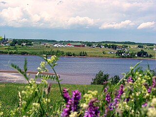
Cocagne is a Canadian community, formerly part of an eponymous local service district (LSD) and later incorporated rural community, in Kent County, New Brunswick. It is now part of the rural community of Beausoleil.

State Route 161 (SR 161) is part of Maine's system of numbered state highways. It runs 86 miles (138 km) from Fort Fairfield to Allagash. It begins at the Fort Fairfield - Andover Border Crossing along the Canada–US border to Dickey Road near the confluence of the Allagash and Saint John rivers.
Route 134 is a 261 km (162 mi)-long north–south secondary highway in eastern New Brunswick, Canada. The highway is divided by into a northern and southern section by a gap in Northumberland County connected by Route 11 and Route 8.
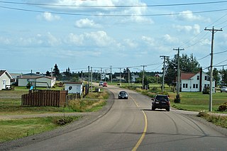
Caissie Cape French: Cap-des-Caissie, is a small coastal community in Dundas Parish, Kent County, New Brunswick. Bordered on the north by Cocagne Cape, to the east by Cocagne Cove, and to the south by Bourgeois, Caissie Cape comprises New Brunswick Route 530, Chemin De La Cote and the roads that run between them. The community mostly consists of cottages owned by residents of New Brunswick, especially Moncton, though year-round homes do exist. Those who do live in Caissie Cape year round are primarily Acadians. Many of the streets are privately owned, as is common with other cottage communities in the area such as Grande-Digue and Shediac Bridge-Shediac River.
Route 126 is a North/South provincial highway in the Canadian province of New Brunswick. The road runs from Route 117 intersection in Miramichi. The road has a length of approximately 121 kilometres, and services small, otherwise isolated rural communities. In these areas, the highway is often unofficially referred to as "Main Street." The road parallels the New Brunswick East Coast Railway directly to the east. When the highway enters Moncton it changes to Ensley Drive, then Mountain Road.

Bass River is a small farming and forestry community located in Weldford Parish, New Brunswick that developed around the Bass River, a fresh water tributary of the Richibucto River. Bass River is located between the Intersection of Route 116 and Route 490.
Hebert is a Canadian community, located in Kent County, New Brunswick. The community is situated in southeastern New Brunswick, to the northwest of Moncton. Hebert is located mainly at the intersection of New Brunswick Route 126 and New Brunswick Route 515. The end of the Bouctouche River ends north of this community.
Harcourt is a Canadian unincorporated community, located in Kent County, New Brunswick. The community is situated in southeastern New Brunswick, Between Moncton and Nouvelle-Arcadie. Population, according to Statistics Canada Census 2011, is 390. Average age of population is 50. Harcourt is located around the intersection of Route 116 and Route 126.
Kent Junction is a Canadian unincorporated community, located in Kent County, New Brunswick. The community is situated in southeastern New Brunswick, between Moncton and Nouvelle-Arcadie. Kent Junction is located mainly on New Brunswick Route 126.
Route 475 is a 21-kilometre (13 mi) long west–east secondary highway in the northwest portion of New Brunswick, Canada.
Route 495 is a 23-kilometre (14 mi) long north–south secondary highway in the northwest portion of New Brunswick, Canada.

Route 505 is a 45-kilometre (28 mi) long north–south secondary highway in the northwest portion of New Brunswick, Canada.
Route 515 is a 38-kilometre (24 mi) long east–west secondary highway in the south east portion of New Brunswick, Canada.
Route 525 is a 10-kilometre (6.2 mi) long east–west secondary highway in the northwest portion of New Brunswick, Canada.
Route 535 is a 30-kilometre (19 mi) long north-east looping secondary highway in the south east portion of New Brunswick, Canada.
Route 565 is a 19.7-kilometre (12.2 mi) long north–south looping secondary highway in the western portion of New Brunswick, Canada.