Mosterøy (island)

Last updated
Mosterøy
Mosterøya
Rennesoy og Mosteroy, Rogaland.JPG
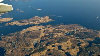
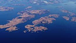
View of Rennesøy (left, center)
and Mosterøy (right, center)
Norway Rogaland location map.svg
Red pog.svg
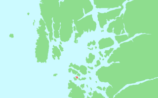
Mosterøy
Mosterøya
Location in Rogaland county
Geography
Location Rogaland, Norway
Coordinates 59°05′07″N5°38′12″E / 59.0853°N 5.6367°E / 59.0853; 5.6367 Coordinates: 59°05′07″N5°38′12″E / 59.0853°N 5.6367°E / 59.0853; 5.6367
Area12 km2 (4.6 sq mi)
Highest elevation154 m (505 ft)
Highest pointMastravarden
Administration
County Rogaland
Municipality Rennesøy
Demographics
Population1,069 [1] (2017)
Pop. density89 /km2 (231 /sq mi)

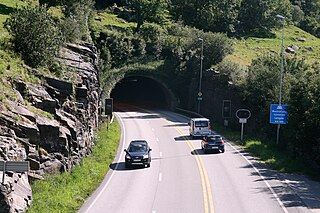
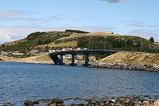
Mosterøy or Mosterøya is an island in Rennesøy municipality in Rogaland county, Norway. The 12-square-kilometre (4.6 sq mi) island lies just southwest of the island of Rennesøy. The smaller islands of Sokn, Bru, and Åmøy lie to the south of Mosterøy and the islands of Klosterøy and Fjøløy lie to the west of Mosterøy. All of these islands are connected together and to the mainland city of Stavanger by a series of undersea tunnels and bridges. The Mastrafjord Tunnel connects Mosterøy to the island of Rennesøy and the Askjesund Bridge connects Mosterøy to the island of Sokn. Both the tunnel and bridge are part of the European route E39 highway. [2]

Island Any piece of sub-continental land that is surrounded by water

An island or isle is any piece of sub-continental land that is surrounded by water. Very small islands such as emergent land features on atolls can be called islets, skerries, cays or keys. An island in a river or a lake island may be called an eyot or ait, and a small island off the coast may be called a holm. A grouping of geographically or geologically related islands is called an archipelago, such as the Philippines.

Rennesøy Municipality in Rogaland, Norway

Rennesøy is an island municipality in Rogaland county, Norway. It is located in the traditional district of Ryfylke. The administrative centre of the municipality is the village of Vikevåg. Other villages in Rennesøy include Askje and Sørbø. The municipality encompasses a number of islands on the south side of the Boknafjorden, north of the city of Stavanger.

Rogaland County (fylke) of Norway

Rogaland[²ruːɡɑlɑn](listen) is a county in Western Norway, bordering Hordaland, Telemark, Aust-Agder, and Vest-Agder counties. Rogaland is the center of the Norwegian petroleum industry. In 2016, Rogaland had an unemployment rate of 4.9%, one of the highest in Norway. In 2015, Rogaland had a fertility rate of 1.78 children per woman, which is the highest in the country.

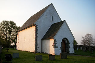
The island of Mosterøy has been part of Rennesøy municipality for a long time, but in 1884 it became a part of the new municipality of Mosterøy which encompassed the island plus several surrounding islands. This independent municipality existed until 1965 when it was merged back into Rennesøy municipality.

Mosterøy Former Municipality in Western Norway, Norway

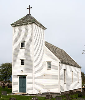
Mosterøy is a former municipality in Rogaland county, Norway. The administrative centre was the village of Askje where the Askje Church is located. The 23-square-kilometre (8.9 sq mi) municipality existed from 1884 until 1965. The island municipality included the islands of Mosterøy, Klosterøy, Fjøløy, Sokn, Bru, and the western half of Åmøy. Today, Mosterøy is part of the municipality of Rennesøy.

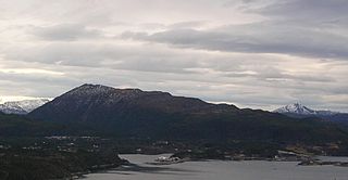
Mosterøy is a well-cultivated island, with significant livestock and horticulture. The highest point is the 154-metre (505 ft) tall mountain Mastravarden, located on the west side of Mosterøy. There are residential areas all over the island, but especially in the east. [2]

Livestock Domesticated animals

Livestock is commonly defined as domesticated animals raised in an agricultural setting to produce labor and commodities such as meat, eggs, milk, fur, leather, and wool. The term is sometimes used to refer solely to those that are bred for consumption, while other times it refers only to farmed ruminants, such as cattle and goats. Horses are considered livestock in the United States. The USDA uses livestock similarly to some uses of the term “red meat”, in which it specifically refers to all the mammal animals kept in this setting to be used as commodities. The USDA mentions pork, veal, beef, and lamb are all classified as livestock and all livestock is considered to be red meats. Poultry and fish are not included in the category.

Horticulture branch of agriculture involving plants

Horticulture has been defined as the culture of plants for food, comfort and beauty. A more precise definition can be given as "The cultivation, processing, and sale of fruits, nuts, vegetables, ornamental plants, and flowers as well as many additional services". It also includes plant conservation, landscape restoration, soil management, landscape and garden design, construction, and maintenance, and arboriculture. In contrast to agriculture, horticulture does not include large-scale crop production or animal husbandry.

See also

Related Research Articles

Bokn Municipality in Rogaland, Norway

Bokn is a municipality in Rogaland county, Norway. It is located in the traditional district of Haugaland. The administrative centre of the municipality is the village of Føresvik, the only urban area in Bokn. Other villages in Bokn include Arsvågen, Trosnavåg, and Loten. The island municipality is mostly located on the three islands of Ognøya, Vestre Bokn, and Austre Bokn. All three main islands are connected to the mainland via a network of bridges.

Finnøy Municipality in Rogaland, Norway

Finnøy is an island municipality in Rogaland county, Norway. It is located in the traditional district of Ryfylke. The administrative centre of the municipality is the village of Judaberg.

Gjemnes Municipality in Møre og Romsdal, Norway

Gjemnes is a municipality in Møre og Romsdal county, Norway on the Romsdal peninsula. It is part of the Nordmøre region. The administrative centre is the village of Batnfjordsøra, which lies along the Batnfjorden and it is a former steamship landing place. Other villages in Gjemnes include Torvikbukt, Flemma, Angvika, Gjemnes, Øre, and Osmarka.

Boknafjord human settlement

Boknafjord or Boknafjorden is a fjord located in Rogaland county, Norway. The huge fjord lies between the cities Stavanger and Haugesund, and the main part of the fjord is shared between the municipalities of Kvitsøy, Rennesøy, Finnøy, Tysvær, Bokn, and Karmøy. There are dozens of smaller fjords that branch off the main part of the fjord, reaching most municipalities in the county. At its longest, the Boknafjord reaches about 96 kilometres (60 mi) into the mainland at the innermost point of the Hylsfjorden. Other notable branches include the Saudafjorden, Sandsfjorden, Vindafjorden, Hervikfjorden, Førresfjorden, Erfjorden, Jøsenfjorden, Årdalsfjorden, Idsefjorden, Høgsfjorden, Lysefjorden, and Gandsfjorden.

Talgje

Talgje is a populated island in southwestern Finnøy municipality in Rogaland county, Norway. The 4.1-square-kilometre (1.6 sq mi) island is located in the Talgjefjorden and Brimsefjorden, both arms off of the main Boknafjorden in a large archipelago of islands northeast of the city of Stavanger. It is surrounded by islands: Brimse to the south, Rennesøy to the west, Finnøy to the north, and Fogn to the northeast. The island has a lot of agricultural uses, especially in growing tomatoes.

The Finnøy Tunnel or Finnøy Fixed Link is an undersea road tunnel in Rogaland county, Norway. It connects the island of Finnøy to the nearby island of Rennesøy, and ultimately to the mainland. The main tunnel is 5,685 metres (3.53 mi) long and it also includes a 1,467-metre (0.91 mi) long arm, which connects the tunnel to the island of Talgje.

Vestre Bokn isle in Norway

Vestre Bokn is an island in Bokn municipality in Rogaland county, Norway. The 36-square-kilometre (14 sq mi) island is the main island of the municipality. It lies on the northern side of the Boknafjorden at the southern end of the Karmsundet strait. Vestre Bokn lies between the islands of Karmøy and Austre Bokn and Ognøya. The main population centre on the island is the village of Føresvik, the administrative centre of the whole municipality. There are about 661 inhabitants on the island.

Byfjord Tunnel road tunnel

The Byfjord Tunnel is a subsea road tunnel in Rogaland county, Norway. The 5,875-metre (19,275 ft) long tunnel runs between Grødem on the mainland in Randaberg and the island of Sokn in Rennesøy municipality, running underneath the Byfjorden. The tunnel was built as part of the Rennesøy Fixed Link project which opened in 1992 with the goal of connecting all the islands of Rennesøy to the mainland. The tunnel was a toll road from 1992 until 2006. The tunnel is part of European route E39 highway. With a maximum 8% grade, the tunnel reaches a depth of 223 metres (732 ft) below sea level at its lowest point. The tunnel held the distinction of being Europe's longest and the world's deepest tunnel upon its completion, it was surpassed by a deeper tunnel in 1994 and a longer tunnel in 1999. The tunnel had an average daily traffic of 9,717 vehicles in 2018.

Mastrafjord Tunnel

The Mastrafjord Tunnel is a subsea road tunnel in Rennesøy municipality in Rogaland county, Norway. The 4,424-metre (2.75 mi) long tunnel runs under the Mastrafjorden, which flows between the islands of Mosterøy and Rennesøy. The tunnel opened in 1992 as part of the European route E39 highway and the Rennesøy Fixed Link. The southern end of the tunnel is located near the village of Askje on Mosterøy and the northern end of the tunnel is in the village of Vikevåg on Rennesøy. With a maximum grade of 8%, the tunnel reaches its deepest point at 133 metres (436 ft) below sea level.

Sokn island in Rennesøy, Norway

Sokn is an island in Rennesøy municipality in Rogaland county, Norway. The 1.31-square-kilometre (0.51 sq mi) island lies in a group of islands on the south side of the Boknafjorden, just east of the city of Stavanger. There are several islands surrounding Sokn: Bru to the southwest, Åmøy to the southeast, and Mosterøy to the north. All three islands are connected to Sokn by bridges, and the undersea Byfjord Tunnel has its northern terminus on the island, connecting all these islands to the mainland.

Bru, Rogaland island in Rennesøy, Norway

Bru is an island in Rennesøy municipality in Rogaland county, Norway. The 3-square-kilometre (1.2 sq mi) island lies south of the Boknafjorden, just off the coast of the Stavanger peninsula, along the Byfjorden. The highest point on the island is the 92-metre (302 ft) tall mountain, Brufjellet. The island sits in a group of islands with Sokn and Mosterøy to the north and Åmøy to the east.

Frei (island) island in Kristiansund Municipality in Møre og Romsdal county, Norway

Frei is an island in Kristiansund Municipality in Møre og Romsdal county, Norway. The 62.5-square-kilometre (24.1 sq mi) island lies south of the town of Kristiansund in the Nordmøre region of the county. The main villages on the island include Rensvik in the north, Kvalvåg in the east, and Nedre Frei in the south. The island was part of the old Frei Municipality from 1838 until 2008 when the island was merged into Kristiansund Municipality.

Åmøy island in Stavanger, Norway

Åmøy is an island that is divided between Rennesøy and Stavanger municipalities in Rogaland county, Norway. The 5.3-square-kilometre (2.0 sq mi) island lies just north of the city of Stavanger in a group of islands. The islands of Sokn and Bru both lie to the west of Åmøy and the islands of Mosterøy and Rennesøy lie to the north, and the island of Hidle lies to the east.

Rennesøy (island) island in Norway

Rennesøy is an island in Rennesøy municipality in Rogaland county, Norway. The 40.7-square-kilometre (15.7 sq mi) island lies on the south side of the Boknafjorden, surrounded by several other islands. The islands of Mosterøy, Klosterøy, and Åmøy lie to the south and Finnøy and Talgje lie to the northeast. The villages of Vikevåg and Sørbø are both located on the island. Vikevåg is the administrative centre of the municipality. The Hausken Church is located in Vikevåg and the 900-year old Sørbø Church is located in Sørbø.

Klosterøy island in Rennesøy, Norway

Klosterøy is an island in Rennesøy municipality in Rogaland county, Norway. The 1.7-square-kilometre (0.66 sq mi) island lies on the south side of the Boknafjorden in the Rennesøy island group. It lies immediately north of the island of Fjøløy and immediately west of the island of Mosterøy. All three islands are connected by bridges and Mosterøy is connected to the island of Sokn which in turn is connected to the mainland by the Byfjord Tunnel.

Fjøløy

Fjøløy is an island in Rennesøy municipality in Rogaland county, Norway. The 2.1-square-kilometre (0.81 sq mi) island lies on the south side of the Boknafjorden in the Rennesøy island group. The island lies immediately south of the island of Klosterøy and west of the island of Mosterøy. The island is connected to the mainland by a series of bridges and tunnels. The Fjøløy Lighthouse is located on the western end of the island.

Vestre Åmøy Chapel Church in Rogaland, Norway

Vestre Åmøy Chapel is a chapel in Rennesøy municipality in Rogaland county, Norway. It is located on the western end of the island of Åmøy. The chapel is part of the Mosterøy parish in the Tungenes deanery in the Diocese of Stavanger. The white, wooden chapel was built in 1953 and renovated in 1980. The chapel seats about 80 people.

Askje Church Church in Rogaland, Norway

Askje Church is a parish church in Rennesøy municipality in Rogaland county, Norway. It is located in the village of Askje on the island of Mosterøy. The church is part of the Mosterøy parish in the Tungenes deanery in the Diocese of Stavanger. The white, wooden church was built in 1846 using designs by the architect Hans Linstow. The church seats about 250 people.

References

  1. https://snl.no/Mosterøy_-_øy
  2. 1 2 Store norske leksikon. "Mosterøy – øy" (in Norwegian). Retrieved 2015-12-09.