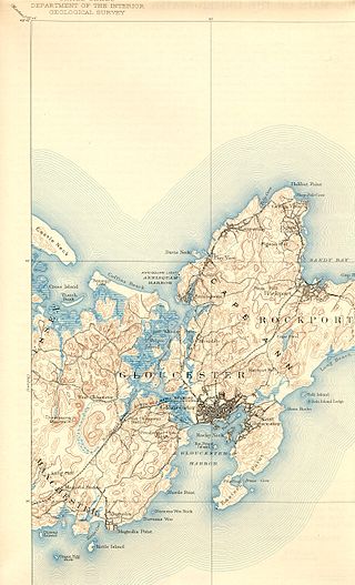
Gloucester is a city in Essex County, Massachusetts, United States. It sits on Cape Ann and is a part of Massachusetts's North Shore. The population was 29,729 at the 2020 U.S. Census. An important center of the fishing industry and a popular summer destination, Gloucester consists of an urban core on the north side of the harbor and the outlying neighborhoods of Annisquam, Bay View, Lanesville, Folly Cove, Magnolia, Riverdale, East Gloucester, and West Gloucester.

Ocean Bluff-Brant Rock is a census-designated place (CDP) in Plymouth County, Massachusetts, United States, composed of the neighborhoods of Ocean Bluff, Brant Rock, Fieldston, and Rexhame in the town of Marshfield. The population of the CDP was 4,970 at the 2010 census.
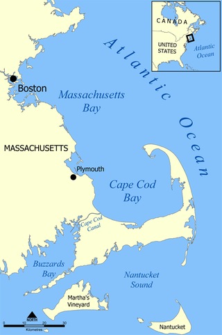
Massachusetts Bay is a bay on the Gulf of Maine that forms part of the central coastline of the Commonwealth of Massachusetts.

Marblehead is a coastal New England town in Essex County, Massachusetts, United States, along the North Shore. Its population was 20,441 at the 2020 census. The town lies on a small peninsula that extends into the northern part of Massachusetts Bay. Attached to the town is a near island, known as Marblehead Neck, connected to the mainland by a narrow isthmus. Marblehead Harbor, protected by shallow shoals and rocks from the open sea, lies between the mainland and the Neck. Beside the Marblehead town center, two other villages lie within the town: the Old Town, which was the original town center, and Clifton, which lies along the border with the neighboring town of Swampscott.

Cape Ann is a rocky peninsula in northeastern Massachusetts on the Atlantic Ocean. It is about 30 miles (48 km) northeast of Boston and marks the northern limit of Massachusetts Bay. Cape Ann includes the city of Gloucester and the towns of Essex, Manchester-by-the-Sea and Rockport.
Annisquam is a waterfront village in the city of Gloucester in Essex County on the North Shore of Massachusetts, United States. It is a few miles across Cape Ann from downtown Gloucester.

Lovecraft Country is a term coined for the New England setting used by H. P. Lovecraft in many of his weird fiction stories, which combines real and fictitious locations. This setting has been elaborated on by other writers working in the Cthulhu Mythos. The phrase was not in use during Lovecraft's own lifetime; it was coined by Keith Herber for the Lovecraftian role-playing game Call of Cthulhu.

Ravenswood Park is a nature reserve in the western section of Gloucester, Massachusetts owned and managed by the Trustees of Reservations, which acquired the property in 1993. It can be accessed from Western Avenue, the road to Manchester through the Magnolia area. Ravenswood Park is frequented by cross-country skiers during the winter.

Route 127 is a 26.70-mile-long (42.97 km) north–south Massachusetts state route that runs from Beverly to Gloucester. Much of the northern part of the route is in Cape Ann. Route 127's southern terminus is at Route 1A and the southern terminus of Route 22 in Beverly and the northern terminus is at Route 128 in Gloucester.

"The Strange High House in the Mist" is a short story by H. P. Lovecraft. Written on November 9, 1926, it was first published in the October 1931 issue of Weird Tales. It concerns a character traveling to the titular house which is perched on the top of a cliff which seems inaccessible both by land and sea, yet is apparently inhabited.
The Annisquam River is a tidal, salt-water estuary in the Annisquam neighborhood of Gloucester, Massachusetts, connecting Annisquam Harbor on the north to Gloucester Harbor on the south. The segment between Gloucester Harbor and the Newburyport/Rockport Line bridge is also known as the Blynman Canal.

Crowninshield Island, also known as Brown's Island, is a small island off the shore of Marblehead, Massachusetts. Since 1955, it has been maintained by The Trustees of Reservations. For all Trustees of Reservations purposes, the island is referred to as Crowninshield Island, however federally the island is still maintained as "Brown's Island", and it remains better known by that name locally.

Quincy Point is a neighborhood of Quincy, Massachusetts. "The Point" is generally defined as the land east of Quincy Center, the downtown district. Quincy Point is bordered on the west by Elm Street, on the east by Weymouth Fore River and the Braintree city line, on the north by Town River and on the south by Quincy Avenue. The area altitude averages about 30 feet (9.1 m) above sea level. The population of this neighborhood in 2000 was 11,414.

Eastern Point Light is a historic lighthouse on Cape Ann, in northeastern Massachusetts. It is known as the oldest seaport in America. The harbor has supported fishermen, whalers, and traders since 1616.

The Misery Islands are an 87-acre (350,000 m2) nature reserve established in 1935 in Salem Sound close to the Salem Harbor in Salem, Massachusetts. It is managed by the Trustees of Reservations. The islands are a part of the city of Salem, although they are much closer to the mainland of the city of Beverly, in whose aquatic territory they lie.

Thacher Island is a small island off Cape Ann on the Massachusetts coast in the United States. It is a part of the Town of Rockport. It was a place where some naval confrontations, both minor and major, took place, which helped secure a victory for the colonists.

Norman's Woe is a rock reef on Cape Ann in Gloucester, Massachusetts, about 500 feet offshore.

Stage Fort Park is a park at Stage Head in Gloucester, Massachusetts, part of the Essex National Heritage Area. It contains two beaches, a large playground, picnic benches, two baseball fields, a basketball court, a dog park and plenty of room for any weekend activities. The park includes Gloucester's Visitor and Welcome Center and Stage Fort, a reconstructed Civil War fort on a site fortified since 1635.
Great House in Cape Ann was a seventeenth century structure built by colonists in present-day Gloucester, Massachusetts. It was later disassembled and moved to Salem, Massachusetts, to be the Governor's house.
Eastern Point Fort was a fort that was garrisoned or maintained from 1863 to 1867 on Eastern Point in Gloucester, Massachusetts, built for the American Civil War. References indicate the name has also been used to refer to the much-older Stage Fort across the harbor.

