The Cook Islands can be divided into two groups: the Southern Cook Islands and the Northern Cook Islands. The country is located in Oceania, in the South Pacific Ocean, about halfway between Hawaii and New Zealand.

Aitutaki, also traditionally known as Araʻura and Utataki, is the second most-populated island in the Cook Islands, after Rarotonga. It is an "almost atoll", with fifteen islets in a lagoon adjacent to the main island. Total land area is 18.05 km2 (6.97 sq mi), and the lagoon has an area of between 50 and 74 km2. A major tourist destination, Aitutaki is the second most visited island of the Cook Islands archipelago.

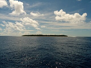
Pukapuka, formerly Danger Island, is an inhabited coral atoll in the northern group of the Cook Islands in the Pacific Ocean. It is one of the most remote islands of the Cook Islands, situated about 1,140 kilometres northwest of Rarotonga. On this small island, an ancient culture and distinct language have been maintained over many centuries. The traditional name for the atoll is Te Ulu-o-Te-Watu, and the northern islet where the people normally reside is affectionately known as Wale ('Home').
Pukapukan is a Polynesian language that developed in isolation on the island of Pukapuka in the northern group of the Cook Islands. As a "Samoic Outlier" language with strong links to western Polynesia, Pukapukan is not closely related to any other languages of the Cook Islands, but does manifest substantial borrowing from some East Polynesian source in antiquity.
Nassau is an island in the northern group of the Cook Islands. It is approximately 1,246 kilometres (774 mi) north of the capital island of Rarotonga and 88 kilometres (55 mi) from Pukapuka coral atoll. Lacking an airstrip, it is accessible only by boat. It is named after a 19th-century whaling ship. Its indigenous name, Te Nuku-o-Ngalewu, means "Land of Ngalewu" after the Pukapukan who was put in charge of it.

Manihiki is an atoll in the northern group of the Cook Islands known informally as the "Island of Pearls". It is located in the Northern Cook Island chain, approximately 1,299 kilometres (807 mi) north of the capital island of Rarotonga, making it one of the most remote inhabitations in the Pacific Ocean. Its name has two possible meanings: It is believed that the original name of the island was Manuhiki, inspired by the aboriginal discoverers, Manu coming from the word Rua Manu and Hiki meaning ashore, so the literal translation would be canoe carried ashore. The second interpretation is that the original discoverers were from Manihi, an island in Tuamotus, so the name of the island would mean Little Manihi.
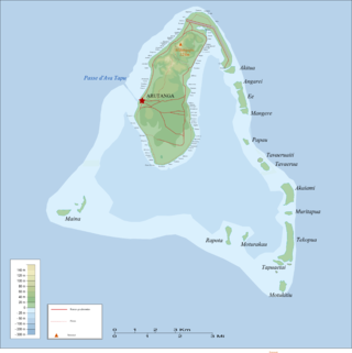
Ee (island) is one of 22 islands in the Aitutaki atoll of the Cook Islands. Located between the smaller islands of Angarei and Mangere, it is the third largest of the Aitutaki motus, after Tekopua and Akaiami, and measures 975m long and up to 410m wide.
Motukitiu is one of 22 islands in the Aitutaki atoll of the Cook Islands. It is a small island located at the southeastern tip of Aitutaki Lagoon, one kilometre to the south of the larger island of Tekopua and eight kilometres to the southeast of the main island of Aitutaki. The island is 450m long and 300m wide.
Akaiami is one of 22 islands in the Aitutaki atoll of the Cook Islands. It is located on the eastern perimeter of Aitutaki Lagoon to the north of the smaller islands of Muritapua, five kilometres to the southeast of the main island of Aitutaki. It is the second-largest of the Aitutaki motus, after Tekopua, measuring 1120m long and 410m wide. During the 1950s the island was used as a stopover for TEAL flying boats on the famous Coral Route. These operations ceased in 1960, and the only reminder are the remains of the purpose-built jetty.
Tema Reef, also called Tima Reef, is a submerged coral reef in the northern island group of the Cook Islands, 23 kilometres southeast of Pukapuka coral atoll.

The Northern Cook Islands is one of the two chains of atolls which make up the Cook Islands. Lying in a horizontal band between 9° and 13°30' south of the Equator, the chain consists of the atolls of Manihiki, Nassau, Penrhyn, Pukapuka, Rakahanga and Suwarrow, along with the submerged Tema Reef.

Severe Tropical Cyclone Martin was the deadliest tropical cyclone of the 1997–98 South Pacific cyclone season. The system was first noted as a weak tropical disturbance on October 27, to the north of the Northern Cook Islands. Over the next few days atmospheric convection surrounding the system remained disorganized, as it moved towards the southwest and was affected by strong upper-level north-easterly winds and moderate to strong vertical wind shear. The system was subsequently named Martin during October 31, after it had rapidly developed further and shown a marked improvement organization.

Renewable energy in the Cook Islands is primarily provided by solar energy and biomass. Since 2011 the Cook Islands has embarked on a programme of renewable energy development to improve its energy security and reduce greenhouse gas emissions, with an initial goal of reaching 50% renewable electricity by 2015, and 100% by 2020. The programme has been assisted by the governments of Japan, Australia, and New Zealand, and the Asian Development Bank.

Florence Ngatokura "Johnny" Frisbie, also known as Johnny Frisbie Hebenstreit, is a Cook Islands author. Her autobiographical children's novel, Miss Ulysses of Puka-Puka (1948), was the first published literary work by a Pacific Islander woman author.
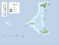
Motu Kō is one of three islands in the Pukapuka atoll of the Cook Islands. It forms the southern apex of Pukapuka's triangular atoll, 10km south of Wale, and is the largest of the three islands. The island is low-lying, with a maximum elevation of 5 meters above sea level and most of it only one or two meters. Motu Kō is uninhabited and used as a food source, and is regulated by the village of Ngake.
Wale ("house") is one of three islands in the Pukapuka atoll of the Cook Islands. It forms the northern apex of Pukapuka's triangular atoll, and is the only permanently inhabited island. The island is low-lying, with a maximum elevation of 4 meters above sea level. The three villages of Yato, Loto, and Ngake are located on the island, and regulate the other two islands as food sources.
Yato is one of three villages on the island of Wale in the Pukapuka atoll of the Cook Islands. Yato is the westernmost village and regulates the island of Motu Kotawa and the sand cay of Toka.
Toka is a sand cay in the Pukapuka atoll of the Cook Islands. The cay is to the west of the atoll, separated from the island of Motu Kotawa by a reef. It is regulated by the village of Yato, and is extremely dangerous to land on.
Ngake is one of three villages on the island of Wale in the Pukapuka atoll of the Cook Islands. It is the easternmost village and regulates the island of Motu Kō.
Loto is one of three villages on the island of Wale in the Pukapuka atoll of the Cook Islands. It is the central village and regulates Motu Uta, the major food-production area on Wale.