Mofmanu Beach, the popular main beach adjacent to the village of Motusa
Motusa is a group of close villages in the district of Itu'tiu, on the island of Rotuma, one of the islands of Fiji. Rotuma is made up of two volcanic landmasses connected by a sandy isthmus, on which Motusa is located. For this reason it has one of the islands longest white sandy beach. Motusa also sits between the Islands two largest bay; Maka Bay to the North and Hapmafau Bay to the South.
Motusa also has a primary school known as Motusa District School, that consist of Year 1 to Year 8. Motusa is about one kilometer southwest of Ahau, the government station, which is also the location of the island's post office, and a small hospital. Ahau is now the administrative center of Rotuma, although for a long time Motusa, being the largest settlement, and one of the best moorings, was the centre of most business transactions and industry.
Basseterre is the capital and largest city of Saint Kitts and Nevis with an estimated population of 14,000 in 2018. Geographically, the Basseterre port is located at 17°18′N62°44′W, on the south western coast of Saint Kitts Island, and it is one of the chief commercial depots of the Leeward Islands. The city lies within Saint George Basseterre Parish.
Dartmouth is a coastal town in Bristol County, Massachusetts. Old Dartmouth was the first area of Southeastern Massachusetts to be settled by Europeans, primarily English. Dartmouth is part of New England's farm coast, which consists of a chain of historic coastal villages, vineyards, and farms. June 8, 2014 marked the 350th year of Dartmouth's incorporation as a town. It is also part of the Massachusetts South Coast. The local weekly newspapers are The Dartmouth/Westport Chronicle and Dartmouth Week.
Saltaire is a village on Fire Island in the southern part of the Town of Islip in Suffolk County, New York, United States. The year-round population was 37 at the 2010 census, which, as a summer beach community, increases many times over in the summer.
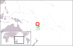
Rotuma is a Fijian dependency, consisting of Rotuma Island and nearby islets. The island group is home to a large and unique indigenous ethnic group which constitutes a recognisable minority within the population of Fiji, known as "Rotumans". Its population at the 2017 census was 1,594, although many more Rotumans live on mainland Fijian islands, totaling 10,000.
Sandy Hook is a barrier spit in Middletown Township, Monmouth County, New Jersey, United States.
The Jersey Shore is the coastal region of the U.S. state of New Jersey. Geographically, the term encompasses about 141 miles (227 km) of oceanfront bordering the Atlantic Ocean, from Perth Amboy in the north to Cape May Point in the south. The region includes Middlesex, Monmouth, Ocean, Atlantic, and Cape May counties, which are in the central and southern parts of the state.
Fiji is divided administratively into four divisions, which are further subdivided into fourteen provinces. Each province has a provincial council.
Wolfe Island is an island at the entrance to the Saint Lawrence River in Lake Ontario near Kingston, Ontario. Wolfe Island is part of Frontenac County, Ontario and the Township of Frontenac Islands. It is the largest of the Thousand Islands. The largest community on the island is Marysville. The island was part of the traditional hunting lands of the Tyendinaga Mohawk people and the original name of the island is Ganounkouesnot. It was called Grand Island. In a proclamation by the Lieutenant Governor of Upper Canada John Graves Simcoe on 16 July 1792, the island was renamed from Grand island to Wolfe island, after British General James Wolfe.
The Council of Rotuma is a municipal body on the island of Rotuma, a Fijian dependency. Owing to the unique character of Rotuma, the powers of this council are greater than those of other municipal bodies in Fiji and in some ways it approximates a legislative body, though it is in every way subordinate to the Parliament of Fiji.
Happy Valley-Goose Bay is a town in the province of Newfoundland and Labrador, Canada.
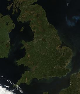
England comprises most of the central and southern two-thirds of the island of Great Britain, in addition to a number of small islands of which the largest is the Isle of Wight. England is bordered to the north by Scotland and to the west by Wales. It is closer to continental Europe than any other part of mainland Britain, divided from France only by a 33 km (21 mi) sea gap, the English Channel. The 50 km (31 mi) Channel Tunnel, near Folkestone, directly links England to mainland Europe. The English/French border is halfway along the tunnel.
The Rotuma Group is a group of volcanic islands, with Rotuma Island being the main island, located at 12°35′S177°10′E, approximately 465 km north of Fiji.
Pedro Bank is a large bank of sand and coral, partially covered with seagrass, about 80 km south and southwest of Jamaica, rising steeply from a seabed of 800 metres depth. It slopes gently from Pedro Cays to the west and north with depths from 13 to 30 metres. The total area of the bank within the 100-metre (328-foot) isobath measures 8,040 square kilometres. The area of a depth to 40 metres is triangular, 70 kilometres long east-west, and 43 kilometres wide. 2,400 square kilometres are less than 20 metres deep. With its islets, cays and rocks, a total land area of 270,000 m2 (2,906,256 sq ft), it is the location of one of the two offshore island groups of Jamaica, the other one being the Morant Cays. The bank is centered at 17°06′N78°20′W.
Rossel Island is the easternmost island of the Louisiade Archipelago, within the Milne Bay Province of Papua New Guinea. Tree Islet is situated 1.5 miles (2.4 km) to the north-west, while Wule Island is situated 1.5 miles (2.4 km) westward.
Lepa is a small village at the southeastern end of Upolu island in Samoa. The village has a population of 170. It is also the name of an electoral faipule district, Lepa Electoral Constituency, which consists of six villages, including Lepa village, with a total population of 1,429. Lepa should not be confused with the village of Lepea, situated near Apia.
The Fakpure was the secular ruler of Rotuma in the pre-European contact times. It was one of three chiefly roles with direct influence across the island of Rotuma, the other two being the Mua and the Sau. Traditionally the most senior political authority on the island, the Fakpure was one of the gagaj ‘es itu’u of the districts of Rotuma, and the convener of the island’s Council of Chiefs. After being elected as the district chief through the traditional processes, the position of fakpure was bestowed on the most senior of these district chiefs, usually the chief whose district had won the most recent war, who also received the privilege of being the first served in the politically charged kava ceremony.
Ituʻtiʻu is one of the seven districts on the island of Rotuma, a dependency of Fiji. Rotuma's capital, the village of Ahau, is located in this district. It also includes the villages of Savlei, Lau, Feavai, Tuakoi, Motusa, Ropure, Melsaʻa, and Losa.
Biak Numfor Regency is one of the regencies (kabupaten) in Papua Province of Western New Guinea in northeastern Indonesia.
The Bay of Plenty is a region of New Zealand, situated around a bight of the same name in the northern coast of the North Island. The bight stretches 260 km from the Coromandel Peninsula in the west to Cape Runaway in the east. The Bay of Plenty Region, governed by the Bay of Plenty Regional Council, incorporates several large islands in the bay, in addition to the mainland area. Called Te Moana-a-Toi in the Māori language after Toi, an early ancestor, the name 'Bay of Plenty' was bestowed by James Cook in 1769 when he noticed the abundant food supplies at several Māori villages there, in stark contrast to observations he had made earlier in Poverty Bay.
Kadavu Province is one of fourteen provinces of Fiji, and forms part of the Eastern Division, which also includes the provinces of Lau, Lomaiviti and Rotuma. Kadavu also belongs to the Burebasaga Confederacy, a hierarchy of chiefs from southern and western Fiji with Roko Tui Dreketi of Rewa as the paramount chief.
This page is based on this Wikipedia article Text is available under the CC BY-SA 4.0 license; additional terms may apply. Images, videos and audio are available under their respective licenses.