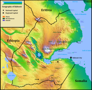
Djibouti is a country in the Horn of Africa. It is bordered by Eritrea in the north, Ethiopia in the west and south, and Somalia in the southeast. To the east is its coastline on the Red Sea and the Gulf of Aden. Rainfall is sparse, and most of the territory has a semi-arid to arid environment. Lake Assal is a saline lake which lies 155 m (509 ft) below sea level, making it the lowest point on land in Africa and the third-lowest point on Earth after the Sea of Galilee and the Dead Sea. Djibouti's major settlements include the capital Djibouti City, the port towns of Tadjoura and Obock, and the southern cities of Ali Sabieh and Dikhil. It is the 147st largest country in the world by land area, covering a total of 23,200 km2, of which 23,180 km2 is land and 20 km2 is water.

Eritrea is located in the Horn of Africa and is bordered on the northeast and east by the Red Sea, on the west and northwest by Sudan, on the south by Ethiopia, and on the southeast by Djibouti. The country has a high central plateau that varies from 1,800 to 3,000 meters (5,906–9,843 ft) above sea level. A coastal plain, western lowlands, and some 350 islands comprise the remainder of Eritrea's land mass. Eritrea has no rivers that flow year-round.

The geography of Kenya is diverse, varying amongst Kenya's 47 Counties. Kenya has a coastline on the Indian Ocean, which contains swamps of East African mangroves. Inland are broad plains and numerous hills.

Addis Ababa is the capital and largest city of Ethiopia. According to the 2007 census, the city has a population of 2,739,551 inhabitants.
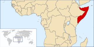
Somalia is a country located in the Horn of Africa. It is bordered by Ethiopia to the west, Djibouti to the northwest, the Gulf of Aden to the north, the Somali Sea and Guardafui Channel to the east, and Kenya to the southwest. With a land area of 637,657 square kilometers, Somalia's terrain consists mainly of plateaus, plains and highlands. Its coastline is more than 3,333 kilometers in length, the longest of mainland Africa and the Middle East. It has been described as being roughly shaped "like a tilted number seven".
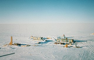
Vostok Station is a Russian research station in inland Princess Elizabeth Land, Antarctica. Founded by the Soviet Union in 1957, the station lies at the southern Pole of Cold, with the lowest reliably measured natural temperature on Earth of −89.2 °C. Research includes ice core drilling and magnetometry. Vostok was named after Vostok, the lead ship of the First Russian Antarctic Expedition captained by Fabian von Bellingshausen.

The Köppen climate classification is one of the most widely used climate classification systems. It was first published by the Russian climatologist Wladimir Köppen (1846–1940) in 1884, with several later modifications by Köppen, notably in 1918 and 1936. Later, the climatologist Rudolf Geiger introduced some changes to the classification system, which is thus sometimes called the Köppen–Geiger climate classification system.

Ali Sabieh Region is a region in southern Djibouti. With a mainland area of 2,400 square kilometres, it lies along the national border with Somalia and Ethiopia, bordering also the Dikhil Region to the west and the Arta Region to the north. Its capital is Ali Sabieh. The Arrei Mountains are the highest point in the region.
The Poles of Cold are the places in the southern and northern hemispheres where the lowest air temperatures have been recorded.
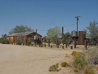
Cima is a small unincorporated community in the Mojave Desert of San Bernardino County, California, in the United States. It lies in a mountain pass on the divide between the Ivanpah Valley and the Mojave River basin, at an elevation of 4,175 feet (1,273 m). The Ivanpah Mountains and Interstate 15 are to the north, the New York Mountains are to the east, and the Providence Mountains are to the south. To the northwest is the Cima Dome & Volcanic Field National Natural Landmark, which contains Cima Dome at 5,745 feet (1,751 m) above sea level, a prominent landmark along I-15. Cima is also home to one of the densest Yucca brevifolia forests in California, located in the Cima Dome.
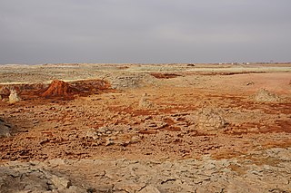
Dallol is a locality in the Dallol woreda of northern Ethiopia. Located in Administrative Zone 2 of the Afar Region in the Afar Depression, it has a latitude and longitude of 14°14′19″N40°17′38″E with an elevation of about 130 metres (430 ft) below sea level. The Central Statistical Agency has not published an estimate for this settlement's 2005 population; it has been described as a ghost town.

The climate of Puerto Rico in the. Köppen climate classification is predominately tropical rainforest. Temperatures throughout the year are warm to hot, averaging near 85 °F (29 °C) in lower elevations and 70 °F (21 °C) in the mountains. Easterly trade winds pass across the island year round while the rainy season stretches from April into November. The relatively cool trade winds are blocked by the mountains of the Cordillera Central which causes rain shadows and sharp variations in the temperature and wind speed over short distances. About a quarter of the average annual rainfall for Puerto Rico occurs during tropical cyclones, which are more frequent during La Niña years.

The climate in Brazil varies considerably mostly from tropical north to temperate zones south of the Tropic of Capricorn. Temperatures below the equator are high, averaging above 25 °C (77 °F), but not reaching the summer extremes of up to 40 °C (104 °F) in the temperate zones. There is little seasonal variation near the equator, although at times it can get cool enough to need to wear a jacket, especially in the rain. Average temperatures below the Tropic of Capricorn are mild, ranging from 13 °C (55 °F) to 22 °C (72 °F).

The climate of Ecuador varies by region, due to differences in elevation and, to a degree, in proximity to the equator.

Albania has a variety of climate systems. With its coastline facing the Adriatic and Ionian seas in the Mediterranean sea, its highlands backed upon the elevated Balkan landmass, and the entire country lying at a latitude subject to a variety of weather patterns during the winter and summer seasons, however it has a high number of climatic regions for such a small area. The coastal lowlands have typically mediterranean climate while the highlands have a continental climate. In both the lowlands and the interior, the weather varies markedly from north to south.
Malta has a Mediterranean climate according to the Köppen climate classification (Csa), with very mild winters and warm to hot summers. Rain occurs mainly in winter, with summer being generally dry. According to the Troll-Paffen climate classification and the Siegmund/Frankenberg climate classification, Malta lies within the subtropical zone, being at 35ºN latitude.

The climate of the Nordic countries is that of a region in Northern Europe that consists of Denmark, Finland, Iceland, Norway and Sweden and their associated territories, which include the Faroe Islands, Greenland and Åland. Stockholm, Sweden has on average the warmest summer of the Nordic countries, with an average maximum temperature of 23 °C (73 °F) in July; Copenhagen, Oslo and Helsinki have an average July maximum temperature of 22 °C (72 °F).
Kadugodi, also known as Kadugudi was founded by the great Cholas Dynasty. It is located in Whitefield, Bangalore in the state of Karnataka. Kadugodi comes from "kadu" & "Gudi" meaning "temple in a forest" in Kannada. It is believed that this whole area had thick vegetation consisting of soap-nut shrubs. The temple after which the place gets its name was also discovered by people venturing in to this kadu(forest) while gathering soap-nuts. This temple is of Anjaneya which is believed as udbhava murthi. Kadugudi is also referred to as "Aranayapuri" in temple related invites and publications.

Cyprus has a subtropical climate - Mediterranean and semi-arid type - according to Köppen climate classification signes Csa and BSh, with very mild winters and warm to hot summers. Snow is possible only in the Troodos mountains in the central part of the island. Rain occurs mainly in winter, with summer being generally dry.

The Ahmar Mountains is a mountain range of the Ethiopian Highlands, located in the eastern Oromia Region of Ethiopia.


