Mount Cole State Forest

Last updated

Rock cave on Cave Hill, Mount Cole State Forest Cave on Cave Hill.JPG
Rock cave on Cave Hill, Mount Cole State Forest
The Ferntree Waterfalls, Mount Cole State Forest, Victoria, Australia Ferntree waterfalls.JPG
The Ferntree Waterfalls, Mount Cole State Forest, Victoria, Australia

The Mount Cole State Forest is in western Victoria, Australia, near the town of Beaufort. The forest is around Mount Cole, which formed 390 million years ago. The Indigenous Australians, the Beeripmo balug people, called it Bereep-bereep, which means wild. The forest covers an area of 12,150 hectares, including the forest around Mount Lonarch. [1]

Contents

The forest is on a plateau which is above grassy plains. The plateau is about 760 metres above sea level. [1] High peaks in the forest include Mount Buangor (1,090 metres), Mount Cole (899 metres) and Ben Nevis (877 metres). [1]

The main trees in the southern part of the forest are Messmate (Eucalyptus obliqua), Manna Gum (Eucalyptus viminalis), and Blue Gums (Eucalyptus globulus). [2] In the north, which is drier, there are Yellow Box (Eucalyptus melliodora), and Red Stringybark (Eucalyptus macrorhyncha). [1] There is also the rare Mount Cole Grevillea, Grevillea montis-cole. [2] [3] On the high peaks there are groups of Snow Gums (Eucalyptus pauciflora). [1]

There have been 130 different birds seen in the forest, including the Powerful owl (Ninox strenua). [4] Animals include kangaroos, wallabies, echidna, koalas and possums. [2] In 1954, 160 koalas were set free in the forest to as part of a plan to re-establish the animals in Victorian forests. [1] In the 19th century, deer were introduced and Sambar deer are still living in the wet gullies in the south of the forest.

Activities in the forest include camping, walking, four wheel driving, horse riding, and bird watching. [2]

The purpose of the forest is to supply good quality hardwood logs for sawmills. [1] The management plan for the forest also protects the water catchments of several creeks which supply water to nearby towns.

On 24 June 2021, the Andrews State Government, following an extensive review and recommendation, declerated that the Mt Cole State Forest would be added to the National Park register, providing it with additional protections. The proposed Mt Buangor National Park would be staged over the next 8 years in addition to 60,000 hectares of State forests and parks also to be added. [5]

Mount Buangor State Park

An area of 1,940 hectares, the Mount Buangor State Park, was protected from logging in 1973. [1] This park includes the waterfalls on Middle Creek, and the large rock faces and caves on Cave Hill.

Mount Cole State Forest in clouds, looking from Middle Creek, Victoria, Australia Mount Cole State Forest panorama.jpg
Mount Cole State Forest in clouds, looking from Middle Creek, Victoria, Australia

Climate

As the ranges face into the prevailing westerly storm track, maximum temperatures are particularly cold for the altitude and latitude. Heavy snowfalls occur regularly throughout the year, and sub-freezing daily maximum temperatures have been recorded well into spring at Lookout Hill (965 metres). Cold weather is present even at the height of summer: on 2 February 2005, the daily maximum temperature did not exceed 4.5 °C (40.1 °F) at Lookout Hill. The ranges can be classed as having a cold mediterranean climate. Winters are extraordinarily cloudy, evident from the afternoon relative humidity readings at Lookout Hill.

Climate data for Lookout Hill (1991–2007); 965 m AMSL; 37.28° S, 143.25° E
MonthJanFebMarAprMayJunJulAugSepOctNovDecYear
Record high °C (°F)37.7
(99.9)
36.2
(97.2)
32.2
(90.0)
26.1
(79.0)
19.0
(66.2)
13.7
(56.7)
14.3
(57.7)
18.6
(65.5)
22.6
(72.7)
28.1
(82.6)
30.8
(87.4)
35.4
(95.7)
37.7
(99.9)
Mean daily maximum °C (°F)21.5
(70.7)
21.8
(71.2)
18.0
(64.4)
13.9
(57.0)
9.8
(49.6)
7.0
(44.6)
6.2
(43.2)
7.8
(46.0)
9.8
(49.6)
12.6
(54.7)
15.9
(60.6)
19.9
(67.8)
13.7
(56.6)
Mean daily minimum °C (°F)9.9
(49.8)
10.4
(50.7)
8.3
(46.9)
6.5
(43.7)
4.5
(40.1)
2.8
(37.0)
2.0
(35.6)
2.4
(36.3)
3.2
(37.8)
4.3
(39.7)
6.2
(43.2)
8.2
(46.8)
5.7
(42.3)
Record low °C (°F)−2.4
(27.7)
0.1
(32.2)
−2.5
(27.5)
−2.6
(27.3)
−5.5
(22.1)
−2.0
(28.4)
−2.5
(27.5)
−3.7
(25.3)
−2.9
(26.8)
−2.5
(27.5)
−2.1
(28.2)
−0.2
(31.6)
−5.5
(22.1)
Average precipitation mm (inches)50.6
(1.99)
50.3
(1.98)
36.1
(1.42)
51.0
(2.01)
60.6
(2.39)
110.2
(4.34)
95.1
(3.74)
87.4
(3.44)
91.0
(3.58)
71.5
(2.81)
55.2
(2.17)
42.8
(1.69)
825.3
(32.49)
Average precipitation days (≥ 0.2 mm)9.28.710.311.215.220.020.417.017.016.412.612.9170.9
Average afternoon relative humidity (%)51515766828989817668625369
Source: Australian Bureau of Meteorology; Lookout Hill
Climate data for Ben Nevis (2007–2022); 875 m AMSL; 37.23° S, 143.20° E
MonthJanFebMarAprMayJunJulAugSepOctNovDecYear
Record high °C (°F)40.8
(105.4)
40.5
(104.9)
35.6
(96.1)
29.9
(85.8)
20.9
(69.6)
14.2
(57.6)
14.6
(58.3)
17.1
(62.8)
23.7
(74.7)
29.3
(84.7)
36.1
(97.0)
39.8
(103.6)
40.8
(105.4)
Mean daily maximum °C (°F)25.4
(77.7)
23.9
(75.0)
20.3
(68.5)
15.8
(60.4)
11.0
(51.8)
8.2
(46.8)
7.3
(45.1)
8.4
(47.1)
11.8
(53.2)
15.8
(60.4)
19.0
(66.2)
22.3
(72.1)
15.8
(60.4)
Mean daily minimum °C (°F)12.5
(54.5)
12.0
(53.6)
10.3
(50.5)
8.2
(46.8)
5.4
(41.7)
3.7
(38.7)
2.6
(36.7)
2.7
(36.9)
4.1
(39.4)
6.1
(43.0)
8.2
(46.8)
10.1
(50.2)
7.2
(44.9)
Record low °C (°F)2.4
(36.3)
4.1
(39.4)
1.7
(35.1)
0.5
(32.9)
−1.0
(30.2)
−0.8
(30.6)
−1.7
(28.9)
−2.2
(28.0)
−1.7
(28.9)
−2.6
(27.3)
0.1
(32.2)
−0.3
(31.5)
−2.6
(27.3)
Average precipitation mm (inches)44.4
(1.75)
32.2
(1.27)
43.1
(1.70)
45.3
(1.78)
75.0
(2.95)
77.3
(3.04)
80.7
(3.18)
87.6
(3.45)
72.2
(2.84)
60.3
(2.37)
62.9
(2.48)
43.5
(1.71)
741.3
(29.19)
Average precipitation days (≥ 0.2 mm)7.07.09.813.120.221.622.723.518.514.312.910.3180.9
Source: Australian Bureau of Meteorology; Ben Nevis

Related Research Articles

<span class="mw-page-title-main">Mount Buffalo National Park</span> Protected area in Victoria, Australia

The Mount Buffalo National Park is a national park in the alpine region of Victoria, Australia. The 31,000-hectare (77,000-acre) national park is located approximately 350 kilometres (220 mi) northeast of Melbourne in the Australian Alps. Within the national park is Mount Buffalo, a moderately high mountain plateau, with an elevation of 1,723 metres (5,653 ft) above sea level.

<span class="mw-page-title-main">Kanangra-Boyd National Park</span> Protected area in New South Wales, Australia

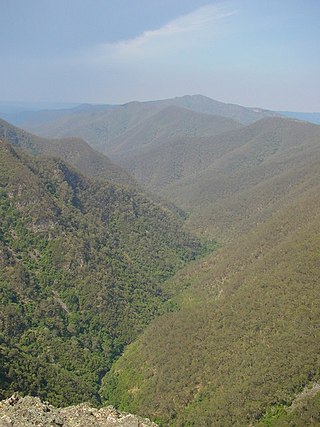
The Kanangra-Boyd National Park is a protected national park that is located in the Central Tablelands region, west of the Southern Highlands and Macarthur regions, in New South Wales, in eastern Australia. The 68,660-hectare (169,700-acre) national park is situated approximately 180 kilometres (110 mi) south-west of Sydney and is contiguous with the Blue Mountains National Park and the Nattai National Park. The park was established in 1969.

<span class="mw-page-title-main">New England National Park</span> Protected area in New South Wales, Australia

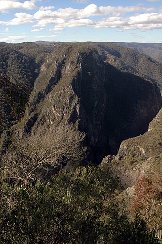
The New England National Park is a protected national park located on the Northern Tablelands in the New England region of New South Wales, Australia. The 67,303-hectare (166,310-acre) park was created in May 1935 and is situated approximately 560 kilometres (350 mi) north of Sydney, and 10 kilometres (6.2 mi) south of Waterfall Way, just 85 kilometres (53 mi) east of Armidale and 65 kilometres (40 mi) west of Coffs Harbour. The closest village to New England National Park is Ebor, located 20 kilometres (12 mi) away.

<span class="mw-page-title-main">Oxley Wild Rivers National Park</span> Protected area in New South Wales, Australia

The Oxley Wild Rivers National Park is a protected national park that is located in the Northern Tablelands region of New South Wales, Australia in the Port Macquarie-Hastings City Council and Walcha Shire councils. The 145,223-hectare (358,850-acre) park is situated 445 kilometres (277 mi) north of Sydney and is named in memory of the Australian explorer John Oxley, who passed through the area in 1818 and is one of the largest national parks in New South Wales.

<span class="mw-page-title-main">Baw Baw National Park</span> Protected area in Victoria, Australia

The Baw Baw National Park is a national park located on the boundary between the Victorian Alps and Gippsland regions of Victoria, Australia. The 13,530-hectare (33,400-acre) national park is situated approximately 120 kilometres (75 mi) east of Melbourne and 50 kilometres (31 mi) north of the Latrobe Valley. The park contains the forest covered Baw-Baw Plateau and surrounds the Mount Baw Baw Alpine Resort.

<span class="mw-page-title-main">Chiltern-Mt Pilot National Park</span> Protected area in Victoria, Australia

The Chiltern-Mt Pilot National Park is a national park that is located in the Hume region of Victoria, Australia. The 21,650-hectare (53,500-acre) national park is situated approximately 275 kilometres (171 mi) northeast of Melbourne, and extends west from Beechworth across the Hume Freeway and the Albury-Melbourne railway line to the west of Chiltern.

<span class="mw-page-title-main">D'Aguilar National Park</span> Protected area in Queensland, Australia

D'Aguilar National Park is a national park in Queensland, Australia. It contains the D'Aguilar Range and is located along the northwest of the Brisbane metropolitan area. The park is traversed by the winding scenic Mount Nebo Road and Mount Glorious Road.

<span class="mw-page-title-main">Glass House Mountains National Park</span> Protected area in Queensland, Australia

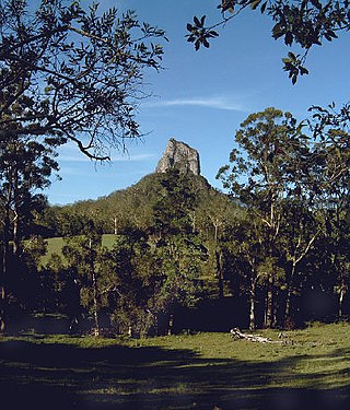
Glass House Mountains National Park is a heritage-listed national park at Glass House Mountains, Sunshine Coast Region, Queensland, Australia. It is also known as Beerburrum Forest Reserve 1. It is 70 km (43 mi) north of Brisbane and consists of a flat plain punctuated by rhyolite and trachyte volcanic plugs, the cores of extinct volcanoes that formed 26 million to 27 million years ago. The mountains would once have had pyroclastic exteriors, but these have eroded away.

<span class="mw-page-title-main">Mount Baw Baw</span> Mountain in Victoria, Australia

Mount Baw Baw is a mountain summit on the Baw-Baw Plateau of the Great Dividing Range, located in Victoria, Australia. The name is from the Woiwurrung language spoken by Eastern Kulin people. It is of uncertain meaning, but possibly signifies, echo, or ghost.

<span class="mw-page-title-main">Mount Keira</span> Suburb of Wollongong, New South Wales, Australia

Mount Keira is a suburb and mountain in the Illawarra region of New South Wales, Australia.

<span class="mw-page-title-main">Grose Valley</span> Valley in the Blue Mountains, New South Wales, Australia

The Grose Valley is a rugged valley in the Blue Mountains, New South Wales, Australia. It has been formed by the Grose River, the headwaters of which are in the Mount Victoria area. The valley is located between the Great Western Highway and Bells Line of Road, the two major routes across the Blue Mountains. The majority of the valley falls within the Blue Mountains National Park.

<span class="mw-page-title-main">Illawarra escarpment</span> Mountain range in New South Wales, Australia

The Illawarra escarpment, or officially the Illawarra Range, is the fold-created cliffs and plateau-eroded outcrop mountain range west of the Illawarra coastal plain south of Sydney, in the state of New South Wales, Australia. The range encloses the Illawarra region which stretches from Stanwell Park in the north to Kiama, Gerringong and the Shoalhaven River in the south.

Mount Kaputar, a mountain with an elevation of 1,489 metres (4,885 ft) above sea level, is located near Narrabri in northern New South Wales. It is part of the Nandewar Range and has been preserved within the Mount Kaputar National Park. The mountain is a prominent landmark for travellers on the Newell Highway as it rises abruptly from the plains. In the cold of winter the mountain may receive a light dusting of snow.

<i>Grevillea montis-cole</i> Species of shrub in the family Proteaceae endemic to Victoria, Australia

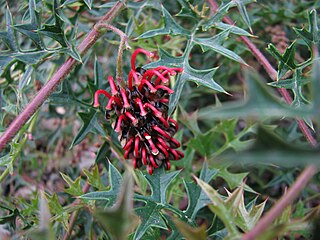
Grevillea montis-cole, commonly known as Mount Cole grevillea, is a species of flowering plant in the family Proteaceae and is endemic to central-western Victoria, Australia. It is a shrub with divided leaves with 5 to 15 lobes, the end lobes more or less triangular to narrowly oblong and sharply-pointed, and clusters of greenish to fawn and dull purplish flowers.

<span class="mw-page-title-main">Mount Buangor State Park</span> Protected area in Victoria, Australia

Mount Buangor State Park is located 60 kilometres west of Ballarat, Victoria in Bayindeen. The 2400-hectare park takes in varied eucalypt forest, creek flats, a waterfall, steep escarpments, and the area's highest peak, Mount Buangor. The park contains a 15 km network of walking trails.

<span class="mw-page-title-main">Mount Cobbler</span> Mountain in Victoria, Australia

Mount Cobbler is a mountain located in the Alpine National Park to the east of Mansfield in north-eastern Victoria, Australia. Its summit rises to 1,628 metres (5,341 ft) above sea level. The peak and surrounding Cobbler land system are composed of sedimentary rocks, dating to the Lower Carboniferous period, some 359 to 318 million years ago.

The Burrinjuck Nature Reserve is a protected nature reserve on the south west slopes of New South Wales, Australia. The 5,250-hectare (13,000-acre) reserve is located adjacent to the Burrinjuck Dam, with 5,118 hectares of the reserve located on the northern side of the reservoir, and the remaining 89 hectares located on the southern side of the reservoir to the northeast of Black Andrew Nature Reserve. It includes land formerly managed as the Burrinjuck State Forest and Burrinjuck State Recreation Area.

<span class="mw-page-title-main">Toolangi State Forest</span>

The Toolangi State Forest region in southern Australia extends from Mount Monda in the south up to Murrindindi in the north and includes the township of Toolangi. The forest is mainly eucalypt forest that has regrown from the 1939 Victoria Bushfires.

Bangadilly National Park is a national park located around 20 km west of Bowral in the Southern Highlands of New South Wales. Established in 2001, it is made up of three separate, similarly sized areas of land totalling 2,141 hectares in area. It consists of sandstone plateaus and gorges bordering the Wingecarribee River.

<span class="mw-page-title-main">Bungonia National Park</span> Protected area in New South Wales, Australia

Bungonia National Park is a protected national park that is located in the Australian state of New South Wales, roughly 40 kilometres (25 mi) east of the city of Goulburn and 122 km (76 mi) south-west of Sydney. The approximately 15 square kilometres (5.8 sq mi) park borders the Bungonia State Conservation Area to the South, Morton National Park to the East, and Bungonia Creek to the North. Only a relatively recent addition to the national parks registry, Bungonia was originally protected as a water reserve to prevent contamination of the Shoalhaven River in the mid-late 19th century.

References

  1. 1 2 3 4 5 6 7 8 "Mount Cole State Forest". Friends Of Mt Cole & The Pyrenees Ranges Inc. 2013. Retrieved 24 August 2013.
  2. 1 2 3 4 "Mount Cole State Forest" (PDF). pdf.js. 2012. Retrieved 24 August 2013.
  3. "Grevillea montis-cole R.V.Sm". Australian National Botanical Gardens. 2013. Retrieved 25 August 2013.
  4. "Timber harvesting in Mt Cole State Forest" (PDF). agriculture.vic.gov.au. September 2013. Archived from the original (PDF) on 4 October 2017. Retrieved 4 October 2017.
  5. "BREAKING NEWS: Milestone for nature protection as Andrews Government announces new national parks – Victorian National Parks AssociationVictorian National Parks Association". 24 June 2021.