Related Research Articles

The Shire of Yarra Ranges, also known as Yarra Ranges Council, is a local government area in Victoria, Australia, located in the outer eastern and northeastern suburbs of Melbourne extending into the Yarra Valley and Dandenong Ranges. It has an area of 2,468 square kilometres (953 sq mi), of which 3% is classified as urban. In June 2018, it had a population of 158,173.

The Dandenong Ranges are a set of low mountain ranges in Victoria, Australia, approximately 35 km (22 mi) east of the state capital Melbourne. A minor branch of the Great Dividing Range, the Dandenongs consist mostly of rolling hills, rising to 633 m (2,077 ft) at Mount Dandenong, as well as steeply weathered valleys and gullies covered in thick temperate rainforest, predominantly of tall mountain ash trees and dense ferny undergrowth. The namesaked Dandenong Creek and most of its left-bank tributaries originate from headwaters in these mountain ranges. Two of Melbourne's most important storage reservoirs, the Cardinia and Silvan Reservoir, are also located within the Dandenongs.

Mount Evelyn is a suburb in Melbourne, Victoria, Australia, 37 km east of Melbourne's central business district, located within the Shire of Yarra Ranges local government area. Mount Evelyn recorded a population of 9,799 at the 2021 census.

The Division of Casey is an Australian electoral division in the state of Victoria. The division was created in 1969 and is named for Richard Casey, who was Governor-General of Australia 1965–69.
Olinda Creek is a major tributary of the Yarra River in Victoria, Australia. Its origins are in the Dandenong Ranges, and it is notable for passing through the settlement of Lilydale before joining with the Yarra near Coldstream.
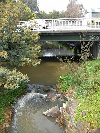
The Mount Evelyn Aqueduct Walk uses part of the Mount Evelyn Aqueduct which once cut the town of Mount Evelyn, Victoria, Australia, in two. The Aqueduct was decommissioned on 7 February 1972, but the high costs of purchase and filling caused Lillydale Council to repeatedly defer negotiations to purchase the land from the Melbourne and Metropolitan Board of Works (MMBW).

The Prospect Reservoir is a heritage-listed 50,200-megalitre potable water supply and storage reservoir created by the Prospect Dam, across the Prospect Creek located in the Western Sydney suburb of Prospect, in New South Wales, Australia. The eastern bounds of the reservoir are a recreational area and the western periphery are within the bounds of Western Sydney Parklands. It was added to the New South Wales State Heritage Register on 18 November 1999.

Mountain Park Dam is located just upstream of Snyder Dam, on Otter Creek near Mountain Park, Oklahoma. Snyder Lake was drained to accommodate construction of Mountain Park Dam, then restored upon completion of construction, which was performed by O'Neal Construction, Inc. of Ann Arbor, MI. The lake is maintained at sufficient elevation to provide a plunge pool for water released or spilled from the dam. Mountain Park dam impounds the waters of Tom Steed Reservoir.

Rifle Creek Dam is owned by Mount Isa Mines. A concrete arch dam, it was constructed in 1929 to replace the earlier Experimental Dam as the primary water supply to the town of Mt Isa, and the mine. The initial full supply volume was 600 million gallons, the spillway was raised in 1953, and the current full capacity is 9,500 megalitres. The dam was replaced as Mt Isa's primary water supply by Lake Moondarra following the completion of that dam in 1958. Rifle Creek Dam now serves as a backup water supply for Mt Isa Mines.

The Shire of Lillydale was a local government area about 40 kilometres (25 mi) northeast of Melbourne, the state capital of Victoria, Australia. The shire covered an area of 397.49 square kilometres (153.5 sq mi), and existed from 1856 until 1994.

The Wyaralong Dam is a mass concrete gravity dam with an un-gated spillway across the Teviot Brook that is located in the South East region of Queensland, Australia. The main purpose of the dam is for supply of potable water for the Scenic Rim region. The dam was initiated by the Queensland Government in 2006 as a result of the prolonged Millennium drought which saw the catchment areas of South East Queensland's dams receive record low rain. It was completed in 2011.
The Weston Aqueduct is an aqueduct operated by the Massachusetts Water Resources Authority (MWRA). Now part of the MWRA backup systems, it was designed to deliver water from the Sudbury Reservoir in Framingham to the Weston Reservoir in Weston. The 13.5-mile (21.7 km) aqueduct begins at the Sudbury Dam, and passes through the towns of Southborough, Framingham, Wayland, and Weston. In 1990, the route, buildings and bridges of the aqueduct were added to the National Register of Historic Places as the Weston Aqueduct Linear District.

Melbourne is the capital city of southeastern Australian state of Victoria and also the nation's second most populous city, and has been consistently voted one of the most liveable cities in the world. Located on the northern/eastern coastal plains of Port Phillip Bay, the city is one of the drier capital cities in Australia, but due to its relatively flat terrain and the runoffs fed from surrounding highlands, still has many lakes, ponds and wetlands, mainly managed by Melbourne Water and Parks Victoria. The larger waterbodies are used for water sports, mostly boating but some are used for recreational activities like swimming, water skiing or model boating.
The O'Shannassy Reservoir is an Australian man-made water supply dammed reservoir. The 3.123 GL water store across the O'Shannassy River is located near the locality of McMahons Creek, approximately 80 kilometres (50 mi) east of Melbourne, Victoria. The dam that creates the impoundment is called the O'Shannassy Dam.
The Greater Winnipeg Water District Aqueduct (GWWDA) is an aqueduct that supplies the city of Winnipeg, Manitoba, with water from Shoal Lake, Kenora District, Ontario. Winnipeg has relied on the lake as its source for safe drinking water since the aqueduct was put in service in 1919 at a cost of nearly CDN $16 million.

The Nidd Aqueduct is an aqueduct or man-made watercourse in North Yorkshire, England. It feeds water from Angram and Scar House reservoirs in upper Nidderdale, North Yorkshire 32 mi (51 km) to Bradford in West Yorkshire. The aqueduct supplies 21,000,000 imp gal (95,000 m3) of water per day to Chellow Heights water treatment works. The aqueduct and the reservoirs it connects to are all maintained by Yorkshire Water.

The Cooks River Sewage Aqueduct is a heritage-listed sewage aqueduct located at Pine Street, Earlwood, New South Wales, Australia. It crosses the Cooks River to Thornley Street, Marrickville. It was designed by Sewerage Construction Branch and NSW Department of Public Works and built during 1895 by J. F. Carson, contractor. The property is owned by Sydney Water, an agency of the Government of New South Wales. It was added to the New South Wales State Heritage Register on 18 November 1999.

The Wolli Creek Aqueduct is a heritage-listed sewage aqueduct located at Unwin Street, Earlwood, City of Canterbury-Bankstown, New South Wales, Australia.

Water management in Victoria deals with the management of water resources in and by the Australian State of Victoria.

The Murdock Canal, also known as the Provo Reservoir Canal and the Provo River Aqueduct, is a 23 mile water conveyance system that diverts water from the Provo River and other water storage systems to water users in Utah County. The canal starts at the Murdock Diversion Dam which is located at the mouth of Provo Canyon in Provo, Utah. The canal runs completely underground through Utah Valley and ends at the Jordan Aqueduct in Lehi, Utah. It carries water through the cities of Orem, Lindon, Pleasant Grove, Cedar Hills, American Fork, Highland, and Lehi. The canal is the largest of three primary water conveyance systems in Salt Lake Valley, the other systems being the Jordan Aqueduct and the Salt Lake Aqueduct. The water capacity of the Murdock Canal more than doubles that of either the Jordan Aqueduct or Salt Lake Aqueduct at 612 cfs.
References
- Chapter 38 of Tracks to Trails, a history of Mt Evelyn, paraphrased from Louise Hordern's pamphlet.