Related Research Articles

The Columbia River is a major river which flows through southern British Columbia, central Washington and forms a portion of the Washington - Oregon boundary before emptying into the Pacific Ocean. It is the largest river in the Pacific Northwest region of the United States. The river rises in the Rocky Mountains of British Columbia, Canada. It flows northwest and then south into the U.S. state of Washington, then turns west to form most of the border between Washington and the state of Oregon before emptying into the Pacific Ocean. The river is 1,243 miles long, and its largest tributary is the Snake River. Its drainage basin is roughly the size of France and extends into seven of the United States plus a Canadian province. The fourth-largest river in the United States by volume, the Columbia has the greatest flow of any North American river entering the Pacific. The Columbia has the 36th greatest discharge of any river in the world.

The Cowlitz River is a river in the state of Washington in the United States, a tributary of the Columbia River. Its tributaries drain a large region including the slopes of Mount Rainier, Mount Adams, and Mount St. Helens.
The British Columbia Electric Railway (BCER) was an historic railway which operated in southwestern British Columbia, Canada. Originally the parent company for, and later a division of, BC Electric Company, the BCER assumed control of existing streetcar and interurban lines in southwestern British Columbia in 1897, and operated the electric railway systems in the region until the last interurban service was discontinued in 1958. During and after the streetcar era, BC Electric also ran bus and trolleybus systems in Greater Vancouver and bus service in Greater Victoria; these systems subsequently became part of BC Transit, and the routes in Greater Vancouver eventually came under the control of TransLink. Trolley buses still run in the City of Vancouver with one line extending into Burnaby.

The Sandy River is a 56-mile (90 km) tributary of the Columbia River in northwestern Oregon in the United States. The Sandy joins the Columbia about 14 miles (23 km) upstream of Portland.

The Bull Run Hydroelectric Project was a Portland General Electric (PGE) development in the Sandy River basin in the U.S. state of Oregon. Originally built between 1908 and 1912 near the town of Bull Run, it supplied hydroelectric power for the Portland area for nearly a century, until it was removed in 2007 and 2008. The project used a system of canals, tunnels, wood box flumes and diversion dams to feed a remote storage reservoir and powerhouse. The entire project was removed because of rising environmental costs. Marmot Dam on the Sandy River was demolished in 2007, and the Little Sandy Dam on the Little Sandy River was taken down in 2008.

The Bull Run River is a 21.9-mile (35.2 km) tributary of the Sandy River in the U.S. state of Oregon. Beginning at the lower end of Bull Run Lake in the Cascade Range, it flows generally west through the Bull Run Watershed Management Unit (BRWMU), a restricted area meant to protect the river and its tributaries from contamination. The river, impounded by two artificial storage reservoirs as well as the lake, is the primary source of drinking water for the city of Portland, Oregon.

Folsom Powerhouse State Historic Park is a historical site preserving an 1895 alternating current (AC) hydroelectric power station—one of the first in the United States.

Timothy Lake is a lake about 50 miles (80 km) southeast of Portland, Oregon, United States. It is in proximity to Clear Lake and an impoundment of the Oak Grove Fork Clackamas River.

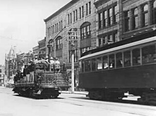
Bull Run is an unincorporated community in Clackamas County, Oregon, United States. It is located about 5 miles (8.0 km) northeast of Sandy, near the Bull Run River and the powerhouse of the defunct Mount Hood Railway and Power Company.

Cazadero is an unincorporated historic locale in Clackamas County, Oregon, United States. Cazadero was a station on the Estacada interurban railway line of the Portland Railway, Light and Power Company (PRL&P) and later Portland Electric Power Company (PEPCO), near where the power plant of the PEPCO-owned Cazadero Dam was located on the Clackamas River.
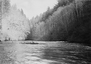
The Little Sandy River is a tributary, roughly 15 miles (24 km) long, of the Bull Run River in the U.S. state of Oregon. Forming west of Mount Hood in the Mount Hood National Forest, it flows generally west, roughly parallel to the Sandy River to the south. Its entire course lies in Clackamas County, and most of its main stem and tributaries are within the Bull Run Watershed Management Unit (BRWMU), a restricted zone that protects Portland's main water supply.

The South Fork Bull Run River is a tributary, about 6 miles (9.7 km) long, of the Bull Run River in the U.S. state of Oregon. Part of the system that provides drinking water to the city of Portland, it flows generally west through a protected part of the Mount Hood National Forest in Clackamas County. It joins the Bull Run River at Bull Run Reservoir 2, about 8 miles (13 km) from the larger stream's confluence with the Sandy River.
The Portland Railway, Light and Power Company (PRL&P) was a railway company and electric power utility in Portland, Oregon, United States, from 1906 until 1924.
The North Fork Bull Run River is a tributary, about 6 miles (10 km) long, of the Bull Run River in the U.S. state of Oregon. Part of the system that provides drinking water to the city of Portland, it flows generally south through a protected part of the Mount Hood National Forest in Multnomah County. It joins the Bull Run River at Bull Run Reservoir 1.
Blazed Alder Creek is a tributary, about 4 miles (6 km) long, of the Bull Run River in the U.S. state of Oregon. Part of the system that provides drinking water to the city of Portland, it flows generally north through a protected part of the Mount Hood National Forest in Clackamas and Multnomah counties. The creek is named after a 24-inch (61 cm) blazed (marked) alder tree that was used as a benchmark during early watershed surveys.

Fir Creek is a tributary, about 5 miles (8 km) long, of the Bull Run River in the U.S. state of Oregon. Part of the system that provides drinking water to the city of Portland, it flows generally northwest through a protected part of the Mount Hood National Forest in Clackamas and Multnomah counties. It joins the Bull Run River at the upper end of Bull Run Reservoir 1, about 14 miles (23 km) from the larger stream's confluence with the Sandy River.

The North Fork Kings River is a 40.3-mile (64.9 km) tributary of the Kings River, in the U.S. state of California. The river's main stem is entirely within Fresno County, and its watershed drains about 387 square miles (1,000 km2) of the southern Sierra Nevada mountain range.
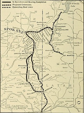
The Spokane and Inland Empire Railroad Company (S.&I.E.R.R.Co.) was an electrified interurban railway operating in Spokane, Washington and vicinity, extending into northern and central Idaho. The system originated in several predecessor roads beginning c. 1890, incorporated in 1904, and ran under its own name to 1929. It merged into the Great Northern Railway and later, the Burlington Northern Railroad, which operated some roads into the 1980s.

The Big Creek Hydroelectric Project is an extensive hydroelectric power scheme on the upper San Joaquin River system, in the Sierra Nevada of central California. The project is owned and operated by Southern California Edison (SCE). The use and reuse of the waters of the San Joaquin River, its South Fork, and the namesake of the project, Big Creek – over a vertical drop of 6,200 ft (1,900 m) – have over the years inspired a nickname, "The Hardest Working Water in the World".
References
- Taylor, Barbara (1998). Salmon and Steelhead Runs and Related Events of the Sandy River Basin; A Historical Perspective. Portland, OR.: Portland General Electric Company.