
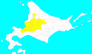
Ishikari Subprefecture is a subprefecture of Hokkaido Prefecture, Japan, located in the western part of the island. The subprefecture covers 3,539.86 square kilometres (1,366.75 sq mi) and in 2011 had a population of 2,334,241. The subprefecture takes its name from the Ishikari River, the third longest in Japan, which flows through western Hokkaido and empties into the Sea of Japan in the city of Ishikari. There are 6 cities, three towns, and one village under its jurisdiction. Sapporo is both the capital of Hokkaido Prefecture and Ishikari Subprefecture. Shikotsu-Toya National Park is located in the southern part of the subprefecture, and Shokanbetsu-Teuri-Yagishiri Quasi-National Park in the north.
Ebetsu is a city in Ishikari Subprefecture, Hokkaido, Japan.

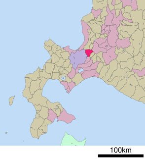
Ishikari is a city located in Ishikari Subprefecture, Hokkaido, Japan.

Bibai is a city located in Sorachi Subprefecture, Hokkaido, Japan.

Tōbetsu is a town located in Ishikari, Hokkaido, Japan.

Shinshinotsu is a village located in Ishikari, Hokkaido, Japan.

Kamikawa is a district located in Kamikawa Subprefecture, Hokkaido, Japan. Confusingly, there is a district of the same name, Kamikawa (Teshio) District, in the h. subprefecture. In 1869, when Hokkaido was divided into 11 provinces and 86 districts, this Kamikawa District was placed under Ishikari Province. The name is derived from its location at the headwaters of the Ishikari River, whereas the other Kamikawa District is named after the headwaters of the Teshio River. There is a third district in Hokkaido with the same name, see Kamikawa (Tokachi) District.
Ishikari Province was a short-lived province located in Hokkaidō. It corresponded to modern-day Ishikari Subprefecture minus Chitose and Eniwa, all of Sorachi Subprefecture and the southern half of Kamikawa Subprefecture excluding Shimukappu
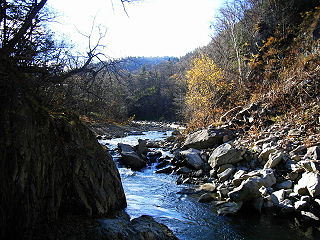
The Toyohira River is a river in Hokkaidō prefecture, Japan. It is 72.5 km in length and has drainage area of 894.7 km². It is a tributary of the Ishikari River.
Mount Yuniishikari is part of the Ishikari Mountains, Hokkaidō, Japan.
The Ishikari Mountains is a range of volcanic mountains in central Hokkaidō, Japan. The mountain range is made up from the Daisetsuzan Volcanic Group and the Tomuraushi Volcanic Group. The volcanoes are part of the Kurile arc of the Pacific ring of fire.
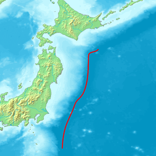
The Northeastern Japan Arc, also Northeastern Honshū Arc, is an island arc on the Pacific Ring of Fire. The arc runs north to south along the Tōhoku region of Honshū, Japan. It is the result of the subduction of the Pacific Plate underneath the Okhotsk Plate at the Japan Trench. The southern end of the arc converges with the Southwestern Japan Arc and the Izu-Bonin-Mariana Arc at the Fossa Magna (ja) at the east end of the Itoigawa-Shizuoka Tectonic Line (ITIL). This is the geologic border between eastern and western Honshū. Mount Fuji is at the point where these three arcs meet. To the north, the Northeastern Japan arc extends through the Oshima Peninsula of Hokkaidō. The arc converges in a collision zone with the Sakhalin Island Arc and the Kuril arc in the volcanic Ishikari Mountains of central Hokkaidō. This collision formed the Teshio and Yūbari Mountains.
Mount Mikuni is part of the Ishikari Mountains, Hokkaidō, Japan.

Ishikari-Futomi Station is a railway station on the Sasshō Line in Tōbetsu, Hokkaidō, Japan, operated by the Hokkaido Railway Company. The station is numbered G12.

Ishikari-Kanazawa Station is a railway station on the Sasshō Line in Tōbetsu, Ishikari District, Hokkaidō, Japan, operated by the Hokkaido Railway Company.
Ishikari, Hokkaidō (石狩) is the name of a city in Hokkaido, Japan.

The Zenibako River (銭函川) runs from Otaru, Hokkaidō, Hokkaidō, Japan and ends in the Sea of Japan. It is a Normal Class River of the Zenibako River System under Japanese River Law.


