Mount Vernon is the Virginia estate of George Washington, the first President of the United States.
Germantown or German Town may refer to:
Mount Pleasant may refer to:

Mount Rainier is a city in Prince George's County, Maryland, United States, bordering Washington D.C. The population was 8,333 at the 2020 census. Mount Rainier is contained between the Northwest Branch Anacostia River, Cedar Lane Alley, and 34th Street to the north, 37th Street and 37th Place to the northeast, Upshur Street and Queens Chapel Road to the west, the CSX Capital Subdivision train tracks to the east, and Eastern Avenue NE to the south. Mount Rainier got its start as a streetcar suburb, when tracks were laid for the 82 Streetcar Line. According to local tradition, surveyors from the Pacific Northwest named the town, giving the streets names such as Shasta and Cascade. Historic U.S. 1 runs through the center of the town and serves as the main street and central business district.
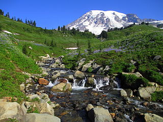
Mount Rainier National Park is an American national park located in southeast Pierce County and northeast Lewis County in Washington state. The park was established on March 2, 1899, as the fourth national park in the United States, preserving 236,381 acres including all of Mount Rainier, a 14,410-foot (4,390 m) stratovolcano. The mountain rises abruptly from the surrounding land with elevations in the park ranging from 1,600 feet to over 14,000 feet (490–4,300 m). The highest point in the Cascade Range, Mount Rainier is surrounded by valleys, waterfalls, subalpine meadows, and 91,000 acres of old-growth forest. More than 25 glaciers descend the flanks of the volcano, which is often shrouded in clouds that dump enormous amounts of rain and snow.

The Mount Baker–Snoqualmie National Forest in Washington is a National Forest extending more than 140 miles (230 km) along the western slopes of the Cascade Range from the Canada–US border to the northern boundary of Mount Rainier National Park. Administered by the United States Forest Service, the forest is headquartered in Everett. There are local ranger district offices in North Bend and Skykomish.
Watts is plural for watt, the unit of power.
Rainier may refer to the following:
The name Pisgah may refer to:

Takoma, Washington, D.C., is a neighborhood in Washington, D.C. It is located in Advisory Neighborhood Commission 4B, in the District's Fourth Ward, within the northwest quadrant. It borders the city of Takoma Park, Maryland.
Woodlands may back refer to:
Tahoma is a name for the volcano otherwise known as Mount Rainier.
Forest Hill or Forrest Hill may refer to:
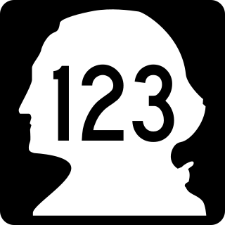
State Route 123 (SR 123) is a state highway in the Gifford Pinchot National Forest and Mount Rainier National Park east of Mount Rainier in the U.S. state of Washington. Located in the counties of Lewis and Pierce, the 16.34-mile (26.30 km) long roadway extends through a heavily forested canyon from U.S. Route 12 (US 12) to SR 410. First established as a branch of State Road 5 in 1923, the designation of SR 123 has changed from a branch of Primary State Highway 5 (PSH 5) in 1937 to SR 143 during the 1964 highway renumbering and SR 123 in 1967. The northern terminus of the highway, Cayuse Pass, is closed annually and in late 2006, the Hanukkah Eve windstorm of 2006 washed out a 10.90-mile (17.54 km) long segment of the roadway.

State Route 165 (SR 165) is a state highway in Pierce County, Washington, United States. It travels north–south along the Carbon River between Mount Rainier National Park near Mowich Lake to a junction with SR 410 in Buckley. The highway passes through the towns of Carbonado and Wilkeson and also intersects SR 162 near South Prairie. SR 165 is the only state highway in Washington to include an unpaved section.

Mount Baker station is a light rail station located in Seattle, Washington. It is situated between the Columbia City and Beacon Hill stations on the 1 Line, which runs from Seattle–Tacoma International Airport to Downtown Seattle, the University of Washington, and Northgate as part of the Link light rail system. The elevated station consists of two side platforms located west of the intersection of Rainier Avenue and Martin Luther King Jr. Way in the Mount Baker neighborhood, part of Seattle's Rainier Valley.
Rainier National Forest was established in Washington on March 2, 1907, when its name was changed from Mount Rainier Forest Reserve. The Mount Rainier Forest Reserve was established by the General Land Office on February 22, 1897 from the Pacific Forest Reserve and other lands with 2,234,880 acres (9,044.2 km2). In 1905 federal forests were transferred to the U.S. Forest Service. On October 13, 1933, Rainier was divided between Columbia, Snoqualmie and Wenatchee National Forests. Its lands exists presently as portions of Mount Baker-Snoqualmie, Wenatchee and Gifford Pinchot National Forests.
The Mount Rainier Historic District is a national historic district located at Mount Rainier, Prince George's County, Maryland, which began as a streetcar suburb located northeast of Washington, D.C. The district was built on a gently rolling rural landscape from about 1900 to 1940. The district contains more than 1,000 buildings, which are modestly scaled, detached, single-family, frame houses sited closely together with common setbacks. It consists primarily of single-family homes, with some small apartment buildings, a few duplexes, and single family homes that include a small storefront, usually located at the corner of an intersection. With the exception of five churches and a bank building known to have been designed by local architects, the remainder of the district's buildings are vernacular in character. Some homes contain Queen Anne detailing.

Mount Rainier, also known as Tahoma, is a large active stratovolcano in the Cascade Range of the Pacific Northwest in the United States. The mountain is located in Mount Rainier National Park about 59 miles (95 km) south-southeast of Seattle. With a summit elevation of 14,417 ft (4,394 m), it is the highest mountain in the U.S. state of Washington and the Cascade Range, the most topographically prominent mountain in the contiguous United States, and the tallest in the Cascade Volcanic Arc.