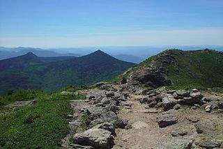
Mount Washington, called Agiocochook by some Native American tribes, is the highest peak in the Northeastern United States at 6,288.2 ft (1,916.6 m) and the most topographically prominent mountain east of the Mississippi River.

The White Mountains are a mountain range covering about a quarter of the state of New Hampshire and a small portion of western Maine in the United States. They are part of the northern Appalachian Mountains and the most rugged mountains in New England. The range is heavily visited due to its proximity to Boston and, to a lesser extent, New York City and Montreal, Quebec, Canada.

John Greenleaf Whittier was an American Quaker poet and advocate of the abolition of slavery in the United States. Frequently listed as one of the fireside poets, he was influenced by the Scottish poet Robert Burns. Whittier is remembered particularly for his anti-slavery writings, as well as his book Snow-Bound.

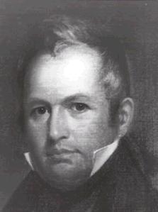
Joseph Ritner was the eighth Governor of the commonwealth of Pennsylvania, elected as a member of the Anti-Masonic Party. He was elected Governor of Pennsylvania in the 1835 Pennsylvania gubernatorial election, and served from 1835 to 1839. Controversy surrounding his 1838 electoral defeat led to the Buckshot War. In 1856, Governor Ritner was a delegate to the first Republican National Convention in Philadelphia.

Bretton Woods is an area within the town of Carroll, New Hampshire, United States, whose principal points of interest are three leisure and recreation facilities. Being virtually surrounded by the White Mountain National Forest, the vista from Bretton Woods toward Mount Washington and the Presidential Range includes no significant artificial structures other than the Mount Washington Cog Railway and the Mount Washington Hotel.

Olympus, or Chionistra, at 1,952 metres (6,404 ft), is the highest point in Cyprus. It is located in the Troodos Mountains of Cyprus. Mount Olympus peak and the "Troodos Square" fall under the territory of Platres in Limassol District. A British long range radar currently operates at Mount Olympus' peak.

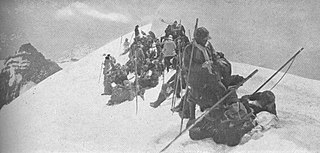
The Mountaineers is an alpine club serving the state of Washington. Founded in 1906, it is organized as an outdoor recreation, education, and conservation 501(c)(3) nonprofit, and is based in Seattle, Washington. The Mountaineers host a wide range of outdoor activities, primarily alpine mountain climbing and hikes. The club also hosts classes, training courses, and social events.
State Route 542 (SR 542) is a 57.24-mile-long (92.12 km) state highway in the U.S. state of Washington, serving Mount Baker in Whatcom County. SR 542 travels east as the Mount Baker Highway from an interchange with Interstate 5 (I-5) in Bellingham through the Nooksack River valley to the Mt. Baker Ski Area at Austin Pass. It serves as the main highway to Mount Baker and the communities of Deming, Kendall, and Maple Falls along the Nooksack River. The highway was constructed in 1893 by Whatcom County as a wagon road between Bellingham and Maple Falls and was added to the state highway system as a branch of State Road 1 in 1925. The branch was transferred to Primary State Highway 1 (PSH 1) during its creation in 1937 and became SR 542 during the 1964 highway renumbering.

Mt. Norquay is a mountain and ski resort in Banff National Park, Canada that lies directly northwest of the Town of Banff. The regular ski season starts early December and ends mid-April. Mount Norquay is one of three major ski resorts located in the Banff National Park.

The Lake Louise Ski Resort & Summer Gondola is a ski resort in western Canada, located in Banff National Park near the village of Lake Louise, Alberta. Located 57 km (35 mi) west of Banff, Lake Louise is one of three major ski resorts within Banff National Park.

Buckhorn Ski and Snowboard Club is located roughly 40 mi (64 km) north of Los Angeles in the Angeles National Forest. The U.S. Department of Agriculture owns the land and the United States Forest Service administers the area. It is a cooperative club with nominal dues but all members are expected to contribute time to maintenance.

Baldy Mountain Resort is a family friendly ski resort overlooking the Okanagan Valley in southern British Columbia just north of the Washington state border. Its road access is via McKinney Road from Oliver and from BC Highway 33 north of Bridesville and BC Highway 3 west of Rock Creek, in the Boundary Country. Air access from Penticton Regional Airport. The summit is in the Okanagan Highland, an intermediary plateau-like area between the Monashee Mountains to the east and the Okanagan Valley immediately below to the west.

Mount Pilchuck State Park is a public recreation area located seven miles (11 km) east of Granite Falls, Washington, on the western edges of the Cascade Mountains. The state park features 1,903 acres (770 ha) of alpine scenery, recreational activities, and Mount Pilchuck itself. The main point of interest is the 3-mile (4.8 km) trail to the peak and the old fire lookout located on the summit, 5,324 feet (1,623 m) above sea level.

Mt. Whittier was a ski area located in West Ossipee, New Hampshire. Though it shared a name with a nearby mountain in the Ossipee Range, the ski area was actually located on Nickerson Mountain.

Nickerson Mountain is a mountain located in Carroll County, New Hampshire, in the northeastern Ossipee Mountains. The peak was also once known as Mount Whittier, however the USGS has since labelled a mountain to the immediate west with the name.

Mount Whittier is a mountain in Carroll County, New Hampshire, in the northern Ossipee Mountains. Named after John Greenleaf Whittier, the peak is not to be confused with nearby Nickerson Mountain, which was once known as Mount Whittier.

Jug End State Reservation and Wildlife Management Area is a public recreation area located in the towns of Egremont and Mount Washington, Massachusetts. The reservation occupies the site of the former Jug End Barn resort, which has been allowed to return to a natural state. Mount Everett State Reservation is adjacent to the south. It is managed by the Department of Conservation and Recreation.

The 1965 NCAA Skiing Championships were contested at the Crystal Mountain ski resort in the Mount Baker-Snoqualmie National Forest in Pierce County, Washington at the 12th annual NCAA-sanctioned ski tournament to determine the individual and team national champions of men's collegiate alpine, cross country skiing, and ski jumping in the United States.

Mount Whittier is a prominent 5,883-ft mountain summit located in Mount St. Helens National Volcanic Monument, in the Gifford Pinchot National Forest, in Skamania County of southwest Washington state. It is situated in the Cascade Range, 2 mi (3.2 km) north of Spirit Lake, and 1.7 mi (2.7 km) northeast of The Dome. Its closest neighbor is Mount Margaret, 0.93 mi (1.50 km) to the south, and the nearest higher neighbor is Mount St. Helens, 9 mi (14 km) to the south. Whittier is the second-highest peak in the Mount St. Helens area, after Mt. St. Helens. Although modest in elevation, relief is significant as the summit rises 2,000 feet above the head of Coldwater Creek valley in 0.6 mi (0.97 km). Precipitation runoff from Mount Whittier drains into tributaries of the North Fork Toutle River.


