
Salt Lake County is located in the U.S. state of Utah. As of the 2020 United States census, the population was 1,185,238, making it the most populous county in Utah. Its county seat and largest city is Salt Lake City, the state capital. The county was created in 1850. Salt Lake County is the 37th most populated county in the United States and is one of four counties in the Rocky Mountains to make it into the top 100. Salt Lake County has been the only county of the first class in Utah – under the Utah Code is a county with a population of 700,000 or greater. Although, Utah County directly to the south has recently reached this threshold.
Riverton is a city in Salt Lake County, Utah, United States. It is part of the Salt Lake City metropolitan area. The population was 45,285 as of the 2020 census. Riverton is located in the rapidly growing southwestern corner of the Salt Lake Valley.

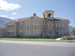
Payson is a city in Utah County, Utah, United States. It is part of the Provo–Orem Metropolitan Statistical Area. The population was 21,101 at the 2020 census.
Santaquin is a city in Utah and Juab counties in the U.S. state of Utah. It is part of the Provo–Orem metropolitan area. The population was 13,725 at the 2020 census.

Spanish Fork is a city in Utah County, Utah, United States. It is part of the Provo–Orem Metropolitan Statistical Area. The 2020 census reported a population of 42,602. Spanish Fork, Utah is the 20th largest city in Utah based on official 2017 estimates from the US Census Bureau.

The Wasatch Front is a metropolitan region in the north-central part of the U.S. state of Utah. It consists of a chain of mostly contiguous cities and towns stretched along the Wasatch Range from approximately Santaquin in the south to Logan in the north, and containing the cities of Salt Lake City, Provo, Orem, Bountiful, Layton, and Ogden.

Nebo School District is a public school district that serves the southern part of Utah County.

Mount Nebo is the southernmost and highest mountain in the Wasatch Range of Utah, in the United States, and the centerpiece of the Mount Nebo Wilderness, inside the Uinta National Forest. It is named after the biblical Mount Nebo, overlooking Israel from the east of the Jordan River, which is said to be the place of Moses' death.

Utah Valley is a valley in North Central Utah located in Utah County, and is considered part of the Wasatch Front. It contains the cities of Provo, Orem, and their suburbs, including Alpine, American Fork, Cedar Hills, Elk Ridge, Highland, Lehi, Lindon, Mapleton, Payson, Pleasant Grove, Salem, Santaquin, Saratoga Springs, Spanish Fork, Springville, Vineyard and Woodland Hills. It is known colloquially as "Happy Valley".
KTCE is a radio station broadcasting a Jazz format. Licensed to Payson, Utah, United States, it serves the Provo area. The station is currently owned by Moenkopi Communications, Inc. The station first became known as KTCE beginning in 1989. Although the station is lower power, it has often been heard as far north as Salt Lake City. Its studios are in Provo, and the transmitter site is on West Mountain west of Payson.

The Arizona National Scenic Trail is a National Scenic Trail from Mexico to Utah that traverses the whole north–south length of the U.S. state of Arizona. The trail begins at the Coronado National Memorial near the US–Mexico border and moves north through parts of the Huachuca, Santa Rita, and Rincon Mountains. The trail continues through the Santa Catalina north of Tucson and the Mazatzal Mountains before ascending the Mogollon Rim north of Payson, and eventually leading to the higher elevations of Northern Arizona and the San Francisco Peaks. The trail then continues across the Coconino Plateau and in and out of the Grand Canyon. The Arizona Trail terminates near the Arizona–Utah border in the Kaibab Plateau region. The 800-mile (1,300 km) long Arizona Trail was completed on December 16, 2011. The trail is designed as a primitive trail for hiking, equestrians, mountain biking, and even cross country skiing, showcasing the wide variety of mountain ranges and ecosystems of Arizona.
Mountain View Hospital can be one of the following:

Kanosh was a nineteenth-century leader of the Pahvant band of the Ute Indians of what is now central Utah having succeeded the more belligerent Chuick as principal chief. His band had "a major camp at Corn Creek." He is remembered for having been "friendly toward early Mormon Pioneer settlers."
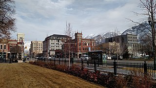
The Provo–Orem, UT Metropolitan Statistical Area, as defined by the United States Office of Management and Budget, is an area consisting of two counties in Utah, anchored by the cities of Provo and Orem. As of the 2020 census, the MSA had a population of 671,185.

West Mountain is a mountain in Utah, United States that is located 15.35 miles (25 km) southwest of the city of Provo, and 4.7 miles (8 km) west of the community of Benjamin. It is home to a radio station tower for KTCE, an FM station licensed to Payson and operating on 92.1 MHz. The mountain is also home to various FM radio translators and an observatory used by students from Brigham Young University (BYU). It can be accessed from a main road that starts near Benjamin. A small census designated place east of the mountain is known as West Mountain as well.

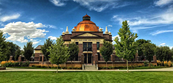
The Payson Utah Temple is a temple of the Church of Jesus Christ of Latter-day Saints in Payson, Utah. The temple is located on the southernmost edge of Utah's Wasatch Front, and is the 15th dedicated temple in the state.

State Route 115 (SR-115) is a state highway in the U.S. state of Utah, connecting Payson and Spanish Fork by way of Benjamin in southwestern Utah County. Running for 8.2 miles (13.20 km) as a two-lane highway, the road runs from SR-198 in Payson north to Benjamin, before heading west toward Spanish Fork and terminating at SR-156. The road was placed under state jurisdiction in the 1930s.

State route 147 (SR-147) is a state highway in the U.S. state of Utah. Spanning 18.175 miles (29.250 km), it connects West Mountain and Benjamin in western Utah Valley with Interstate 15 (I-15), Spanish Fork, and Mapleton on the east side of the valley.

Peteetneet Creek is a stream in Payson Canyon, south of Payson, Utah, United States.

