
Mount Baker, also known as Koma Kulshan or simply Kulshan, is a 10,781 ft (3,286 m) active glacier-covered andesitic stratovolcano in the Cascade Volcanic Arc and the North Cascades of Washington in the United States. Mount Baker has the second-most thermally active crater in the Cascade Range after Mount Saint Helens. About 30 miles (48 km) due east of the city of Bellingham, Whatcom County, Mount Baker is the youngest volcano in the Mount Baker volcanic field. While volcanism has persisted here for some 1.5 million years, the current volcanic cone is likely no more than 140,000 years old, and possibly no older than 80–90,000 years. Older volcanic edifices have mostly eroded away due to glaciation.

Friedrich Wolfgang Beckey, known as Fred Beckey, was an American rock climber, mountaineer and author, who made hundreds of first ascents, more than any other North American climber.

Mount Olympus, at 7,980 feet, is the tallest and most prominent mountain in the Olympic Mountains of western Washington state. Located on the Olympic Peninsula, it is also the central feature of Olympic National Park. Mount Olympus is the highest summit of the Olympic Mountains; however, peaks such as Mount Constance, on the eastern margin of the range, are better known, being visible from the Seattle metropolitan area.

Goat Rocks is an extinct stratovolcano in the Cascade Range, located between Mount Rainier and Mount Adams in southern Washington, in the United States. Part of the Cascade Volcanoes, it was formed by the subduction of the Juan de Fuca Plate under the western edge of the North American Plate. The volcano was active from 3.2 million years ago until eruptions ceased between 1 and 0.5 million years ago. Throughout its complex eruptive history, volcanism shifted from silicic explosive eruptions to voluminous, mafic activity.
Vesper Peak is a peak along the Mountain Loop Highway region of the North Cascades of Washington state. It is about 18 miles (29 km) south of Darrington and 21 miles (34 km) east of Granite Falls, in the Mount Baker-Snoqualmie National Forest. Its gentle south and east slopes contrast with a sheer north face which offers "excellent technical routes".

Mount Rainier, also known as Tahoma or Tacoma, is a large active stratovolcano in the Cascade Range of the Pacific Northwest, located 59 miles (95 km) south-southeast of Seattle, in Mount Rainier National Park. With a summit elevation of 14,411 ft (4,392 m), it is the highest mountain in the U.S. state of Washington, and of the Cascade Range, the most topographically prominent mountain in the contiguous United States, and the tallest in the Cascade Volcanic Arc.

Mount Triumph is a summit in the North Cascades range of Washington state. Located approximately 5.5 miles (8.9 km) west-northwest of the town of Newhalem, it was named by Lage Wernstedt, a surveyor with the U.S. Forest Service. A significant peak in North Cascades National Park, Mount Triumph is one of its "outstanding sights" and is well known among regional climbers for its lack of easy climbing routes to the summit. Despite its moderate elevation, its local relief is dramatic. With the terrain deeply dissected by the valleys of Bacon Creek on the west and Goodell Creek on the east, it rises 1 mile (1.6 km) in less than 2 miles (3.2 km) on the latter side.

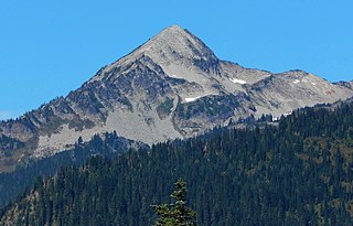
Mount Fernow is a tall peak in the North Cascades in the U.S. state of Washington and within the Glacier Peak Wilderness of the Wenatchee National Forest. At 9,249 feet (2,819 m) in elevation it is the eighth-highest peak in Washington and the state's third-highest non-volcanic peak. It is also the highest peak of the Entiat Mountains, a sub-range of the Cascades. Mount Fernow's prominence is 2,811 ft (857 m), making it the sixtieth-most-prominent peak in Washington. The closest peak to Fernow is Copper Peak, 0.88 mi (1.42 km) to the north, and the nearest higher peak is Bonanza Peak, 5.9 mi (9.5 km) to the north.

Buckner Mountain is a tall peak in the North Cascades of Washington state and in the Stephen Mather Wilderness of North Cascades National Park. At 9,114 feet (2,778 m) in elevation it is the highest in Skagit County and one of about ten of Washington's non-volcanic peaks above 9,000 feet high. It is ranked as the 14th highest peak in the state, and the third highest peak in North Cascades National Park.

Mount Redoubt is a mountain in the North Cascades range in Whatcom County, Washington state. The peak is located 3.0 miles (5 km) to the Canada–US border, 16.3 miles (26 km) east-northeast of Mount Shuksan. It is the 21st highest peak in the state, with a height of 8,956 feet (2,730 m) and a prominence of 1,649 feet (503 m). Redoubt is in the Skagit Range, a sub-range of the North Cascades, in the Custer-Chilliwack Group which includes Mount Spickard, Mount Redoubt, Mount Custer and Mox Peaks, among others. Redoubt, Bear, and Depot creeks drain off the mountain, which is composed of Skagit gneiss. Mount Redoubt is listed as one of the "Classic Eight Peaks" in the North Cascades.

Mount Spickard is a 8,980-foot (2,740 m) mountain peak in the North Cascades, a mountain range in the U.S. state of Washington. Located just 2 miles (3.2 km) south of the Canada–US border, it is part of the Chilliwack Group, a subrange of the Skagit Range which is part of the North Cascades. It is composed mainly of gneiss and is part of two major drainage basins: that of the Skagit River and Fraser River.

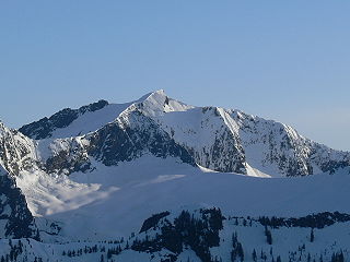
Sinister Peak is in Mount Baker-Snoqualmie and Wenatchee National Forests in the U.S. state of Washington. It is situated in Glacier Peak Wilderness and the North Cascades. Not quite 1 mi (1.6 km) east of Dome Peak, Sinister Peak is along a high ridge connecting the two peaks. The Chickamin Glacier is on the north slopes of Sinister Peak while the Garden Glacier is just southeast. Though some of the routes to the summit are technical, it can be reached by a moderate scramble.

Mount Formidable is a mountain in the North Cascades of Skagit County, in Washington state. Its first ascent was undertaken by members of the original Ptarmigan Traverse, and the peak is a popular climb for parties on the traverse. It was named by early mountaineer Herman Ulrichs in 1935 because of the rugged appearance of its north face. The peak is usually accessed from Cascade Pass via the Ptarmigan Traverse.

Ruth Mountain is a 7,115 ft (2,170 m) Skagit Range summit located two miles south of Hannegan Pass in the North Cascades of Washington state. The name honors Ruth Cleveland, daughter of President Grover Cleveland. This mountain's name was officially adopted in 1952 by the United States Board on Geographic Names. Ruth Mountain is situated on the shared border of North Cascades National Park and the Mount Baker Wilderness, which is part of the Mount Baker-Snoqualmie National Forest. The summit offers views of Mount Shuksan, East Nooksack Glacier, Seahpo Peak, Nooksack Tower, Icy Peak, Mount Sefrit, Mineral Mountain, and the Picket Range. The melting and receding Ruth Glacier on the north slope of Ruth creates the headwaters for the Chilliwack River. Precipitation runoff also finds its way into the Nooksack and Baker Rivers.

Cowlitz Chimneys are a group of four rhyolite towers located in Mount Rainier National Park in Pierce County of Washington state. As part of the Cascade Range, the Cowlitz Chimneys are situated southwest of Tamanos Mountain and east of Banshee Peak, all of which are visible from the Sunrise Historic District. The Sarvant Glacier is set on the north aspect of these remnants of a volcanic plug. Cowlitz is the name of several geographical features in Mount Rainier National Park, as well as the state of Washington. The name appeared as early as the Lewis and Clark journals of 1805 when it was written as "Cowliskee" and has the Chinook Jargon meaning of "capturing the medicine spirit".
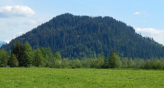
Pinnacle Peak, also known as Mount Peak, is a 1,801 ft forest-covered summit located in King County of Washington state. It is part of the Cascade Range and is set at the western edge of the range, immediately south of Enumclaw, Washington and 25 miles northwest of Mount Rainier. There is also another summit named Pinnacle Peak in the Tatoosh Range to the south of Mount Rainier.

Mount Meany is a prominent 6,695-foot (2,041-metre) mountain summit located deep within Olympic National Park in Jefferson County of Washington state. With a good eye and clear weather, the top of the mountain can be seen from the visitor center at Hurricane Ridge. Its nearest higher peak is Circe (6847 ft) on Mount Olympus, 4.07 mi (6.55 km) to the northwest. There are scrambling routes on the east side, via Noyes-Meany col, and via the ridge from Mount Queets. Due to heavy winter snowfalls, Mount Meany supports several small glaciers on its north and east slopes, despite its modest elevation. Precipitation runoff from the mountain drains into the headwaters of both the Elwha and Queets Rivers.
Pyramid Peak is a 6,937-foot (2,114-metre) mountain summit located in Mount Rainier National Park in Pierce County of Washington state. It is part of the Cascade Range and overlooks Indian Henry's Hunting Ground. It is situated at the base of the Success Cleaver, south of South Tahoma Glacier, and southwest of Pyramid Glacier. The summit provides views of Mount Rainier, Mount Adams, Mount St. Helens, and peaks of the Tatoosh Range. Precipitation runoff from Pyramid Peak drains into Pyramid Creek, Tahoma Creek, and Fishers Horn Pipe Creek, which are all tributaries of the Nisqually River.

Old Desolate is a 7,137 feet (2,175 m) multi-summit, ridge-like mountain located in Mount Rainier National Park, in Pierce County of Washington state. It is part of the Cascade Range, and lies 5 mi (8.0 km) due north of the summit of Mount Rainier. The Wonderland Trail provides an approach to this mountain, and the summit offers views of Sluiskin Mountain and Mount Rainier. Burroughs Mountain is its nearest higher neighbor, 2.37 mi (3.81 km) to the southeast. Precipitation runoff from Old Desolate drains east into the West Fork White River, or west into the Carbon River.
 Mt. Baker
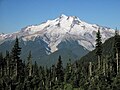 Glacier Peak
