
Stormwater, also spelled storm water, is water that originates from rain, including snow and ice melt. Stormwater can soak into the soil (infiltrate), be stored on the land surface in ponds and puddles, evaporate, or contribute to surface runoff. Most runoff is conveyed directly to nearby streams, rivers, or other water bodies without treatment.

A combined sewer is type of gravity sewer with a system of pipes, tunnels, pump stations etc. to transport sewage and urban runoff together to a sewage treatment plant or disposal site. This means that during rain events, the sewage gets diluted, resulting in higher flowrates at the treatment site. Uncontaminated stormwater simply dilutes sewage, but runoff may dissolve or suspend virtually anything it contacts on roofs, streets, and storage yards. As rainfall travels over roofs and the ground, it may pick up various contaminants including soil particles and other sediment, heavy metals, organic compounds, animal waste, and oil and grease. Combined sewers may also receive dry weather drainage from landscape irrigation, construction dewatering, and washing buildings and sidewalks.

First flush is the initial surface runoff of a rainstorm. During this phase, water pollution entering storm drains in areas with high proportions of impervious surfaces is typically more concentrated compared to the remainder of the storm. Consequently, these high concentrations of urban runoff result in high levels of pollutants discharged from storm sewers to surface waters.
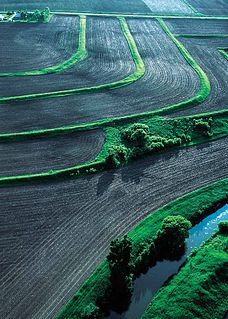
Erosion control is the practice of preventing or controlling wind or water erosion in agriculture, land development, coastal areas, river banks and construction. Effective erosion controls handle surface runoff and are important techniques in preventing water pollution, soil loss, wildlife habitat loss and human property loss.

Surface runoff is the flow of water occurring on the ground surface when excess rainwater, stormwater, meltwater, or other sources, can no longer sufficiently rapidly infiltrate in the soil. This can occur when the soil is saturated by water to its full capacity, and that the rain arrives more quickly than the soil can absorb it. Surface runoff often occurs because impervious areas do not allow water to soak into the ground. Furthermore, runoff can occur either through natural or man-made processes. Surface runoff is a major component of the water cycle. It is the primary agent of soil erosion by water. The land area producing runoff that drains to a common point is called a drainage basin.
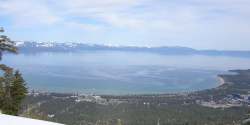
The DSSAM Model is a computer simulation developed for the Truckee River to analyze water quality impacts from land use and wastewater management decisions in the Truckee River Basin. This area includes the cities of Reno and Sparks, Nevada as well as the Lake Tahoe Basin. The model is historically and alternatively called the Earth Metrics Truckee River Model. Since original development in 1984-1986 under contract to the U.S. Environmental Protection Agency (EPA), the model has been refined and successive versions have been dubbed DSSAM II and DSSAM III. This hydrology transport model is based upon a pollutant loading metric called Total maximum daily load (TMDL). The success of this flagship model contributed to the Agency's broadened commitment to the use of the underlying TMDL protocol in its national policy for management of most river systems in the United States.

An hydrological transport model is a mathematical model used to simulate the flow of rivers, streams, groundwater movement or drainage front displacement, and calculate water quality parameters. These models generally came into use in the 1960s and 1970s when demand for numerical forecasting of water quality and drainage was driven by environmental legislation, and at a similar time widespread access to significant computer power became available. Much of the original model development took place in the United States and United Kingdom, but today these models are refined and used worldwide.

An infiltration basin, is a type of device that is used to manage stormwater runoff, prevent flooding and downstream erosion, and improve water quality in an adjacent river, stream, lake or bay. It is essentially a shallow artificial pond that is designed to infiltrate stormwater through permeable soils into the groundwater aquifer. Infiltration basins do not release water except by infiltration, evaporation or emergency overflow during flood conditions.
MIKE 11 is a computer program that simulates flow and water level, water quality and sediment transport in rivers, flood plains, irrigation canals, reservoirs and other inland water bodies. MIKE 11 is a 1-dimensional river model. It was developed by DHI.
MIKE FLOOD is a computer program that simulates inundation for rivers, flood plains and urban drainage systems. It dynamically couples 1D and 2D modeling techniques into one single tool. MIKE FLOOD is developed by DHI.
MIKE 21 is a computer program that simulates flows, waves, sediments and ecology in rivers, lakes, estuaries, bays, coastal areas and seas in two dimensions. It was developed by DHI.
MIKE 21C is a computer program that simulates the development in the river bed and channel plan form in two dimensions. MIKE 21C was developed by DHI. MIKE 21C uses curvilinear finite difference grids.
Urban runoff is surface runoff of rainwater, landscape irrigation, and car washing created by urbanization. Impervious surfaces are constructed during land development. During rain storms and other precipitation events, these surfaces, along with rooftops, carry polluted stormwater to storm drains, instead of allowing the water to percolate through soil. This causes lowering of the water table and flooding since the amount of water that remains on the surface is greater. Most municipal storm sewer systems discharge stormwater, untreated, to streams, rivers and bays. This excess water can also make its way into people's properties through basement backups and seepage through building wall and floors.

SHETRAN is a hydrological modelling system for water flow, solute and sediment transport in river catchments. SHETRAN is a physically based, distributed model (PBDM) that can simulate the entire land phase of the hydrologic cycle including surface water flow and groundwater flow. The plan area of the catchment in SHETRAN is usually in the range of one to a few thousand square kilometres and the horizontal depth of the subsurface is usually less than 100m.
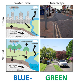
Water-sensitive urban design (WSUD) is a land planning and engineering design approach which integrates the urban water cycle, including stormwater, groundwater and wastewater management and water supply, into urban design to minimise environmental degradation and improve aesthetic and recreational appeal. WSUD is a term used in the Middle East and Australia and is similar to low-impact development (LID), a term used in the United States; and Sustainable Drainage System (SuDS), a term used in the United Kingdom.
A runoff footprint is the total surface runoff that a site produces over the course of a year. According to the United States Environmental Protection Agency (EPA) stormwater is "rainwater and melted snow that runs off streets, lawns, and other sites". Urbanized areas with high concentrations of impervious surfaces like buildings, roads, and driveways produce large volumes of runoff which can lead to flooding, sewer overflows, and poor water quality. Since soil in urban areas can be compacted and have a low infiltration rate, the surface runoff estimated in a runoff footprint is not just from impervious surfaces, but also pervious areas including yards. The total runoff is a measure of the site’s contribution to stormwater issues in an area, especially in urban areas with sewer overflows. Completing a runoff footprint for a site allows a property owner to understand what areas on his or her site are producing the most runoff and what scenarios of stormwater green solutions like rain barrels and rain gardens are most effective in mitigating this runoff and its costs to the community.

Microtox is an in vitro testing system which uses bioluminescent bacteria to detect toxic substances in different substrates such as water, air, soils and sediments. Allivibrio fischeri are non-pathogenic, marine, bacteria that luminesce as a natural part of their metabolism. When exposed to a toxic substance, the respiratory process of the bacteria is disrupted, reducing light output. Allivibrio fischeri have demonstrated high sensitivity across a wide variety of toxic substances. Response to toxicity is observed as a change in luminescence, which is a by-product of cellular respiration. This change can be used to calculate a percent inhibition of Allivibrio fischeri that directly correlates to toxicity.

OptiRTC is an American technology company that has developed a software as a service platform for civil infrastructure. The OptiRTC platform is a cloud-native platform that integrates sensors, forecasts, and environmental contexts to actively control stormwater infrastructure. The OptiRTC platform is built on Microsoft Azure and uses internet of things technology to predicatively manage distributed water systems.
DHI is an international water software development and engineering consultancy firm with headquarters in Denmark. The not-for-profit organisation addresses all challenges in water environments through consultancy services, MIKE Powered by DHI water modelling software, business applications, data portals and operational services. DHI has 30 offices throughout the world, with software development centres in Singapore and Denmark, and approximately 1050 employees.
HydroCAD is a computer-aided design (CAD) program used by civil engineers for modeling the hydrology and hydraulics (H&H) of stormwater runoff. Its use as a tool has grown in the U.S. as rules for managing stormwater have become more stringent. Specifically, the National Pollutant Discharge Elimination System (NPDES), last updated in December 2016, regulates point source pollution by municipal governments, industrial facilities and agricultural facilities. The NPDES was introduced in 1972 as part of the Clean Water Act, and is administered by the U.S. Environmental Protection Agency (EPA) in partnership with state environmental agencies.